![](/images/other/stat-length.png)
![Tocht Elektrische fiets Châtellerault - SityTrail - 001A Chatellerault to St Savin via La Puye - Photo](https://media.geolcdn.com/t/1900/400/ext.pjpeg?maxdim=2&url=https%3A%2F%2Fstatic1.geolcdn.com%2Fsiteimages%2Fupload%2Ffiles%2F1524743154velo.jpg)
SityTrail - 001A Chatellerault to St Savin via La Puye
Piper.Classique
Gebruiker
![Lengte](/images/other/stat-length.png)
Lengte
49 km
![Max. hoogte](https://static1.geolcdn.com/siteimages/upload/files/1508320355ic_sort_altitude_max_24dp.png)
Max. hoogte
142 m
![Positief hoogteverschil](https://static1.geolcdn.com/siteimages/upload/files/1508320355ic_sort_den_pos_24dp.png)
Positief hoogteverschil
509 m
![Km-Effort](/images/other/stat-length.png)
Km-Effort
56 km
![Min. hoogte](https://static1.geolcdn.com/siteimages/upload/files/1508320355ic_sort_altitude_min_24dp.png)
Min. hoogte
47 m
![Negatief hoogteverschil](https://static1.geolcdn.com/siteimages/upload/files/1508320355ic_sort_den_neg_24dp.png)
Negatief hoogteverschil
482 m
![Boucle](https://static1.geolcdn.com/siteimages/upload/files/16400158638029165_repeat_loop_refresh_sync_direction_icon.png)
Boucle
Neen
Datum van aanmaak :
2021-05-23 14:36:06.466
Laatste wijziging :
2021-07-14 13:14:54.65
![Elektrische fiets](https://static1.geolcdn.com/sitytour/trail-icons/205.png)
--
Moeilijkheid : Heel gemakkelijk
![Scan deze QR-code om de tocht te openen in de SityTrail-applicatie](https://capi.geolives.com/qq0zvz2zws4bq2lad0pu/sitytour/trails/2798356/qr.png?size=200)
Gratisgps-wandelapplicatie
Over ons
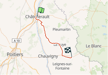
Tocht Elektrische fiets van 49 km beschikbaar op Nieuw-Aquitanië, Vienne, Châtellerault. Deze tocht wordt voorgesteld door Piper.Classique.
Beschrijving
The direct route missing out Angles sur l'Anglin but going through La Puye and Paizay. The preferred route. Untested but ought to work.
Plaatsbepaling
Land:
France
Regio :
Nieuw-Aquitanië
Departement/Provincie :
Vienne
Gemeente :
Châtellerault
Locatie:
Unknown
Vertrek:(Dec)
Vertrek:(UTM)
312636 ; 5187598 (31T) N.
Opmerkingen
Wandeltochten in de omgeving
![Stappen Stappen](https://static1.geolcdn.com/sitytour/trail-icons/101.png)
Châtellerault Manu Lyautey
Stappen
Gemakkelijk
Châtellerault,
Nieuw-Aquitanië,
Vienne,
France
![](/images/other/stat-length.png)
5,3 km | 5,7 km-effort
1h 17min
![](https://static1.geolcdn.com/siteimages/upload/files/16400158638029165_repeat_loop_refresh_sync_direction_icon.png)
Ja
![Tocht Stappen Châtellerault - 2024 06 01 Voie de Tours -Châtellerault -Dissay - Photo](https://media.geolcdn.com/t/375/260/c3eb91f7-df4b-4ecf-9ced-a7674ce4cea8.jpg&format=jpg&maxdim=2)
![Stappen Stappen](https://static1.geolcdn.com/sitytour/trail-icons/101.png)
2024 06 01 Voie de Tours -Châtellerault -Dissay
Stappen
Medium
Châtellerault,
Nieuw-Aquitanië,
Vienne,
France
![](/images/other/stat-length.png)
21 km | 24 km-effort
6h 1min
![](https://static1.geolcdn.com/siteimages/upload/files/16400158638029165_repeat_loop_refresh_sync_direction_icon.png)
Neen
![Stappen Stappen](https://static1.geolcdn.com/sitytour/trail-icons/101.png)
Antran la Girouette
Stappen
Medium
Antran,
Nieuw-Aquitanië,
Vienne,
France
![](/images/other/stat-length.png)
8,8 km | 9,6 km-effort
2h 11min
![](https://static1.geolcdn.com/siteimages/upload/files/16400158638029165_repeat_loop_refresh_sync_direction_icon.png)
Ja
![Tocht Stappen Châtellerault - Châtellerault vers ligne verte - Photo](https://media.geolcdn.com/t/375/260/ext.jpg?maxdim=2&url=https%3A%2F%2Fstatic1.geolcdn.com%2Fsiteimages%2Fupload%2Ffiles%2F1553511878bg_sport_marche.png)
![Stappen Stappen](https://static1.geolcdn.com/sitytour/trail-icons/101.png)
Châtellerault vers ligne verte
Stappen
Gemakkelijk
Châtellerault,
Nieuw-Aquitanië,
Vienne,
France
![](/images/other/stat-length.png)
4,8 km | 5,2 km-effort
1h 11min
![](https://static1.geolcdn.com/siteimages/upload/files/16400158638029165_repeat_loop_refresh_sync_direction_icon.png)
Ja
![Tocht Stappen Cenon-sur-Vienne - Cenon-sur-Vienne les Varennes 5,7 - Photo](https://media.geolcdn.com/t/375/260/ext.jpg?maxdim=2&url=https%3A%2F%2Fstatic1.geolcdn.com%2Fsiteimages%2Fupload%2Ffiles%2F1553511878bg_sport_marche.png)
![Stappen Stappen](https://static1.geolcdn.com/sitytour/trail-icons/101.png)
Cenon-sur-Vienne les Varennes 5,7
Stappen
Medium
Cenon-sur-Vienne,
Nieuw-Aquitanië,
Vienne,
France
![](/images/other/stat-length.png)
5,7 km | 6,3 km-effort
1h 25min
![](https://static1.geolcdn.com/siteimages/upload/files/16400158638029165_repeat_loop_refresh_sync_direction_icon.png)
Ja
![Tocht Stappen Cenon-sur-Vienne - Cenon-sur-Vienne les Varennes - Photo](https://media.geolcdn.com/t/375/260/ext.jpg?maxdim=2&url=https%3A%2F%2Fstatic1.geolcdn.com%2Fsiteimages%2Fupload%2Ffiles%2F1553511878bg_sport_marche.png)
![Stappen Stappen](https://static1.geolcdn.com/sitytour/trail-icons/101.png)
Cenon-sur-Vienne les Varennes
Stappen
Gemakkelijk
Cenon-sur-Vienne,
Nieuw-Aquitanië,
Vienne,
France
![](/images/other/stat-length.png)
4,8 km | 5,1 km-effort
1h 10min
![](https://static1.geolcdn.com/siteimages/upload/files/16400158638029165_repeat_loop_refresh_sync_direction_icon.png)
Ja
![Tocht Stappen Châtellerault - Châtellerault Manu Lyautey - Photo](https://media.geolcdn.com/t/375/260/ext.jpg?maxdim=2&url=https%3A%2F%2Fstatic1.geolcdn.com%2Fsiteimages%2Fupload%2Ffiles%2F1553511878bg_sport_marche.png)
![Stappen Stappen](https://static1.geolcdn.com/sitytour/trail-icons/101.png)
Châtellerault Manu Lyautey
Stappen
Gemakkelijk
Châtellerault,
Nieuw-Aquitanië,
Vienne,
France
![](/images/other/stat-length.png)
5,4 km | 5,9 km-effort
1h 20min
![](https://static1.geolcdn.com/siteimages/upload/files/16400158638029165_repeat_loop_refresh_sync_direction_icon.png)
Ja
![Tocht Stappen Châtellerault - Châtellerault vers ligne verte - Photo](https://media.geolcdn.com/t/375/260/ext.jpg?maxdim=2&url=https%3A%2F%2Fstatic1.geolcdn.com%2Fsiteimages%2Fupload%2Ffiles%2F1553511878bg_sport_marche.png)
![Stappen Stappen](https://static1.geolcdn.com/sitytour/trail-icons/101.png)
Châtellerault vers ligne verte
Stappen
Gemakkelijk
Châtellerault,
Nieuw-Aquitanië,
Vienne,
France
![](/images/other/stat-length.png)
4,9 km | 5,3 km-effort
1h 11min
![](https://static1.geolcdn.com/siteimages/upload/files/16400158638029165_repeat_loop_refresh_sync_direction_icon.png)
Ja
![Tocht Stappen Châtellerault - Châtellerault bords de Vienne - Photo](https://media.geolcdn.com/t/375/260/ext.jpg?maxdim=2&url=https%3A%2F%2Fstatic1.geolcdn.com%2Fsiteimages%2Fupload%2Ffiles%2F1553511878bg_sport_marche.png)
![Stappen Stappen](https://static1.geolcdn.com/sitytour/trail-icons/101.png)
Châtellerault bords de Vienne
Stappen
Medium
Châtellerault,
Nieuw-Aquitanië,
Vienne,
France
![](/images/other/stat-length.png)
8,5 km | 9,2 km-effort
2h 2min
![](https://static1.geolcdn.com/siteimages/upload/files/16400158638029165_repeat_loop_refresh_sync_direction_icon.png)
Ja