![](/images/other/stat-length.png)
20210423 - HUWAO - Solwaster 7.5 Km
pierreh01
Gebruiker GUIDE
![Lengte](/images/other/stat-length.png)
Lengte
7,8 km
![Max. hoogte](https://static1.geolcdn.com/siteimages/upload/files/1508320355ic_sort_altitude_max_24dp.png)
Max. hoogte
599 m
![Positief hoogteverschil](https://static1.geolcdn.com/siteimages/upload/files/1508320355ic_sort_den_pos_24dp.png)
Positief hoogteverschil
131 m
![Km-Effort](/images/other/stat-length.png)
Km-Effort
9,5 km
![Min. hoogte](https://static1.geolcdn.com/siteimages/upload/files/1508320355ic_sort_altitude_min_24dp.png)
Min. hoogte
478 m
![Negatief hoogteverschil](https://static1.geolcdn.com/siteimages/upload/files/1508320355ic_sort_den_neg_24dp.png)
Negatief hoogteverschil
130 m
![Boucle](https://static1.geolcdn.com/siteimages/upload/files/16400158638029165_repeat_loop_refresh_sync_direction_icon.png)
Boucle
Ja
Datum van aanmaak :
2021-05-23 11:56:48.0
Laatste wijziging :
2021-05-23 16:08:47.865
![Stappen](https://static1.geolcdn.com/sitytour/trail-icons/101.png)
2h20
Moeilijkheid : Gemakkelijk
![Scan deze QR-code om de tocht te openen in de SityTrail-applicatie](https://capi.geolives.com/qq0zvz2zws4bq2lad0pu/sitytour/trails/2798292/qr.png?size=200)
Gratisgps-wandelapplicatie
Over ons
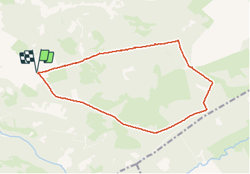
Tocht Stappen van 7,8 km beschikbaar op Wallonië, Luik, Jalhay. Deze tocht wordt voorgesteld door pierreh01.
Beschrijving
Balade HUWAO de ce dimanche 23 mai 2021 dans les bois de Solwaster, sous une météo assez clémente, sans difficulté.
Promenade balisée du Syndicat d'Initiative de Jalhay (Balade familiale Fagne Marron - Solwaster) - Losange horizontal rouge.
Plaatsbepaling
Land:
Belgium
Regio :
Wallonië
Departement/Provincie :
Luik
Gemeente :
Jalhay
Locatie:
Unknown
Vertrek:(Dec)
Vertrek:(UTM)
711330 ; 5599666 (31U) N.
Opmerkingen
Wandeltochten in de omgeving
![Tocht Stappen Malmedy - RB-Lg-31_Malmedy - Photo](https://media.geolcdn.com/t/375/260/ext.jpg?maxdim=2&url=https%3A%2F%2Fservices.sitytrail.com%2FGeolivesWS%2FDownloadMedia.ashx%3FTrailID%3D402114%26Media%3D216d2e53-3b66-4632-8b4d-0cea30889665.jpg)
![Stappen Stappen](https://static1.geolcdn.com/sitytour/trail-icons/101.png)
![Tocht Stappen Jalhay - RB-LG-06 Raccourci 2 - Photo](https://media.geolcdn.com/t/375/260/ext.jpg?maxdim=2&url=https%3A%2F%2Fservices.sitytrail.com%2FGeolivesWS%2FDownloadMedia.ashx%3FTrailID%3D209412%26Media%3Dcbaa668b-becb-4b36-acb0-64f56a1c97b3.jpg)
![Stappen Stappen](https://static1.geolcdn.com/sitytour/trail-icons/101.png)
RB-LG-06 Raccourci 2
Stappen
Moeilijk
(6)
Jalhay,
Wallonië,
Luik,
Belgium
![](/images/other/stat-length.png)
10,1 km | 13,3 km-effort
3h 1min
![](https://static1.geolcdn.com/siteimages/upload/files/16400158638029165_repeat_loop_refresh_sync_direction_icon.png)
Ja
![Tocht Stappen Jalhay - RB-LG-06 - Au pied du plateau des Hautes Fagnes La balade des ruisseaux - Photo](https://media.geolcdn.com/t/375/260/ext.jpg?maxdim=2&url=https%3A%2F%2Fservices.sitytrail.com%2FGeolivesWS%2FDownloadMedia.ashx%3FTrailID%3D179564%26Media%3Dcbaa668b-becb-4b36-acb0-64f56a1c97b3.jpg)
![Stappen Stappen](https://static1.geolcdn.com/sitytour/trail-icons/101.png)
RB-LG-06 - Au pied du plateau des Hautes Fagnes La balade des ruisseaux
Stappen
Zeer moeilijk
(7)
Jalhay,
Wallonië,
Luik,
Belgium
![](/images/other/stat-length.png)
26 km | 35 km-effort
8h 0min
![](https://static1.geolcdn.com/siteimages/upload/files/16400158638029165_repeat_loop_refresh_sync_direction_icon.png)
Ja
![Tocht Stappen Jalhay - Solwaster. Natura 2000, des sites qui valent le détour. Lg8 - Photo](https://media.geolcdn.com/t/375/260/ext.jpg?maxdim=2&url=https%3A%2F%2Fservices.sitytrail.com%2FGeolivesWS%2FDownloadMedia.ashx%3FTrailID%3D185776%26Media%3D07ec0791-d24b-4377-8f42-10c75b77cede.jpg)
![Stappen Stappen](https://static1.geolcdn.com/sitytour/trail-icons/101.png)
Solwaster. Natura 2000, des sites qui valent le détour. Lg8
Stappen
Moeilijk
(9)
Jalhay,
Wallonië,
Luik,
Belgium
![](/images/other/stat-length.png)
6,8 km | 9,1 km-effort
1h 58min
![](https://static1.geolcdn.com/siteimages/upload/files/16400158638029165_repeat_loop_refresh_sync_direction_icon.png)
Ja
![Tocht Stappen Jalhay - Pont de Belleheid à Spa par le GRP 573 - Photo](https://media.geolcdn.com/t/375/260/0d2f83e8-ec88-4180-940e-6c42b7bb9bcf.jpg&format=jpg&maxdim=2)
![Stappen Stappen](https://static1.geolcdn.com/sitytour/trail-icons/101.png)
Pont de Belleheid à Spa par le GRP 573
Stappen
Medium
(1)
Jalhay,
Wallonië,
Luik,
Belgium
![](/images/other/stat-length.png)
14 km | 17,8 km-effort
4h 2min
![](https://static1.geolcdn.com/siteimages/upload/files/16400158638029165_repeat_loop_refresh_sync_direction_icon.png)
Neen
![Stappen Stappen](https://static1.geolcdn.com/sitytour/trail-icons/101.png)
20211213 - Hockay 5.4 Km
Stappen
Medium
(3)
Stavelot,
Wallonië,
Luik,
Belgium
![](/images/other/stat-length.png)
5,1 km | 6,6 km-effort
1h 34min
![](https://static1.geolcdn.com/siteimages/upload/files/16400158638029165_repeat_loop_refresh_sync_direction_icon.png)
Ja
![Tocht Stappen Jalhay - 2021-11-16_21h12m11_Cirkwi-Solwaster_Sawe_-_balade_56_B (1) - Photo](https://media.geolcdn.com/t/375/260/081cadfc-4766-4923-92bf-f568c48bec7d.jpg&format=jpg&maxdim=2)
![Stappen Stappen](https://static1.geolcdn.com/sitytour/trail-icons/101.png)
2021-11-16_21h12m11_Cirkwi-Solwaster_Sawe_-_balade_56_B (1)
Stappen
Medium
(3)
Jalhay,
Wallonië,
Luik,
Belgium
![](/images/other/stat-length.png)
8,5 km | 11,4 km-effort
2h 36min
![](https://static1.geolcdn.com/siteimages/upload/files/16400158638029165_repeat_loop_refresh_sync_direction_icon.png)
Ja
![Tocht Lopen Jalhay - Jalhay-Trail-26km - Photo](https://media.geolcdn.com/t/375/260/cfb58ec0-2055-46b2-8eac-aa502bd39e7d.jpg&format=jpg&maxdim=2)
![Lopen Lopen](https://static1.geolcdn.com/sitytour/trail-icons/103.png)
Jalhay-Trail-26km
Lopen
Moeilijk
(9)
Jalhay,
Wallonië,
Luik,
Belgium
![](/images/other/stat-length.png)
26 km | 34 km-effort
3h 0min
![](https://static1.geolcdn.com/siteimages/upload/files/16400158638029165_repeat_loop_refresh_sync_direction_icon.png)
Ja
![Tocht Stappen Stavelot - Hockai ❄️☃️ - Photo](https://media.geolcdn.com/t/375/260/a5e9d4f4-0133-456e-a4c0-187a5c868dc0.jpg&format=jpg&maxdim=2)
![Stappen Stappen](https://static1.geolcdn.com/sitytour/trail-icons/101.png)