![](/images/other/stat-length.png)
![Tocht Stappen Valliguières - Valliguieres - comble de Vayer - Photo](https://media.geolcdn.com/t/1900/400/66af09b0-a1a9-42fc-b677-899b9c73ea8e.jpg&format=pjpeg&maxdim=2)
Valliguieres - comble de Vayer
Manoune
Gebruiker
![Lengte](/images/other/stat-length.png)
![Max. hoogte](https://static1.geolcdn.com/siteimages/upload/files/1508320355ic_sort_altitude_max_24dp.png)
![Positief hoogteverschil](https://static1.geolcdn.com/siteimages/upload/files/1508320355ic_sort_den_pos_24dp.png)
![Km-Effort](/images/other/stat-length.png)
![Min. hoogte](https://static1.geolcdn.com/siteimages/upload/files/1508320355ic_sort_altitude_min_24dp.png)
![Negatief hoogteverschil](https://static1.geolcdn.com/siteimages/upload/files/1508320355ic_sort_den_neg_24dp.png)
![Boucle](https://static1.geolcdn.com/siteimages/upload/files/16400158638029165_repeat_loop_refresh_sync_direction_icon.png)
![Stappen](https://static1.geolcdn.com/sitytour/trail-icons/101.png)
4h44
Moeilijkheid : Medium
![Scan deze QR-code om de tocht te openen in de SityTrail-applicatie](https://capi.geolives.com/qq0zvz2zws4bq2lad0pu/sitytour/trails/2798157/qr.png?size=200)
Gratisgps-wandelapplicatie
Over ons
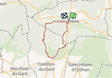
Tocht Stappen van 12,7 km beschikbaar op Occitanië, Gard, Valliguières. Deze tocht wordt voorgesteld door Manoune.
Beschrijving
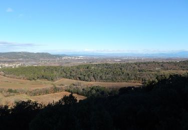
Départ , parking des randonneurs à l'entrée du Hameau, visite du village, cimetière, les Combettes, les Rozières, Grotte le Méjan (attention montée assez raide et surtout à cas de temps humide risque de glissade), Vue sur Castillon du Gard, vue St Hilaire d'Ozillan, L'Homme Mort, Antennes, parking.
Bonne randonnée.
Plaatsbepaling
Opmerkingen
Wandeltochten in de omgeving
![Tocht Stappen Pouzilhac - Le sentier botanique - Pouzilhac - Photo](https://media.geolcdn.com/t/375/260/ext.jpg?maxdim=2&url=https%3A%2F%2Fservices.sitytrail.com%2FGeolivesWS%2FDownloadMedia.ashx%3FTrailID%3D317463%26Media%3D16695_6.jpg)
![Stappen Stappen](https://static1.geolcdn.com/sitytour/trail-icons/101.png)
Stappen
![](/images/other/stat-length.png)
![](https://static1.geolcdn.com/siteimages/upload/files/16400158638029165_repeat_loop_refresh_sync_direction_icon.png)
![Tocht Stappen Valliguières - Valliguières - St Pierre - Solidarité - Photo](https://media.geolcdn.com/t/375/260/34c7644f-964a-475b-8438-72b62b10d114.jpg&format=jpg&maxdim=2)
![Stappen Stappen](https://static1.geolcdn.com/sitytour/trail-icons/101.png)
Stappen
![](/images/other/stat-length.png)
![](https://static1.geolcdn.com/siteimages/upload/files/16400158638029165_repeat_loop_refresh_sync_direction_icon.png)
![Tocht Stappen Valliguières - Valliguières - Etang - St Pierre - Photo](https://media.geolcdn.com/t/375/260/34c7644f-964a-475b-8438-72b62b10d114.jpg&format=jpg&maxdim=2)
![Stappen Stappen](https://static1.geolcdn.com/sitytour/trail-icons/101.png)
Stappen
![](/images/other/stat-length.png)
![](https://static1.geolcdn.com/siteimages/upload/files/16400158638029165_repeat_loop_refresh_sync_direction_icon.png)
![Tocht Stappen Vers-Pont-du-Gard - Vers-pont-du-gard panorama-dfci - Photo](https://media.geolcdn.com/t/375/260/364a41da-e920-4623-9a68-e6731453cac6.jpg&format=jpg&maxdim=2)
![Stappen Stappen](https://static1.geolcdn.com/sitytour/trail-icons/101.png)
Stappen
![](/images/other/stat-length.png)
![](https://static1.geolcdn.com/siteimages/upload/files/16400158638029165_repeat_loop_refresh_sync_direction_icon.png)
![Tocht Stappen Saint-Hilaire-d'Ozilhan - SAINT-HILAIRE-D OZILHAN - FORET DE VALLONGUE - 11.7Km - 03h20 - Dénivelé 250 m - Photo](https://media.geolcdn.com/t/375/260/ext.jpg?maxdim=2&url=https%3A%2F%2Fstatic1.geolcdn.com%2Fsiteimages%2Fupload%2Ffiles%2F1553511878bg_sport_marche.png)
![Stappen Stappen](https://static1.geolcdn.com/sitytour/trail-icons/101.png)
Stappen
![](/images/other/stat-length.png)
![](https://static1.geolcdn.com/siteimages/upload/files/16400158638029165_repeat_loop_refresh_sync_direction_icon.png)
![Tocht Stappen Vers-Pont-du-Gard - Vers-Pont-du-Guard - Photo](https://media.geolcdn.com/t/375/260/ext.jpg?maxdim=2&url=https%3A%2F%2Fstatic1.geolcdn.com%2Fsiteimages%2Fupload%2Ffiles%2F1553511878bg_sport_marche.png)
![Stappen Stappen](https://static1.geolcdn.com/sitytour/trail-icons/101.png)
Stappen
![](/images/other/stat-length.png)
![](https://static1.geolcdn.com/siteimages/upload/files/16400158638029165_repeat_loop_refresh_sync_direction_icon.png)
![Tocht Stappen Vers-Pont-du-Gard - le-pont-du-gard-10km+175m.2024 - Photo](https://media.geolcdn.com/t/375/260/9ff5d1f9-99ef-47d9-8816-121bdee7a541.jpg&format=jpg&maxdim=2)
![Stappen Stappen](https://static1.geolcdn.com/sitytour/trail-icons/101.png)
Stappen
![](/images/other/stat-length.png)
![](https://static1.geolcdn.com/siteimages/upload/files/16400158638029165_repeat_loop_refresh_sync_direction_icon.png)
![Tocht Stappen Vers-Pont-du-Gard - Vers-Carrieres_20210310_1442 - Photo](https://media.geolcdn.com/t/375/260/d24a7fb9-e480-4158-972f-ef80b017a25f.jpg&format=jpg&maxdim=2)
![Stappen Stappen](https://static1.geolcdn.com/sitytour/trail-icons/101.png)
Stappen
![](/images/other/stat-length.png)
![](https://static1.geolcdn.com/siteimages/upload/files/16400158638029165_repeat_loop_refresh_sync_direction_icon.png)
![Tocht Stappen Saint-Hilaire-d'Ozilhan - St Hilaire d](https://media.geolcdn.com/t/375/260/8bc2d294-686a-4641-919c-52697b9ba260.jpg&format=jpg&maxdim=2)
![Stappen Stappen](https://static1.geolcdn.com/sitytour/trail-icons/101.png)
Stappen
![](/images/other/stat-length.png)
![](https://static1.geolcdn.com/siteimages/upload/files/16400158638029165_repeat_loop_refresh_sync_direction_icon.png)