Tocht Mountainbike De Wolden - Drenthe - Veldtoertocht de Wijk 2002 - Photo

Drenthe - Veldtoertocht de Wijk 2002

 gpstracks
gpstracks

Gebruiker

© OpenStreetMap contributors
Lengte
Lengte
25 km
Max. hoogte
Max. hoogte
16 m
Positief hoogteverschil
150 m
Km-Effort
Km-Effort  
27 km
Min. hoogte
Min. hoogte
-1 m
Negatief hoogteverschil
152 m
Boucle
Boucle
Ja
Datum van aanmaak :
2014-12-10 00:00:00.0
Laatste wijziging :
2014-12-10 00:00:00.0

(0 Bericht)

Mountainbike
Mountainbike
--
Moeilijkheid : Onbekend

Scan deze QR-code om de tocht te openen in de SityTrail-applicatie

Gratisgps-wandelapplicatie

Logo SityTrail SityTrail

IGN / Geografische instituten

SityTrail uit de App Store downloaden SityTrail uit Google Play downloaden

Logo SityTrail SityTrail World

De wereld gaat voor u open

SityTrail uit de App Store downloaden SityTrail uit Google Play downloaden SityTrail op Huawei AppGallery downloaden

Over ons

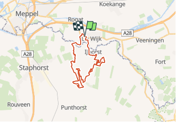
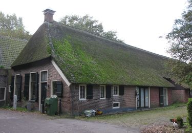
Tocht Mountainbike van 25 km beschikbaar op Drenthe, Onbekend, De Wolden. Deze tocht wordt voorgesteld door gpstracks.

Beschrijving

More information on GPStracks.nl : http://www.gpstracks.nl

Hoogteprofiel

POI's

POI De Wolden - START - Photo
gpstracks
DE WOLDEN 

Plaatsbepaling

Land:
Netherlands
Regio :
Drenthe
Departement/Provincie :
Onbekend
Gemeente :
De Wolden
Locatie:
Unknown
Vertrek:(Dec)
Vertrek:(UTM)
316077 ; 5839413 (32U) N.

Wandeltochten in de omgeving

Tocht Te voet Staphorst - Kuierpad IJhorst bruin - Photo
Te voet
GUIDE+

Te voet

Gemakkelijk
Staphorst, Overijssel, Onbekend, Netherlands
5,5 km | 6 km-effort
1h 22min
Ja
Tocht Te voet Staphorst - WNW Vechtdal -Staphorst - oranje route - Photo
Te voet
GUIDE+

Te voet

Gemakkelijk
Staphorst, Overijssel, Onbekend, Netherlands
3,4 km | 3,5 km-effort
47min
Ja
Tocht Te voet Staphorst - WNW Vechtdal - Staphorst - rode route - Photo
Te voet
GUIDE+

Te voet

Gemakkelijk
Staphorst, Overijssel, Onbekend, Netherlands
10,3 km | 10,6 km-effort
2h 24min
Ja
Tocht Te voet Staphorst - WNW Vechtdal -Staphorst - groene route - Photo
Te voet
GUIDE+

Te voet

Gemakkelijk
Staphorst, Overijssel, Onbekend, Netherlands
14,7 km | 15,3 km-effort
3h 28min
Ja
Tocht Te voet Staphorst - WNW Vechtdal -Staphorst - gele route - Photo
Te voet
GUIDE+

Te voet

Gemakkelijk
Staphorst, Overijssel, Onbekend, Netherlands
8,5 km | 9 km-effort
2h 2min
Ja
Tocht Te voet Staphorst - WNW Vechtdal -Reeststouwe - paarse route - Photo
Te voet
GUIDE+

Te voet

Gemakkelijk
Staphorst, Overijssel, Onbekend, Netherlands
6,6 km | 6,8 km-effort
1h 32min
Ja
Tocht Te voet Staphorst - WNW Vechtdal -Reeststouwe - oranje route - Photo
Te voet
GUIDE+

Te voet

Medium
Staphorst, Overijssel, Onbekend, Netherlands
22 km | 23 km-effort
5h 11min
Ja
Tocht Te voet Staphorst - WNW Vechtdal - Zwarte Venen - paarse route - Photo
Te voet
GUIDE+

Te voet

Gemakkelijk
Staphorst, Overijssel, Onbekend, Netherlands
3,6 km | 3,7 km-effort
50min
Neen
Tocht Motor Meppel - a-drenthe-rondje-westerveld - Photo
Motor
gpstracks

Motor

Heel gemakkelijk
Meppel, Drenthe, Onbekend, Netherlands
83 km | 88 km-effort
Onbekend
Neen


Sluiten
Mijn abonnementen