![](/images/other/stat-length.png)
![Tocht Stappen Vernègues - Vernègues 21 Mai 2021 - Photo](https://media.geolcdn.com/t/1900/400/95feefb2-9796-40ec-9b8c-a9cdb29699ed.jpg&format=pjpeg&maxdim=2)
Vernègues 21 Mai 2021
ALAPETITE
Gebruiker
![Lengte](/images/other/stat-length.png)
Lengte
10,8 km
![Max. hoogte](https://static1.geolcdn.com/siteimages/upload/files/1508320355ic_sort_altitude_max_24dp.png)
Max. hoogte
385 m
![Positief hoogteverschil](https://static1.geolcdn.com/siteimages/upload/files/1508320355ic_sort_den_pos_24dp.png)
Positief hoogteverschil
256 m
![Km-Effort](/images/other/stat-length.png)
Km-Effort
14,2 km
![Min. hoogte](https://static1.geolcdn.com/siteimages/upload/files/1508320355ic_sort_altitude_min_24dp.png)
Min. hoogte
187 m
![Negatief hoogteverschil](https://static1.geolcdn.com/siteimages/upload/files/1508320355ic_sort_den_neg_24dp.png)
Negatief hoogteverschil
258 m
![Boucle](https://static1.geolcdn.com/siteimages/upload/files/16400158638029165_repeat_loop_refresh_sync_direction_icon.png)
Boucle
Ja
Datum van aanmaak :
2021-05-21 11:13:02.319
Laatste wijziging :
2021-05-21 14:20:35.411
![Stappen](https://static1.geolcdn.com/sitytour/trail-icons/101.png)
2h18
Moeilijkheid : Heel gemakkelijk
![Scan deze QR-code om de tocht te openen in de SityTrail-applicatie](https://capi.geolives.com/qq0zvz2zws4bq2lad0pu/sitytour/trails/2795254/qr.png?size=200)
Gratisgps-wandelapplicatie
Over ons
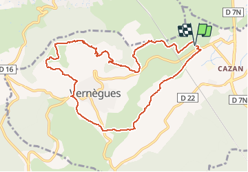
Tocht Stappen van 10,8 km beschikbaar op Provence-Alpes-Côte d'Azur, Bouches-du-Rhône, Vernègues. Deze tocht wordt voorgesteld door ALAPETITE.
Beschrijving
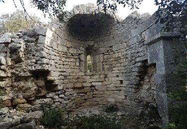
Saint Symphorien, borne milliaire, borie municipale, bassin renversé, point de vue sur le Nord, table orientation, constance, chemin Saint Anne, descente vers Pavillon Victoire, chemin de Vinsargues, Saint Symphorien.
Plaatsbepaling
Land:
France
Regio :
Provence-Alpes-Côte d'Azur
Departement/Provincie :
Bouches-du-Rhône
Gemeente :
Vernègues
Locatie:
Unknown
Vertrek:(Dec)
Vertrek:(UTM)
677072 ; 4840288 (31T) N.
Opmerkingen
Wandeltochten in de omgeving
![Stappen Stappen](https://static1.geolcdn.com/sitytour/trail-icons/101.png)
PF-Alleins - Chapelle Saint-Jean - Rousset - Tour Vieille - Vallon de Valcros...
Stappen
Gemakkelijk
(1)
Alleins,
Provence-Alpes-Côte d'Azur,
Bouches-du-Rhône,
France
![](/images/other/stat-length.png)
7,1 km | 9 km-effort
2h 30min
![](https://static1.geolcdn.com/siteimages/upload/files/16400158638029165_repeat_loop_refresh_sync_direction_icon.png)
Ja
![Tocht Stappen Charleval - PF-Charleval - Les Costes - Bois des Taillades - Cuou de Peyrou - Photo](https://media.geolcdn.com/t/375/260/67a220c4-295b-4d31-b693-d6441f3ed082.jpg&format=jpg&maxdim=2)
![Stappen Stappen](https://static1.geolcdn.com/sitytour/trail-icons/101.png)
PF-Charleval - Les Costes - Bois des Taillades - Cuou de Peyrou
Stappen
Gemakkelijk
(1)
Charleval,
Provence-Alpes-Côte d'Azur,
Bouches-du-Rhône,
France
![](/images/other/stat-length.png)
5,2 km | 7,2 km-effort
2h 27min
![](https://static1.geolcdn.com/siteimages/upload/files/16400158638029165_repeat_loop_refresh_sync_direction_icon.png)
Ja
![Tocht Stappen Vernègues - Château bas-Vernègues-chapelle - Photo](https://media.geolcdn.com/t/375/260/9b82dc84-47a8-451b-adac-f7c55291d235.jpg&format=jpg&maxdim=2)
![Stappen Stappen](https://static1.geolcdn.com/sitytour/trail-icons/101.png)
Château bas-Vernègues-chapelle
Stappen
Gemakkelijk
(3)
Vernègues,
Provence-Alpes-Côte d'Azur,
Bouches-du-Rhône,
France
![](/images/other/stat-length.png)
9,8 km | 12 km-effort
2h 42min
![](https://static1.geolcdn.com/siteimages/upload/files/16400158638029165_repeat_loop_refresh_sync_direction_icon.png)
Ja
![Tocht Stappen Alleins - Vernegues, St Jean, Rousset, St Georges, Tour Vieille. - Photo](https://media.geolcdn.com/t/375/260/ext.jpg?maxdim=2&url=https%3A%2F%2Fservices.sitytrail.com%2FGeolivesWS%2FDownloadMedia.ashx%3FTrailID%3D696925%26Media%3Dfix__20170212100152.jpg)
![Stappen Stappen](https://static1.geolcdn.com/sitytour/trail-icons/101.png)
Vernegues, St Jean, Rousset, St Georges, Tour Vieille.
Stappen
Heel gemakkelijk
(1)
Alleins,
Provence-Alpes-Côte d'Azur,
Bouches-du-Rhône,
France
![](/images/other/stat-length.png)
8,1 km | 10,4 km-effort
2h 6min
![](https://static1.geolcdn.com/siteimages/upload/files/16400158638029165_repeat_loop_refresh_sync_direction_icon.png)
Ja
![Tocht Andere activiteiten Aurons - cabanon douceur - Photo](https://media.geolcdn.com/t/375/260/ext.jpg?maxdim=2&url=https%3A%2F%2Fservices.sitytrail.com%2FGeolivesWS%2FDownloadMedia.ashx%3FTrailID%3D568585%26Media%3Dfix__20160512110504.jpg)
![Andere activiteiten Andere activiteiten](https://static1.geolcdn.com/sitytour/trail-icons/900.png)
cabanon douceur
Andere activiteiten
Heel gemakkelijk
(2)
Aurons,
Provence-Alpes-Côte d'Azur,
Bouches-du-Rhône,
France
![](/images/other/stat-length.png)
6,6 km | 8,2 km-effort
3h 4min
![](https://static1.geolcdn.com/siteimages/upload/files/16400158638029165_repeat_loop_refresh_sync_direction_icon.png)
Ja
![Tocht Stappen Vernègues - PF-Vernègues - Château Bas-Badasset-Vernègues - Photo](https://media.geolcdn.com/t/375/260/ext.jpg?maxdim=2&url=https%3A%2F%2Fservices.sitytrail.com%2FGeolivesWS%2FDownloadMedia.ashx%3FTrailID%3D524378%26Media%3D20160211154541.jpg)
![Stappen Stappen](https://static1.geolcdn.com/sitytour/trail-icons/101.png)
PF-Vernègues - Château Bas-Badasset-Vernègues
Stappen
Gemakkelijk
(1)
Vernègues,
Provence-Alpes-Côte d'Azur,
Bouches-du-Rhône,
France
![](/images/other/stat-length.png)
7,8 km | 9,7 km-effort
2h 8min
![](https://static1.geolcdn.com/siteimages/upload/files/16400158638029165_repeat_loop_refresh_sync_direction_icon.png)
Ja
![Tocht Mountainbike Aurons - Les Deux Bosquets - Photo](https://media.geolcdn.com/t/375/260/ext.jpg?maxdim=2&url=https%3A%2F%2Fservices.sitytrail.com%2FGeolivesWS%2FDownloadMedia.ashx%3FTrailID%3D108560%26Media%3D1468_2.jpg)
![Mountainbike Mountainbike](https://static1.geolcdn.com/sitytour/trail-icons/202.png)
Les Deux Bosquets
Mountainbike
Moeilijk
(1)
Aurons,
Provence-Alpes-Côte d'Azur,
Bouches-du-Rhône,
France
![](/images/other/stat-length.png)
7,4 km | 9,3 km-effort
2h 0min
![](https://static1.geolcdn.com/siteimages/upload/files/16400158638029165_repeat_loop_refresh_sync_direction_icon.png)
Ja
![Tocht Stappen Vernègues - PF-Vernègues - Saint Symphorien - Plateau - Saint Jacques - XA - 11.04.2024 - Photo](https://media.geolcdn.com/t/375/260/8f68e661-d95c-42ca-a729-ff91b0c9ff90.jpg&format=jpg&maxdim=2)
![Stappen Stappen](https://static1.geolcdn.com/sitytour/trail-icons/101.png)
PF-Vernègues - Saint Symphorien - Plateau - Saint Jacques - XA - 11.04.2024
Stappen
Moeilijk
Vernègues,
Provence-Alpes-Côte d'Azur,
Bouches-du-Rhône,
France
![](/images/other/stat-length.png)
10,2 km | 13,5 km-effort
3h 4min
![](https://static1.geolcdn.com/siteimages/upload/files/16400158638029165_repeat_loop_refresh_sync_direction_icon.png)
Ja
![Stappen Stappen](https://static1.geolcdn.com/sitytour/trail-icons/101.png)
SityTrail - GRvP - De Mallemort à Mérindol
Stappen
Gemakkelijk
Mallemort,
Provence-Alpes-Côte d'Azur,
Bouches-du-Rhône,
France
![](/images/other/stat-length.png)
5,3 km | 6,1 km-effort
1h 30min
![](https://static1.geolcdn.com/siteimages/upload/files/16400158638029165_repeat_loop_refresh_sync_direction_icon.png)
Neen