![](/images/other/stat-length.png)
![Tocht Stappen Étalle - Ethe _RD LUX _ La source de Mautauban et Fourneau Marchand - Photo](https://media.geolcdn.com/t/1900/400/ext.pjpeg?maxdim=2&url=https%3A%2F%2Fstatic1.geolcdn.com%2Fsiteimages%2Fupload%2Ffiles%2F1553511878bg_sport_marche.png)
Ethe _RD LUX _ La source de Mautauban et Fourneau Marchand
jeangulu
Gebruiker
![Lengte](/images/other/stat-length.png)
Lengte
16,7 km
![Max. hoogte](https://static1.geolcdn.com/siteimages/upload/files/1508320355ic_sort_altitude_max_24dp.png)
Max. hoogte
388 m
![Positief hoogteverschil](https://static1.geolcdn.com/siteimages/upload/files/1508320355ic_sort_den_pos_24dp.png)
Positief hoogteverschil
303 m
![Km-Effort](/images/other/stat-length.png)
Km-Effort
21 km
![Min. hoogte](https://static1.geolcdn.com/siteimages/upload/files/1508320355ic_sort_altitude_min_24dp.png)
Min. hoogte
272 m
![Negatief hoogteverschil](https://static1.geolcdn.com/siteimages/upload/files/1508320355ic_sort_den_neg_24dp.png)
Negatief hoogteverschil
303 m
![Boucle](https://static1.geolcdn.com/siteimages/upload/files/16400158638029165_repeat_loop_refresh_sync_direction_icon.png)
Boucle
Ja
Datum van aanmaak :
2021-05-20 09:07:39.22
Laatste wijziging :
2021-05-21 11:44:14.57
![Stappen](https://static1.geolcdn.com/sitytour/trail-icons/101.png)
4h42
Moeilijkheid : Medium
![Scan deze QR-code om de tocht te openen in de SityTrail-applicatie](https://capi.geolives.com/qq0zvz2zws4bq2lad0pu/sitytour/trails/2793713/qr.png?size=200)
Gratisgps-wandelapplicatie
Over ons
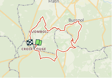
Tocht Stappen van 16,7 km beschikbaar op Wallonië, Luxemburg, Étalle. Deze tocht wordt voorgesteld door jeangulu.
Beschrijving
Point de départ : Parking de la Croix Rouge
Coordonnées : Latitude : 49°37'30.468" N
Longitude: 5°32'59.855" E
Plaatsbepaling
Land:
Belgium
Regio :
Wallonië
Departement/Provincie :
Luxemburg
Gemeente :
Étalle
Locatie:
Sainte-Marie
Vertrek:(Dec)
Vertrek:(UTM)
684154 ; 5500073 (31U) N.
Opmerkingen
Wandeltochten in de omgeving
![Tocht Stappen Virton - GAUME Balade naturelle et historique - Photo](https://media.geolcdn.com/t/375/260/ext.jpg?maxdim=2&url=https%3A%2F%2Fservices.sitytrail.com%2FGeolivesWS%2FDownloadMedia.ashx%3FTrailID%3D164521%26Media%3D20121125163840.jpeg)
![Stappen Stappen](https://static1.geolcdn.com/sitytour/trail-icons/101.png)
GAUME Balade naturelle et historique
Stappen
Heel gemakkelijk
(1)
Virton,
Wallonië,
Luxemburg,
Belgium
![](/images/other/stat-length.png)
5,2 km | 6,8 km-effort
1h 16min
![](https://static1.geolcdn.com/siteimages/upload/files/16400158638029165_repeat_loop_refresh_sync_direction_icon.png)
Ja
![Tocht Stappen Tintigny - À l’ombre de la forêt gaumaise - Photo](https://media.geolcdn.com/t/375/260/986c7bad-e287-4939-909a-6f941fb4d982.jpg&format=jpg&maxdim=2)
![Stappen Stappen](https://static1.geolcdn.com/sitytour/trail-icons/101.png)
À l’ombre de la forêt gaumaise
Stappen
Gemakkelijk
(4)
Tintigny,
Wallonië,
Luxemburg,
Belgium
![](/images/other/stat-length.png)
14,6 km | 17 km-effort
2h 49min
![](https://static1.geolcdn.com/siteimages/upload/files/16400158638029165_repeat_loop_refresh_sync_direction_icon.png)
Ja
![Tocht Stappen Tintigny - La Rando du Bian: Autour de Lahage - Photo](https://media.geolcdn.com/t/375/260/0375adaf-9b4d-45ec-8668-73d72fc0e5ca.jpg&format=jpg&maxdim=2)
![Stappen Stappen](https://static1.geolcdn.com/sitytour/trail-icons/101.png)
La Rando du Bian: Autour de Lahage
Stappen
Gemakkelijk
(1)
Tintigny,
Wallonië,
Luxemburg,
Belgium
![](/images/other/stat-length.png)
18,8 km | 22 km-effort
3h 58min
![](https://static1.geolcdn.com/siteimages/upload/files/16400158638029165_repeat_loop_refresh_sync_direction_icon.png)
Ja
![Tocht Mountainbike Étalle - O2bikers_26_etalle - Photo](https://media.geolcdn.com/t/375/260/ext.jpg?maxdim=2&url=https%3A%2F%2Fstatic1.geolcdn.com%2Fsiteimages%2Fupload%2Ffiles%2F1524743154velo.jpg)
![Mountainbike Mountainbike](https://static1.geolcdn.com/sitytour/trail-icons/202.png)
O2bikers_26_etalle
Mountainbike
Heel gemakkelijk
(1)
Étalle,
Wallonië,
Luxemburg,
Belgium
![](/images/other/stat-length.png)
22 km | 27 km-effort
3h 0min
![](https://static1.geolcdn.com/siteimages/upload/files/16400158638029165_repeat_loop_refresh_sync_direction_icon.png)
Ja
![Tocht Stappen Virton - Buzenol - Circuit Natura 2000, des sites qui valent le détour - Lx17 - Photo](https://media.geolcdn.com/t/375/260/ext.jpg?maxdim=2&url=https%3A%2F%2Fservices.sitytrail.com%2FGeolivesWS%2FDownloadMedia.ashx%3FTrailID%3D434845%26Media%3Dffe101bc-fd35-4310-a917-20a586f102b3.JPG)
![Stappen Stappen](https://static1.geolcdn.com/sitytour/trail-icons/101.png)
Buzenol - Circuit Natura 2000, des sites qui valent le détour - Lx17
Stappen
Medium
(1)
Virton,
Wallonië,
Luxemburg,
Belgium
![](/images/other/stat-length.png)
13,5 km | 16,7 km-effort
2h 0min
![](https://static1.geolcdn.com/siteimages/upload/files/16400158638029165_repeat_loop_refresh_sync_direction_icon.png)
Ja
![Tocht Te voet Étalle - La Fratinotte - Photo](https://media.geolcdn.com/t/375/260/ext.jpg?maxdim=2&url=https%3A%2F%2Fpivotmedia.tourismewallonie.be%2FOTH-A0-006F-0W6H%2FOTH-A0-006F-0W6H.jpg)
![Te voet Te voet](https://static1.geolcdn.com/sitytour/trail-icons/100.png)
La Fratinotte
Te voet
Gemakkelijk
Étalle,
Wallonië,
Luxemburg,
Belgium
![](/images/other/stat-length.png)
5,4 km | 6,1 km-effort
1h 23min
![](https://static1.geolcdn.com/siteimages/upload/files/16400158638029165_repeat_loop_refresh_sync_direction_icon.png)
Ja
![Tocht Stappen Tintigny - Bellefontaine, Gros Cron, Baraque Payat - Photo](https://media.geolcdn.com/t/375/260/6add515d-9069-4041-b983-a40bd7d1411c.jpg&format=jpg&maxdim=2)
![Stappen Stappen](https://static1.geolcdn.com/sitytour/trail-icons/101.png)
Bellefontaine, Gros Cron, Baraque Payat
Stappen
Medium
Tintigny,
Wallonië,
Luxemburg,
Belgium
![](/images/other/stat-length.png)
19,2 km | 23 km-effort
4h 56min
![](https://static1.geolcdn.com/siteimages/upload/files/16400158638029165_repeat_loop_refresh_sync_direction_icon.png)
Ja
![Tocht Stappen Étalle - Buzenol Montauban(bas) Buzenol - Photo](https://media.geolcdn.com/t/375/260/44178d24-693b-46fb-8f38-67ee5d66362e.jpg&format=jpg&maxdim=2)
![Stappen Stappen](https://static1.geolcdn.com/sitytour/trail-icons/101.png)
Buzenol Montauban(bas) Buzenol
Stappen
Medium
(1)
Étalle,
Wallonië,
Luxemburg,
Belgium
![](/images/other/stat-length.png)
10,8 km | 13,4 km-effort
1h 43min
![](https://static1.geolcdn.com/siteimages/upload/files/16400158638029165_repeat_loop_refresh_sync_direction_icon.png)
Ja
![Tocht Stappen Virton - Virton belle vue 8km 2020 - Photo](https://media.geolcdn.com/t/375/260/ext.jpg?maxdim=2&url=https%3A%2F%2Fstatic1.geolcdn.com%2Fsiteimages%2Fupload%2Ffiles%2F1553511878bg_sport_marche.png)
![Stappen Stappen](https://static1.geolcdn.com/sitytour/trail-icons/101.png)
Virton belle vue 8km 2020
Stappen
Gemakkelijk
(2)
Virton,
Wallonië,
Luxemburg,
Belgium
![](/images/other/stat-length.png)
8,7 km | 11 km-effort
2h 5min
![](https://static1.geolcdn.com/siteimages/upload/files/16400158638029165_repeat_loop_refresh_sync_direction_icon.png)
Ja