![](/images/other/stat-length.png)
![Tocht Mountainbike Saint-Zacharie - St zacharie - la Foux - la Jolie - Ermitage de st Jean du puy - le Regagnas - Le moulin de redon - Photo](https://media.geolcdn.com/t/1900/400/3d66c3b8-b4a5-48d5-b384-0acc461e4e5a.jpg&format=pjpeg&maxdim=2)
St zacharie - la Foux - la Jolie - Ermitage de st Jean du puy - le Regagnas - Le moulin de redon
marsupio
Gebruiker
![Lengte](/images/other/stat-length.png)
Lengte
26 km
![Max. hoogte](https://static1.geolcdn.com/siteimages/upload/files/1508320355ic_sort_altitude_max_24dp.png)
Max. hoogte
704 m
![Positief hoogteverschil](https://static1.geolcdn.com/siteimages/upload/files/1508320355ic_sort_den_pos_24dp.png)
Positief hoogteverschil
756 m
![Km-Effort](/images/other/stat-length.png)
Km-Effort
36 km
![Min. hoogte](https://static1.geolcdn.com/siteimages/upload/files/1508320355ic_sort_altitude_min_24dp.png)
Min. hoogte
233 m
![Negatief hoogteverschil](https://static1.geolcdn.com/siteimages/upload/files/1508320355ic_sort_den_neg_24dp.png)
Negatief hoogteverschil
754 m
![Boucle](https://static1.geolcdn.com/siteimages/upload/files/16400158638029165_repeat_loop_refresh_sync_direction_icon.png)
Boucle
Ja
Datum van aanmaak :
2021-05-15 07:07:28.829
Laatste wijziging :
2021-05-15 14:13:21.336
![Mountainbike](https://static1.geolcdn.com/sitytour/trail-icons/202.png)
2h42
Moeilijkheid : Moeilijk
![Scan deze QR-code om de tocht te openen in de SityTrail-applicatie](https://capi.geolives.com/qq0zvz2zws4bq2lad0pu/sitytour/trails/2787580/qr.png?size=200)
Gratisgps-wandelapplicatie
Over ons
Tocht Mountainbike van 26 km beschikbaar op Provence-Alpes-Côte d'Azur, Var, Saint-Zacharie. Deze tocht wordt voorgesteld door marsupio.
Beschrijving
Difficile surtout la descente du Regagnas ou un vélo de descente est souhaitable et une certaine pratique de la dissipline est indispensable !
Plaatsbepaling
Land:
France
Regio :
Provence-Alpes-Côte d'Azur
Departement/Provincie :
Var
Gemeente :
Saint-Zacharie
Locatie:
Unknown
Vertrek:(Dec)
Vertrek:(UTM)
719448 ; 4807727 (31T) N.
Opmerkingen
Wandeltochten in de omgeving
![Tocht Mountainbike Trets - les contreforts du mont Olympe - Photo](https://media.geolcdn.com/t/375/260/ext.jpg?maxdim=2&url=https%3A%2F%2Fservices.sitytrail.com%2FGeolivesWS%2FDownloadMedia.ashx%3FTrailID%3D675672%26Media%3Dfix__20161223150806.jpg)
![Mountainbike Mountainbike](https://static1.geolcdn.com/sitytour/trail-icons/202.png)
les contreforts du mont Olympe
Mountainbike
Gemakkelijk
(1)
Trets,
Provence-Alpes-Côte d'Azur,
Bouches-du-Rhône,
France
![](/images/other/stat-length.png)
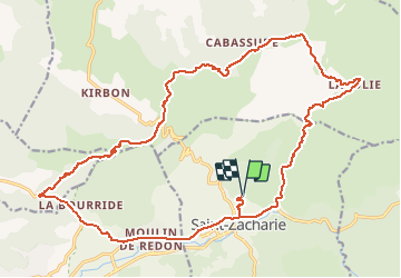
11,8 km | 15,5 km-effort
2h 52min
![](https://static1.geolcdn.com/siteimages/upload/files/16400158638029165_repeat_loop_refresh_sync_direction_icon.png)
Ja
![Tocht Stappen Auriol - la crete des infernets - Photo](https://media.geolcdn.com/t/375/260/ext.jpg?maxdim=2&url=https%3A%2F%2Fservices.sitytrail.com%2FGeolivesWS%2FDownloadMedia.ashx%3FTrailID%3D867921%26Media%3Dfix__20171126111949.jpg)
![Stappen Stappen](https://static1.geolcdn.com/sitytour/trail-icons/101.png)
la crete des infernets
Stappen
Moeilijk
(1)
Auriol,
Provence-Alpes-Côte d'Azur,
Bouches-du-Rhône,
France
![](/images/other/stat-length.png)
8,6 km | 14 km-effort
3h 22min
![](https://static1.geolcdn.com/siteimages/upload/files/16400158638029165_repeat_loop_refresh_sync_direction_icon.png)
Ja
![Tocht Stappen Saint-Zacharie - Sources des Nayes - Photo](https://media.geolcdn.com/t/375/260/f10876bf-7b9c-4295-a050-83953c85f7a8.jpg&format=jpg&maxdim=2)
![Stappen Stappen](https://static1.geolcdn.com/sitytour/trail-icons/101.png)
Sources des Nayes
Stappen
Medium
Saint-Zacharie,
Provence-Alpes-Côte d'Azur,
Var,
France
![](/images/other/stat-length.png)
7,6 km | 9,6 km-effort
1h 47min
![](https://static1.geolcdn.com/siteimages/upload/files/16400158638029165_repeat_loop_refresh_sync_direction_icon.png)
Ja
![Tocht Stappen Auriol - le ravin des Encanaux - Photo](https://media.geolcdn.com/t/375/260/0d6477e8-e2d8-4d99-b893-ff8f37b49a9c.jpg&format=jpg&maxdim=2)
![Stappen Stappen](https://static1.geolcdn.com/sitytour/trail-icons/101.png)
le ravin des Encanaux
Stappen
Moeilijk
Auriol,
Provence-Alpes-Côte d'Azur,
Bouches-du-Rhône,
France
![](/images/other/stat-length.png)
7,3 km | 12,2 km-effort
3h 10min
![](https://static1.geolcdn.com/siteimages/upload/files/16400158638029165_repeat_loop_refresh_sync_direction_icon.png)
Ja
![Tocht Stappen Saint-Zacharie - Source de l'Huveaune - Photo](https://media.geolcdn.com/t/375/260/ext.jpg?maxdim=2&url=https%3A%2F%2Fservices.sitytrail.com%2FGeolivesWS%2FDownloadMedia.ashx%3FTrailID%3D393138%26Media%3Dfix__20150307141431.jpg)
![Stappen Stappen](https://static1.geolcdn.com/sitytour/trail-icons/101.png)
Source de l'Huveaune
Stappen
Gemakkelijk
Saint-Zacharie,
Provence-Alpes-Côte d'Azur,
Var,
France
![](/images/other/stat-length.png)
15,2 km | 19,7 km-effort
4h 24min
![](https://static1.geolcdn.com/siteimages/upload/files/16400158638029165_repeat_loop_refresh_sync_direction_icon.png)
Ja
![Tocht Stappen Auriol - Les Encanaux, Auriol-05-06-24 - Photo](https://media.geolcdn.com/t/375/260/4f585078-9323-4b69-b9ad-98d39eead66e.jpg&format=jpg&maxdim=2)
![Stappen Stappen](https://static1.geolcdn.com/sitytour/trail-icons/101.png)
Les Encanaux, Auriol-05-06-24
Stappen
Medium
Auriol,
Provence-Alpes-Côte d'Azur,
Bouches-du-Rhône,
France
![](/images/other/stat-length.png)
15,4 km | 24 km-effort
4h 9min
![](https://static1.geolcdn.com/siteimages/upload/files/16400158638029165_repeat_loop_refresh_sync_direction_icon.png)
Ja
![Tocht Stappen Auriol - les Encanaux - Photo](https://media.geolcdn.com/t/375/260/3bba590b-d41b-4fbd-a3a9-76850bb610aa.jpg&format=jpg&maxdim=2)
![Stappen Stappen](https://static1.geolcdn.com/sitytour/trail-icons/101.png)
les Encanaux
Stappen
Moeilijk
Auriol,
Provence-Alpes-Côte d'Azur,
Bouches-du-Rhône,
France
![](/images/other/stat-length.png)
7,1 km | 11 km-effort
2h 14min
![](https://static1.geolcdn.com/siteimages/upload/files/16400158638029165_repeat_loop_refresh_sync_direction_icon.png)
Ja
![Tocht Stappen Auriol - Ravin des Infernets -Tête de chien - Photo](https://media.geolcdn.com/t/375/260/87e67d84-cabc-4812-80f4-0f6a5c04faa5.jpg&format=jpg&maxdim=2)
![Stappen Stappen](https://static1.geolcdn.com/sitytour/trail-icons/101.png)
Ravin des Infernets -Tête de chien
Stappen
Zeer moeilijk
Auriol,
Provence-Alpes-Côte d'Azur,
Bouches-du-Rhône,
France
![](/images/other/stat-length.png)
13,7 km | 22 km-effort
9h 33min
![](https://static1.geolcdn.com/siteimages/upload/files/16400158638029165_repeat_loop_refresh_sync_direction_icon.png)
Ja
![Tocht Stappen Auriol - les Encanaux - Photo](https://media.geolcdn.com/t/375/260/3618d49d-f0c1-4cb3-91c5-cf316631a9da.jpg&format=jpg&maxdim=2)
![Stappen Stappen](https://static1.geolcdn.com/sitytour/trail-icons/101.png)
les Encanaux
Stappen
Medium
(1)
Auriol,
Provence-Alpes-Côte d'Azur,
Bouches-du-Rhône,
France
![](/images/other/stat-length.png)
12,5 km | 21 km-effort
4h 51min
![](https://static1.geolcdn.com/siteimages/upload/files/16400158638029165_repeat_loop_refresh_sync_direction_icon.png)
Ja