![](/images/other/stat-length.png)
![Tocht Stappen Le Cellier - Les sillons de Le Cellier -13,5 km - Photo](https://media.geolcdn.com/t/1900/400/da3b9a92-d7c5-4831-92ed-9f0b93c284fc.jpg&format=pjpeg&maxdim=2)
Les sillons de Le Cellier -13,5 km
Lobin
Gebruiker
![Lengte](/images/other/stat-length.png)
Lengte
13,5 km
![Max. hoogte](https://static1.geolcdn.com/siteimages/upload/files/1508320355ic_sort_altitude_max_24dp.png)
Max. hoogte
84 m
![Positief hoogteverschil](https://static1.geolcdn.com/siteimages/upload/files/1508320355ic_sort_den_pos_24dp.png)
Positief hoogteverschil
258 m
![Km-Effort](/images/other/stat-length.png)
Km-Effort
17 km
![Min. hoogte](https://static1.geolcdn.com/siteimages/upload/files/1508320355ic_sort_altitude_min_24dp.png)
Min. hoogte
4 m
![Negatief hoogteverschil](https://static1.geolcdn.com/siteimages/upload/files/1508320355ic_sort_den_neg_24dp.png)
Negatief hoogteverschil
256 m
![Boucle](https://static1.geolcdn.com/siteimages/upload/files/16400158638029165_repeat_loop_refresh_sync_direction_icon.png)
Boucle
Ja
Datum van aanmaak :
2021-05-08 13:11:28.0
Laatste wijziging :
2021-05-08 20:07:21.485
![Stappen](https://static1.geolcdn.com/sitytour/trail-icons/101.png)
6h55
Moeilijkheid : Medium
![Scan deze QR-code om de tocht te openen in de SityTrail-applicatie](https://capi.geolives.com/qq0zvz2zws4bq2lad0pu/sitytour/trails/2778544/qr.png?size=200)
Gratisgps-wandelapplicatie
Over ons
Tocht Stappen van 13,5 km beschikbaar op Pays de la Loire, Loire-Atlantique, Le Cellier. Deze tocht wordt voorgesteld door Lobin.
Beschrijving
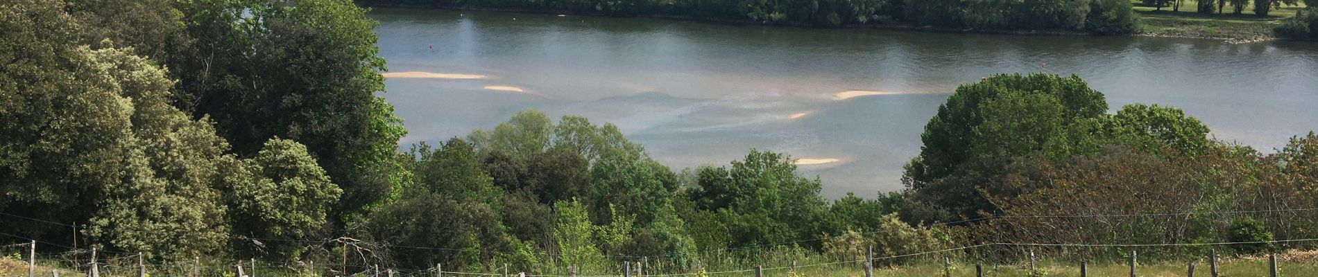
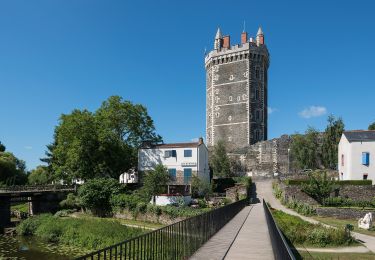
Belle randonnée avec de belles vues sur la Loire et de très beaux châteaux tout au long de la balade en finissant par les coulées superbes
Plaatsbepaling
Land:
France
Regio :
Pays de la Loire
Departement/Provincie :
Loire-Atlantique
Gemeente :
Le Cellier
Locatie:
Unknown
Vertrek:(Dec)
Vertrek:(UTM)
624895 ; 5241963 (30T) N.
Opmerkingen
Wandeltochten in de omgeving
![Tocht Te voet Divatte-sur-Loire - La Haute Chapelle - Photo](https://media.geolcdn.com/t/375/260/93d8b1e6-c5d6-459b-908b-9d25edfc7517.jpeg&format=jpg&maxdim=2)
![Te voet Te voet](https://static1.geolcdn.com/sitytour/trail-icons/100.png)
La Haute Chapelle
Te voet
Gemakkelijk
Divatte-sur-Loire,
Pays de la Loire,
Loire-Atlantique,
France
![](/images/other/stat-length.png)
10,5 km | 12,4 km-effort
2h 48min
![](https://static1.geolcdn.com/siteimages/upload/files/16400158638029165_repeat_loop_refresh_sync_direction_icon.png)
Neen
![Tocht Te voet Divatte-sur-Loire - La Haute Chapelle (variante) - Photo](https://media.geolcdn.com/t/375/260/93d8b1e6-c5d6-459b-908b-9d25edfc7517.jpeg&format=jpg&maxdim=2)
![Te voet Te voet](https://static1.geolcdn.com/sitytour/trail-icons/100.png)
La Haute Chapelle (variante)
Te voet
Gemakkelijk
Divatte-sur-Loire,
Pays de la Loire,
Loire-Atlantique,
France
![](/images/other/stat-length.png)
9,3 km | 10,7 km-effort
2h 26min
![](https://static1.geolcdn.com/siteimages/upload/files/16400158638029165_repeat_loop_refresh_sync_direction_icon.png)
Neen
![Tocht Te voet Saint-Mars-du-Désert - Au détour des Moulins - Photo](https://media.geolcdn.com/t/375/260/3ead951d-31fb-47cb-93e2-d81cad18a025.jpeg&format=jpg&maxdim=2)
![Te voet Te voet](https://static1.geolcdn.com/sitytour/trail-icons/100.png)
Au détour des Moulins
Te voet
Gemakkelijk
Saint-Mars-du-Désert,
Pays de la Loire,
Loire-Atlantique,
France
![](/images/other/stat-length.png)
11,5 km | 12,8 km-effort
2h 55min
![](https://static1.geolcdn.com/siteimages/upload/files/16400158638029165_repeat_loop_refresh_sync_direction_icon.png)
Neen
![Tocht Te voet Saint-Mars-du-Désert - L'Orée du Bois - Photo](https://media.geolcdn.com/t/375/260/3ead951d-31fb-47cb-93e2-d81cad18a025.jpeg&format=jpg&maxdim=2)
![Te voet Te voet](https://static1.geolcdn.com/sitytour/trail-icons/100.png)
L'Orée du Bois
Te voet
Gemakkelijk
Saint-Mars-du-Désert,
Pays de la Loire,
Loire-Atlantique,
France
![](/images/other/stat-length.png)
9,1 km | 9,7 km-effort
2h 12min
![](https://static1.geolcdn.com/siteimages/upload/files/16400158638029165_repeat_loop_refresh_sync_direction_icon.png)
Neen
![Tocht Stappen Divatte-sur-Loire - La Chapelle-Basse-Mer - nord-ouest - Photo](https://media.geolcdn.com/t/375/260/ext.jpg?maxdim=2&url=https%3A%2F%2Fstatic1.geolcdn.com%2Fsiteimages%2Fupload%2Ffiles%2F1553511878bg_sport_marche.png)
![Stappen Stappen](https://static1.geolcdn.com/sitytour/trail-icons/101.png)
La Chapelle-Basse-Mer - nord-ouest
Stappen
Gemakkelijk
(1)
Divatte-sur-Loire,
Pays de la Loire,
Loire-Atlantique,
France
![](/images/other/stat-length.png)
9,1 km | 9,6 km-effort
2h 8min
![](https://static1.geolcdn.com/siteimages/upload/files/16400158638029165_repeat_loop_refresh_sync_direction_icon.png)
Ja
![Tocht Te voet Oudon - PR la vallée du Havre - Photo](https://media.geolcdn.com/t/375/260/33940d66-f465-4229-a313-ac42721d042d.jpeg&format=jpg&maxdim=2)
![Te voet Te voet](https://static1.geolcdn.com/sitytour/trail-icons/100.png)
PR la vallée du Havre
Te voet
Gemakkelijk
Oudon,
Pays de la Loire,
Loire-Atlantique,
France
![](/images/other/stat-length.png)
6 km | 6,9 km-effort
1h 33min
![](https://static1.geolcdn.com/siteimages/upload/files/16400158638029165_repeat_loop_refresh_sync_direction_icon.png)
Ja
![Tocht Stappen Oudon - Les bords de Loire entre Oudon et Ancenis - Photo](https://media.geolcdn.com/t/375/260/ext.jpg?maxdim=2&url=https%3A%2F%2Fservices.sitytrail.com%2FGeolivesWS%2FDownloadMedia.ashx%3FTrailID%3D106913%26Media%3D11674_6.jpg)
![Stappen Stappen](https://static1.geolcdn.com/sitytour/trail-icons/101.png)
Les bords de Loire entre Oudon et Ancenis
Stappen
Medium
Oudon,
Pays de la Loire,
Loire-Atlantique,
France
![](/images/other/stat-length.png)
22 km | 24 km-effort
5h 0min
![](https://static1.geolcdn.com/siteimages/upload/files/16400158638029165_repeat_loop_refresh_sync_direction_icon.png)
Ja
![Tocht Stappen Le Cellier - Le Cellier 2011-05-22 - Photo](https://media.geolcdn.com/t/375/260/ext.jpg?maxdim=2&url=https%3A%2F%2Fstatic1.geolcdn.com%2Fsiteimages%2Fupload%2Ffiles%2F1553511878bg_sport_marche.png)
![Stappen Stappen](https://static1.geolcdn.com/sitytour/trail-icons/101.png)
Le Cellier 2011-05-22
Stappen
Gemakkelijk
(2)
Le Cellier,
Pays de la Loire,
Loire-Atlantique,
France
![](/images/other/stat-length.png)
16,4 km | 19,9 km-effort
Onbekend
![](https://static1.geolcdn.com/siteimages/upload/files/16400158638029165_repeat_loop_refresh_sync_direction_icon.png)
Ja
![Tocht Stappen Le Cellier - Cellier Coulées Clermont - Photo](https://media.geolcdn.com/t/375/260/2361c700-00a0-4a31-87db-f571e08954ff.jpg&format=jpg&maxdim=2)
![Stappen Stappen](https://static1.geolcdn.com/sitytour/trail-icons/101.png)
Cellier Coulées Clermont
Stappen
Medium
Le Cellier,
Pays de la Loire,
Loire-Atlantique,
France
![](/images/other/stat-length.png)
8,4 km | 10,5 km-effort
2h 25min
![](https://static1.geolcdn.com/siteimages/upload/files/16400158638029165_repeat_loop_refresh_sync_direction_icon.png)
Ja