![](/images/other/stat-length.png)
![Tocht Stappen Les Trois Lacs - Venables coteaux - Photo](https://media.geolcdn.com/t/1900/400/ext.pjpeg?maxdim=2&url=https%3A%2F%2Fstatic1.geolcdn.com%2Fsiteimages%2Fupload%2Ffiles%2F1553511878bg_sport_marche.png)
Venables coteaux
mykeluce
Gebruiker
![Lengte](/images/other/stat-length.png)
Lengte
10,5 km
![Max. hoogte](https://static1.geolcdn.com/siteimages/upload/files/1508320355ic_sort_altitude_max_24dp.png)
Max. hoogte
134 m
![Positief hoogteverschil](https://static1.geolcdn.com/siteimages/upload/files/1508320355ic_sort_den_pos_24dp.png)
Positief hoogteverschil
210 m
![Km-Effort](/images/other/stat-length.png)
Km-Effort
13,5 km
![Min. hoogte](https://static1.geolcdn.com/siteimages/upload/files/1508320355ic_sort_altitude_min_24dp.png)
Min. hoogte
6 m
![Negatief hoogteverschil](https://static1.geolcdn.com/siteimages/upload/files/1508320355ic_sort_den_neg_24dp.png)
Negatief hoogteverschil
256 m
![Boucle](https://static1.geolcdn.com/siteimages/upload/files/16400158638029165_repeat_loop_refresh_sync_direction_icon.png)
Boucle
Neen
Datum van aanmaak :
2021-05-08 13:43:28.0
Laatste wijziging :
2021-05-08 16:41:03.565
![Stappen](https://static1.geolcdn.com/sitytour/trail-icons/101.png)
2h57
Moeilijkheid : Medium
![Scan deze QR-code om de tocht te openen in de SityTrail-applicatie](https://capi.geolives.com/qq0zvz2zws4bq2lad0pu/sitytour/trails/2778231/qr.png?size=200)
Gratisgps-wandelapplicatie
Over ons
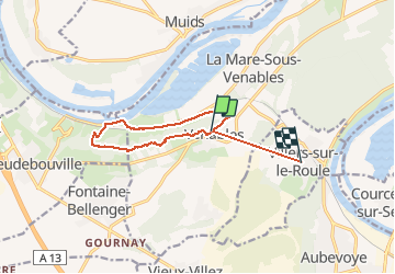
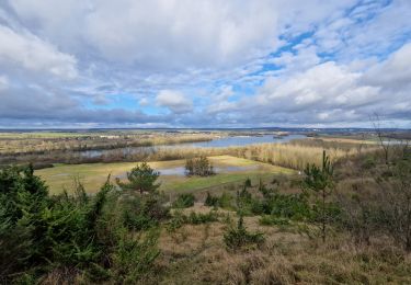
Tocht Stappen van 10,5 km beschikbaar op Normandië, Eure, Les Trois Lacs. Deze tocht wordt voorgesteld door mykeluce.
Beschrijving
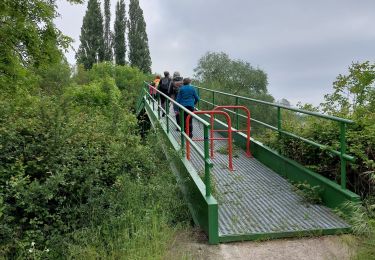
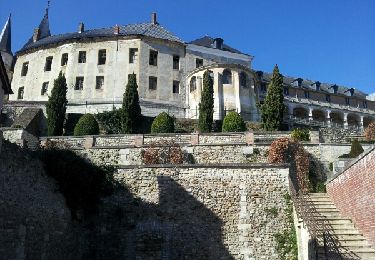
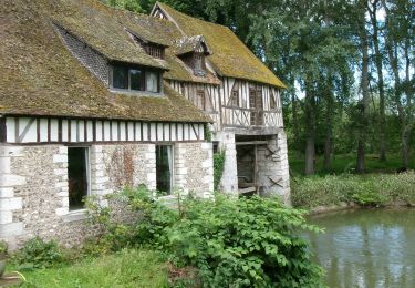
Partir de venables Faire les coteaux jusqu’à dépasser les moulins à vent. Continuer puis descendre sur le Prieuré de Lormais. Chemin de halage et remonter pour récupérer le chemin longeant la voie ferrée. Fin du trajet par la route.
Plaatsbepaling
Land:
France
Regio :
Normandië
Departement/Provincie :
Eure
Gemeente :
Les Trois Lacs
Locatie:
Unknown
Vertrek:(Dec)
Vertrek:(UTM)
375905 ; 5451104 (31U) N.
Opmerkingen
Wandeltochten in de omgeving
![Tocht Stappen Herqueville - Daniel - Photo](https://media.geolcdn.com/t/375/260/ext.jpg?maxdim=2&url=https%3A%2F%2Fstatic1.geolcdn.com%2Fsiteimages%2Fupload%2Ffiles%2F1553511878bg_sport_marche.png)
![Stappen Stappen](https://static1.geolcdn.com/sitytour/trail-icons/101.png)
Daniel
Stappen
Heel gemakkelijk
(2)
Herqueville,
Normandië,
Eure,
France
![](/images/other/stat-length.png)
9,8 km | 11,2 km-effort
2h 40min
![](https://static1.geolcdn.com/siteimages/upload/files/16400158638029165_repeat_loop_refresh_sync_direction_icon.png)
Ja
![Tocht Stappen Les Trois Lacs - rando venables - Photo](https://media.geolcdn.com/t/375/260/22618f54-a99a-400a-9f80-970e6ccaa126.jpg&format=jpg&maxdim=2)
![Stappen Stappen](https://static1.geolcdn.com/sitytour/trail-icons/101.png)
rando venables
Stappen
Medium
Les Trois Lacs,
Normandië,
Eure,
France
![](/images/other/stat-length.png)
10,9 km | 13,1 km-effort
3h 2min
![](https://static1.geolcdn.com/siteimages/upload/files/16400158638029165_repeat_loop_refresh_sync_direction_icon.png)
Ja
![Tocht Stappen Heudebouville - 20230202-Heudebouville - Photo](https://media.geolcdn.com/t/375/260/9a040f26-251c-4887-9b11-b6efcdf3ee8d.jpg&format=jpg&maxdim=2)
![Stappen Stappen](https://static1.geolcdn.com/sitytour/trail-icons/101.png)
20230202-Heudebouville
Stappen
Medium
Heudebouville,
Normandië,
Eure,
France
![](/images/other/stat-length.png)
12,1 km | 15,1 km-effort
3h 55min
![](https://static1.geolcdn.com/siteimages/upload/files/16400158638029165_repeat_loop_refresh_sync_direction_icon.png)
Ja
![Tocht Stappen Gaillon - Gaillon-StAubin-Brillehaut - Photo](https://media.geolcdn.com/t/375/260/ext.jpg?maxdim=2&url=https%3A%2F%2Fservices.sitytrail.com%2FGeolivesWS%2FDownloadMedia.ashx%3FTrailID%3D254321%26Media%3D0ff5fe82-437c-49ce-957a-1ddcf2ccee08.jpg)
![Stappen Stappen](https://static1.geolcdn.com/sitytour/trail-icons/101.png)
Gaillon-StAubin-Brillehaut
Stappen
Medium
Gaillon,
Normandië,
Eure,
France
![](/images/other/stat-length.png)
11,3 km | 14,7 km-effort
3h 9min
![](https://static1.geolcdn.com/siteimages/upload/files/16400158638029165_repeat_loop_refresh_sync_direction_icon.png)
Ja
![Tocht Stappen Ailly - Ailly-AtraversPlateauMadrie_14Km - Photo](https://media.geolcdn.com/t/375/260/ext.jpg?maxdim=2&url=https%3A%2F%2Fservices.sitytrail.com%2FGeolivesWS%2FDownloadMedia.ashx%3FTrailID%3D235366%26Media%3De686680b-3665-4290-b0cf-e061374a377a.jpg)
![Stappen Stappen](https://static1.geolcdn.com/sitytour/trail-icons/101.png)
Ailly-AtraversPlateauMadrie_14Km
Stappen
Gemakkelijk
Ailly,
Normandië,
Eure,
France
![](/images/other/stat-length.png)
14,1 km | 16 km-effort
3h 30min
![](https://static1.geolcdn.com/siteimages/upload/files/16400158638029165_repeat_loop_refresh_sync_direction_icon.png)
Ja
![Tocht Stappen Villers-sur-le-Roule - Villers-Venables_13Km - Photo](https://media.geolcdn.com/t/375/260/ext.jpg?maxdim=2&url=https%3A%2F%2Fservices.sitytrail.com%2FGeolivesWS%2FDownloadMedia.ashx%3FTrailID%3D221913%26Media%3D7d41c3a5-5fff-4cf4-92c7-98d98d110dd1.jpg)
![Stappen Stappen](https://static1.geolcdn.com/sitytour/trail-icons/101.png)
Villers-Venables_13Km
Stappen
Medium
Villers-sur-le-Roule,
Normandië,
Eure,
France
![](/images/other/stat-length.png)
11,9 km | 14,9 km-effort
3h 10min
![](https://static1.geolcdn.com/siteimages/upload/files/16400158638029165_repeat_loop_refresh_sync_direction_icon.png)
Ja
![Stappen Stappen](https://static1.geolcdn.com/sitytour/trail-icons/101.png)
20240109-venables
Stappen
Medium
Les Trois Lacs,
Normandië,
Eure,
France
![](/images/other/stat-length.png)
8,9 km | 11 km-effort
2h 23min
![](https://static1.geolcdn.com/siteimages/upload/files/16400158638029165_repeat_loop_refresh_sync_direction_icon.png)
Ja
![Stappen Stappen](https://static1.geolcdn.com/sitytour/trail-icons/101.png)
20240611-Andé Cool
Stappen
Gemakkelijk
Andé,
Normandië,
Eure,
France
![](/images/other/stat-length.png)
8,6 km | 9,8 km-effort
2h 26min
![](https://static1.geolcdn.com/siteimages/upload/files/16400158638029165_repeat_loop_refresh_sync_direction_icon.png)
Ja
![Stappen Stappen](https://static1.geolcdn.com/sitytour/trail-icons/101.png)
20230627-Ande Cool
Stappen
Gemakkelijk
Andé,
Normandië,
Eure,
France
![](/images/other/stat-length.png)
9,7 km | 11,2 km-effort
2h 33min
![](https://static1.geolcdn.com/siteimages/upload/files/16400158638029165_repeat_loop_refresh_sync_direction_icon.png)
Ja