![](/images/other/stat-length.png)
![Tocht Stappen Morville-sur-Seille - Morville-sur-Seille, Eply, Raucourt 15 650m +153m - Photo](https://media.geolcdn.com/t/1900/400/ext.pjpeg?maxdim=2&url=https%3A%2F%2Fstatic1.geolcdn.com%2Fsiteimages%2Fupload%2Ffiles%2F1553511878bg_sport_marche.png)
Morville-sur-Seille, Eply, Raucourt 15 650m +153m
DanielROLLET
Gebruiker
![Lengte](/images/other/stat-length.png)
Lengte
15,6 km
![Max. hoogte](https://static1.geolcdn.com/siteimages/upload/files/1508320355ic_sort_altitude_max_24dp.png)
Max. hoogte
242 m
![Positief hoogteverschil](https://static1.geolcdn.com/siteimages/upload/files/1508320355ic_sort_den_pos_24dp.png)
Positief hoogteverschil
153 m
![Km-Effort](/images/other/stat-length.png)
Km-Effort
17,7 km
![Min. hoogte](https://static1.geolcdn.com/siteimages/upload/files/1508320355ic_sort_altitude_min_24dp.png)
Min. hoogte
174 m
![Negatief hoogteverschil](https://static1.geolcdn.com/siteimages/upload/files/1508320355ic_sort_den_neg_24dp.png)
Negatief hoogteverschil
153 m
![Boucle](https://static1.geolcdn.com/siteimages/upload/files/16400158638029165_repeat_loop_refresh_sync_direction_icon.png)
Boucle
Ja
Datum van aanmaak :
2021-05-07 07:30:07.728
Laatste wijziging :
2021-05-08 07:42:37.279
![Stappen](https://static1.geolcdn.com/sitytour/trail-icons/101.png)
4h30
Moeilijkheid : Moeilijk
![Scan deze QR-code om de tocht te openen in de SityTrail-applicatie](https://capi.geolives.com/qq0zvz2zws4bq2lad0pu/sitytour/trails/2776404/qr.png?size=200)
Gratisgps-wandelapplicatie
Over ons
Tocht Stappen van 15,6 km beschikbaar op Grand Est, Meurthe-et-Moselle, Morville-sur-Seille. Deze tocht wordt voorgesteld door DanielROLLET.
Beschrijving
2021 05 07 Reco balisage pour Rando 54 avec Marie.
Beau temps mais venteux et frais.
9h30 à 14h00
Plaatsbepaling
Land:
France
Regio :
Grand Est
Departement/Provincie :
Meurthe-et-Moselle
Gemeente :
Morville-sur-Seille
Locatie:
Unknown
Vertrek:(Dec)
Vertrek:(UTM)
291638 ; 5422145 (32U) N.
Opmerkingen
Wandeltochten in de omgeving
![Tocht Stappen Bouxières-sous-Froidmont - Arry - Photo](https://media.geolcdn.com/t/375/260/b9a2e719-0554-47d3-8506-0e3375a6076a.jpg&format=jpg&maxdim=2)
![Stappen Stappen](https://static1.geolcdn.com/sitytour/trail-icons/101.png)
Arry
Stappen
Medium
Bouxières-sous-Froidmont,
Grand Est,
Meurthe-et-Moselle,
France
![](/images/other/stat-length.png)
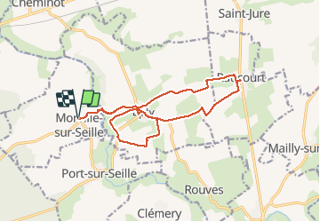
13,6 km | 18,3 km-effort
3h 28min
![](https://static1.geolcdn.com/siteimages/upload/files/16400158638029165_repeat_loop_refresh_sync_direction_icon.png)
Ja
![Tocht Stappen Belleau - Manoncourt sur seille - Photo](https://media.geolcdn.com/t/375/260/90d150fa-c70d-44e3-85c3-82721aab576a.jpg&format=jpg&maxdim=2)
![Stappen Stappen](https://static1.geolcdn.com/sitytour/trail-icons/101.png)
Manoncourt sur seille
Stappen
Gemakkelijk
Belleau,
Grand Est,
Meurthe-et-Moselle,
France
![](/images/other/stat-length.png)
9,5 km | 11,1 km-effort
4h 3min
![](https://static1.geolcdn.com/siteimages/upload/files/16400158638029165_repeat_loop_refresh_sync_direction_icon.png)
Ja
![Tocht Stappen Lesménils - Lesmenils - Le Xon - Photo](https://media.geolcdn.com/t/375/260/02f6c6d1-9212-4506-a980-6bbea0a2802b.jpg&format=jpg&maxdim=2)
![Stappen Stappen](https://static1.geolcdn.com/sitytour/trail-icons/101.png)
Lesmenils - Le Xon
Stappen
Gemakkelijk
Lesménils,
Grand Est,
Meurthe-et-Moselle,
France
![](/images/other/stat-length.png)
5 km | 6,9 km-effort
2h 10min
![](https://static1.geolcdn.com/siteimages/upload/files/16400158638029165_repeat_loop_refresh_sync_direction_icon.png)
Ja
![Tocht Stappen Éply - SC3 Circuit les Prés Bas 4 500m + 39m - Photo](https://media.geolcdn.com/t/375/260/ext.jpg?maxdim=2&url=https%3A%2F%2Fstatic1.geolcdn.com%2Fsiteimages%2Fupload%2Ffiles%2F1553511878bg_sport_marche.png)
![Stappen Stappen](https://static1.geolcdn.com/sitytour/trail-icons/101.png)
SC3 Circuit les Prés Bas 4 500m + 39m
Stappen
Gemakkelijk
Éply,
Grand Est,
Meurthe-et-Moselle,
France
![](/images/other/stat-length.png)
4,7 km | 5,3 km-effort
1h 3min
![](https://static1.geolcdn.com/siteimages/upload/files/16400158638029165_repeat_loop_refresh_sync_direction_icon.png)
Ja
![Tocht Stappen Bouxières-sous-Froidmont - Bouxières sous Froidmont - Photo](https://media.geolcdn.com/t/375/260/ext.jpg?maxdim=2&url=https%3A%2F%2Fstatic1.geolcdn.com%2Fsiteimages%2Fupload%2Ffiles%2F1553511878bg_sport_marche.png)
![Stappen Stappen](https://static1.geolcdn.com/sitytour/trail-icons/101.png)
Bouxières sous Froidmont
Stappen
Moeilijk
Bouxières-sous-Froidmont,
Grand Est,
Meurthe-et-Moselle,
France
![](/images/other/stat-length.png)
19,3 km | 26 km-effort
5h 26min
![](https://static1.geolcdn.com/siteimages/upload/files/16400158638029165_repeat_loop_refresh_sync_direction_icon.png)
Ja
![Tocht Hybride fiets Cheminot - Sort avec lola - Photo](https://media.geolcdn.com/t/375/260/ext.jpg?maxdim=2&url=https%3A%2F%2Fstatic1.geolcdn.com%2Fsiteimages%2Fupload%2Ffiles%2F1524743154velo.jpg)
![Hybride fiets Hybride fiets](https://static1.geolcdn.com/sitytour/trail-icons/203.png)
Sort avec lola
Hybride fiets
Gemakkelijk
Cheminot,
Grand Est,
Moselle,
France
![](/images/other/stat-length.png)
8,6 km | 9,3 km-effort
49min
![](https://static1.geolcdn.com/siteimages/upload/files/16400158638029165_repeat_loop_refresh_sync_direction_icon.png)
Ja
![Tocht Mountainbike Cheminot - Autour de Cheminot - Photo](https://media.geolcdn.com/t/375/260/ext.jpg?maxdim=2&url=https%3A%2F%2Fstatic1.geolcdn.com%2Fsiteimages%2Fupload%2Ffiles%2F1524743154velo.jpg)
![Mountainbike Mountainbike](https://static1.geolcdn.com/sitytour/trail-icons/202.png)
Autour de Cheminot
Mountainbike
Zeer moeilijk
Cheminot,
Grand Est,
Moselle,
France
![](/images/other/stat-length.png)
44 km | 52 km-effort
3h 29min
![](https://static1.geolcdn.com/siteimages/upload/files/16400158638029165_repeat_loop_refresh_sync_direction_icon.png)
Neen
![Tocht Stappen Lesménils - Xon - Lesmenils - Photo](https://media.geolcdn.com/t/375/260/ext.jpg?maxdim=2&url=https%3A%2F%2Fstatic1.geolcdn.com%2Fsiteimages%2Fupload%2Ffiles%2F1553511878bg_sport_marche.png)
![Stappen Stappen](https://static1.geolcdn.com/sitytour/trail-icons/101.png)
Xon - Lesmenils
Stappen
Medium
Lesménils,
Grand Est,
Meurthe-et-Moselle,
France
![](/images/other/stat-length.png)
11,7 km | 15,9 km-effort
3h 36min
![](https://static1.geolcdn.com/siteimages/upload/files/16400158638029165_repeat_loop_refresh_sync_direction_icon.png)
Ja
![Tocht Stappen Lesménils - 9183123-Xon et forêt de Facq - Photo](https://media.geolcdn.com/t/375/260/ext.jpg?maxdim=2&url=https%3A%2F%2Fstatic1.geolcdn.com%2Fsiteimages%2Fupload%2Ffiles%2F1553511878bg_sport_marche.png)
![Stappen Stappen](https://static1.geolcdn.com/sitytour/trail-icons/101.png)
9183123-Xon et forêt de Facq
Stappen
Moeilijk
(1)
Lesménils,
Grand Est,
Meurthe-et-Moselle,
France
![](/images/other/stat-length.png)
10,3 km | 13,2 km-effort
3h 0min
![](https://static1.geolcdn.com/siteimages/upload/files/16400158638029165_repeat_loop_refresh_sync_direction_icon.png)
Ja