![](/images/other/stat-length.png)
![Tocht Stappen Darnets - Darnets-luzège - Photo](https://media.geolcdn.com/t/1900/400/ext.pjpeg?maxdim=2&url=https%3A%2F%2Fstatic1.geolcdn.com%2Fsiteimages%2Fupload%2Ffiles%2F1553511878bg_sport_marche.png)
Darnets-luzège
fanclem
Gebruiker
![Lengte](/images/other/stat-length.png)
Lengte
13,2 km
![Max. hoogte](https://static1.geolcdn.com/siteimages/upload/files/1508320355ic_sort_altitude_max_24dp.png)
Max. hoogte
634 m
![Positief hoogteverschil](https://static1.geolcdn.com/siteimages/upload/files/1508320355ic_sort_den_pos_24dp.png)
Positief hoogteverschil
282 m
![Km-Effort](/images/other/stat-length.png)
Km-Effort
16,9 km
![Min. hoogte](https://static1.geolcdn.com/siteimages/upload/files/1508320355ic_sort_altitude_min_24dp.png)
Min. hoogte
531 m
![Negatief hoogteverschil](https://static1.geolcdn.com/siteimages/upload/files/1508320355ic_sort_den_neg_24dp.png)
Negatief hoogteverschil
281 m
![Boucle](https://static1.geolcdn.com/siteimages/upload/files/16400158638029165_repeat_loop_refresh_sync_direction_icon.png)
Boucle
Ja
Datum van aanmaak :
2021-05-05 18:31:00.648
Laatste wijziging :
2021-05-09 18:42:02.711
![Stappen](https://static1.geolcdn.com/sitytour/trail-icons/101.png)
3h50
Moeilijkheid : Moeilijk
![Scan deze QR-code om de tocht te openen in de SityTrail-applicatie](https://capi.geolives.com/qq0zvz2zws4bq2lad0pu/sitytour/trails/2774679/qr.png?size=200)
Gratisgps-wandelapplicatie
Over ons
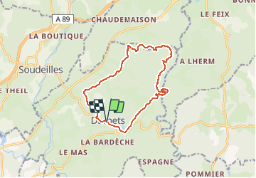
Tocht Stappen van 13,2 km beschikbaar op Nieuw-Aquitanië, Corrèze, Darnets. Deze tocht wordt voorgesteld door fanclem.
Beschrijving
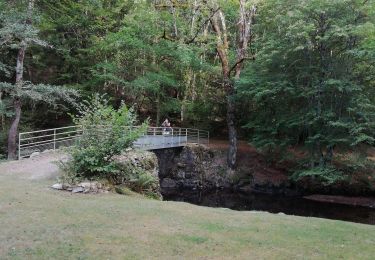
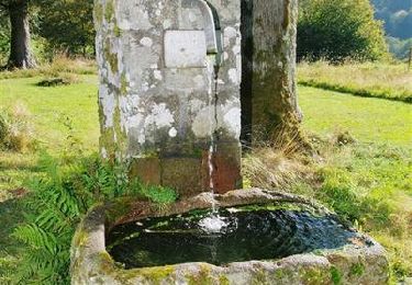
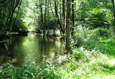
Départ de Darnets, passage au moulin du Lieuteret, la Gayée, bord de la Luzège. On remonte chez le Prince, retour par le Montusclat et les Roussilles
Plaatsbepaling
Land:
France
Regio :
Nieuw-Aquitanië
Departement/Provincie :
Corrèze
Gemeente :
Darnets
Locatie:
Unknown
Vertrek:(Dec)
Vertrek:(UTM)
430479 ; 5030753 (31T) N.
Opmerkingen
Wandeltochten in de omgeving
![Tocht Stappen Darnets - boucle des Troubadours - Photo](https://media.geolcdn.com/t/375/260/1a6934bf-a452-46e4-b656-94f59b0625b4.jpg&format=jpg&maxdim=2)
![Stappen Stappen](https://static1.geolcdn.com/sitytour/trail-icons/101.png)
boucle des Troubadours
Stappen
Medium
(2)
Darnets,
Nieuw-Aquitanië,
Corrèze,
France
![](/images/other/stat-length.png)
16 km | 21 km-effort
5h 26min
![](https://static1.geolcdn.com/siteimages/upload/files/16400158638029165_repeat_loop_refresh_sync_direction_icon.png)
Ja
![Tocht Mountainbike Égletons - le tour d'egletons - Photo](https://media.geolcdn.com/t/375/260/ext.jpg?maxdim=2&url=https%3A%2F%2Fservices.sitytrail.com%2FGeolivesWS%2FDownloadMedia.ashx%3FTrailID%3D302065%26Media%3D20140504184613.jpg)
![Mountainbike Mountainbike](https://static1.geolcdn.com/sitytour/trail-icons/202.png)
le tour d'egletons
Mountainbike
Gemakkelijk
(1)
Égletons,
Nieuw-Aquitanië,
Corrèze,
France
![](/images/other/stat-length.png)
27 km | 34 km-effort
1h 16min
![](https://static1.geolcdn.com/siteimages/upload/files/16400158638029165_repeat_loop_refresh_sync_direction_icon.png)
Ja
![Tocht Stappen Moustier-Ventadour - Découverte de Moustier Ventadour - Pays d'Egletons - Photo](https://media.geolcdn.com/t/375/260/ext.jpg?maxdim=2&url=https%3A%2F%2Fservices.sitytrail.com%2FGeolivesWS%2FDownloadMedia.ashx%3FTrailID%3D112285%26Media%3D10293_1.jpg)
![Stappen Stappen](https://static1.geolcdn.com/sitytour/trail-icons/101.png)
Découverte de Moustier Ventadour - Pays d'Egletons
Stappen
Medium
(1)
Moustier-Ventadour,
Nieuw-Aquitanië,
Corrèze,
France
![](/images/other/stat-length.png)
8,3 km | 12,2 km-effort
3h 0min
![](https://static1.geolcdn.com/siteimages/upload/files/16400158638029165_repeat_loop_refresh_sync_direction_icon.png)
Ja
![Tocht Stappen Soudeilles - Soudeillette - Photo](https://media.geolcdn.com/t/375/260/b08bb52f-45ad-4232-897a-87776904af4d.jpg&format=jpg&maxdim=2)
![Stappen Stappen](https://static1.geolcdn.com/sitytour/trail-icons/101.png)
Soudeillette
Stappen
Moeilijk
Soudeilles,
Nieuw-Aquitanië,
Corrèze,
France
![](/images/other/stat-length.png)
13,6 km | 17,3 km-effort
3h 40min
![](https://static1.geolcdn.com/siteimages/upload/files/16400158638029165_repeat_loop_refresh_sync_direction_icon.png)
Ja
![Tocht Stappen Moustier-Ventadour - Fred moutier ventadour - Photo](https://media.geolcdn.com/t/375/260/1e0a23f1-f7d2-422d-b518-af52e46c17f0.jpg&format=jpg&maxdim=2)
![Stappen Stappen](https://static1.geolcdn.com/sitytour/trail-icons/101.png)
Fred moutier ventadour
Stappen
Heel gemakkelijk
Moustier-Ventadour,
Nieuw-Aquitanië,
Corrèze,
France
![](/images/other/stat-length.png)
8,3 km | 12,3 km-effort
2h 53min
![](https://static1.geolcdn.com/siteimages/upload/files/16400158638029165_repeat_loop_refresh_sync_direction_icon.png)
Neen
![Tocht Mountainbike Moustier-Ventadour - Le chemin de la Valade - Moustier Ventadour - Pays d'Egletons - Photo](https://media.geolcdn.com/t/375/260/ext.jpg?maxdim=2&url=https%3A%2F%2Fservices.sitytrail.com%2FGeolivesWS%2FDownloadMedia.ashx%3FTrailID%3D112236%26Media%3D10150_1.jpg)
![Mountainbike Mountainbike](https://static1.geolcdn.com/sitytour/trail-icons/202.png)
Le chemin de la Valade - Moustier Ventadour - Pays d'Egletons
Mountainbike
Medium
Moustier-Ventadour,
Nieuw-Aquitanië,
Corrèze,
France
![](/images/other/stat-length.png)
6,7 km | 9,7 km-effort
40min
![](https://static1.geolcdn.com/siteimages/upload/files/16400158638029165_repeat_loop_refresh_sync_direction_icon.png)
Ja
![Tocht Stappen Moustier-Ventadour - Le chemin de la Valade - Moustier Ventadour - Pays d'Egletons - Photo](https://media.geolcdn.com/t/375/260/ext.jpg?maxdim=2&url=https%3A%2F%2Fservices.sitytrail.com%2FGeolivesWS%2FDownloadMedia.ashx%3FTrailID%3D112235%26Media%3D10150_1.jpg)
![Stappen Stappen](https://static1.geolcdn.com/sitytour/trail-icons/101.png)
Le chemin de la Valade - Moustier Ventadour - Pays d'Egletons
Stappen
Moeilijk
Moustier-Ventadour,
Nieuw-Aquitanië,
Corrèze,
France
![](/images/other/stat-length.png)
6,7 km | 9,7 km-effort
2h 30min
![](https://static1.geolcdn.com/siteimages/upload/files/16400158638029165_repeat_loop_refresh_sync_direction_icon.png)
Ja
![Tocht Stappen Darnets - La Luzège aux eaux vives - Darnets - Pays d'Egletons - Photo](https://media.geolcdn.com/t/375/260/ext.jpg?maxdim=2&url=https%3A%2F%2Fservices.sitytrail.com%2FGeolivesWS%2FDownloadMedia.ashx%3FTrailID%3D112234%26Media%3D10149_1.jpg)
![Stappen Stappen](https://static1.geolcdn.com/sitytour/trail-icons/101.png)
La Luzège aux eaux vives - Darnets - Pays d'Egletons
Stappen
Medium
(1)
Darnets,
Nieuw-Aquitanië,
Corrèze,
France
![](/images/other/stat-length.png)
4,1 km | 6,5 km-effort
1h 40min
![](https://static1.geolcdn.com/siteimages/upload/files/16400158638029165_repeat_loop_refresh_sync_direction_icon.png)
Ja
![Tocht Stappen Moustier-Ventadour - Ruisseau du Lieuteret - Photo](https://media.geolcdn.com/t/375/260/ext.jpg?maxdim=2&url=https%3A%2F%2Fstatic1.geolcdn.com%2Fsiteimages%2Fupload%2Ffiles%2F1553511878bg_sport_marche.png)
![Stappen Stappen](https://static1.geolcdn.com/sitytour/trail-icons/101.png)
Ruisseau du Lieuteret
Stappen
Moeilijk
Moustier-Ventadour,
Nieuw-Aquitanië,
Corrèze,
France
![](/images/other/stat-length.png)
13,3 km | 18,2 km-effort
4h 7min
![](https://static1.geolcdn.com/siteimages/upload/files/16400158638029165_repeat_loop_refresh_sync_direction_icon.png)
Ja