![](/images/other/stat-length.png)
![Tocht Paardrijden Lampertsloch - exp_26 Apr 2021 at 17-39-47.gpx - Photo](https://media.geolcdn.com/t/1900/400/df28235c-f954-4ccc-bfe8-f13964ef7cbf.jpg&format=pjpeg&maxdim=2)
exp_26 Apr 2021 at 17-39-47.gpx
Tourisme Equestre Alsace
Promouvoir le Tourisme Equestre en Alsace GUIDE+
![Lengte](/images/other/stat-length.png)
Lengte
34 km
![Max. hoogte](https://static1.geolcdn.com/siteimages/upload/files/1508320355ic_sort_altitude_max_24dp.png)
Max. hoogte
431 m
![Positief hoogteverschil](https://static1.geolcdn.com/siteimages/upload/files/1508320355ic_sort_den_pos_24dp.png)
Positief hoogteverschil
869 m
![Km-Effort](/images/other/stat-length.png)
Km-Effort
45 km
![Min. hoogte](https://static1.geolcdn.com/siteimages/upload/files/1508320355ic_sort_altitude_min_24dp.png)
Min. hoogte
193 m
![Negatief hoogteverschil](https://static1.geolcdn.com/siteimages/upload/files/1508320355ic_sort_den_neg_24dp.png)
Negatief hoogteverschil
841 m
![Boucle](https://static1.geolcdn.com/siteimages/upload/files/16400158638029165_repeat_loop_refresh_sync_direction_icon.png)
Boucle
Ja
Datum van aanmaak :
2021-05-04 21:11:42.332
Laatste wijziging :
2021-05-04 21:15:41.11
![Paardrijden](https://static1.geolcdn.com/sitytour/trail-icons/301.png)
5h56
Moeilijkheid : Zeer moeilijk
![Huifkarwandeling](https://static1.geolcdn.com/sitytour/trail-icons/302.png)
--
Moeilijkheid : Heel gemakkelijk
![Scan deze QR-code om de tocht te openen in de SityTrail-applicatie](https://capi.geolives.com/qq0zvz2zws4bq2lad0pu/sitytour/trails/2773738/qr.png?size=200)
Gratisgps-wandelapplicatie
Over ons
Tocht Paardrijden van 34 km beschikbaar op Grand Est, Bas-Rhin, Lampertsloch. Deze tocht wordt voorgesteld door Tourisme Equestre Alsace.
Beschrijving
Boucle au départ de Lampertsloch adaptée aux attelages en passant par Four a Chaux, le Gimbelhof et Climbach (Chapelle).
POI's
Plaatsbepaling
Land:
France
Regio :
Grand Est
Departement/Provincie :
Bas-Rhin
Gemeente :
Lampertsloch
Locatie:
Unknown
Vertrek:(Dec)
Vertrek:(UTM)
412830 ; 5424143 (32U) N.
Opmerkingen
Wandeltochten in de omgeving
![Tocht Mountainbike Cleebourg - Petite sortie VTT sympa secteur Wissembourg - Photo](https://media.geolcdn.com/t/375/260/ext.jpg?maxdim=2&url=https%3A%2F%2Fservices.sitytrail.com%2FGeolivesWS%2FDownloadMedia.ashx%3FTrailID%3D172562%26Media%3D13931_1.jpg)
![Mountainbike Mountainbike](https://static1.geolcdn.com/sitytour/trail-icons/202.png)
Petite sortie VTT sympa secteur Wissembourg
Mountainbike
Medium
(1)
Cleebourg,
Grand Est,
Bas-Rhin,
France
![](/images/other/stat-length.png)
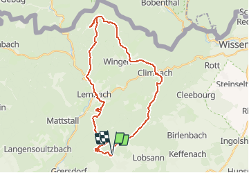
23 km | 32 km-effort
2h 30min
![](https://static1.geolcdn.com/siteimages/upload/files/16400158638029165_repeat_loop_refresh_sync_direction_icon.png)
Ja
![Tocht Paardrijden Lampertsloch - suuntoapp-HorsebackRiding-2024-10-02T07-31-37Z - Photo](https://media.geolcdn.com/t/375/260/c4aea363-eee4-4f2c-aa47-cc0f084521d0.jpg&format=jpg&maxdim=2)
![Paardrijden Paardrijden](https://static1.geolcdn.com/sitytour/trail-icons/301.png)
suuntoapp-HorsebackRiding-2024-10-02T07-31-37Z
Paardrijden
Moeilijk
Lampertsloch,
Grand Est,
Bas-Rhin,
France
![](/images/other/stat-length.png)
26 km | 32 km-effort
4h 12min
![](https://static1.geolcdn.com/siteimages/upload/files/16400158638029165_repeat_loop_refresh_sync_direction_icon.png)
Neen
![Tocht Paardrijden Lembach - suuntoapp-HorsebackRiding-2024-09-28T07-36-13Z - Photo](https://media.geolcdn.com/t/375/260/367565ab-a270-4d2f-b447-b233ac7ee2cd.jpg&format=jpg&maxdim=2)
![Paardrijden Paardrijden](https://static1.geolcdn.com/sitytour/trail-icons/301.png)
suuntoapp-HorsebackRiding-2024-09-28T07-36-13Z
Paardrijden
Moeilijk
Lembach,
Grand Est,
Bas-Rhin,
France
![](/images/other/stat-length.png)
28 km | 40 km-effort
5h 15min
![](https://static1.geolcdn.com/siteimages/upload/files/16400158638029165_repeat_loop_refresh_sync_direction_icon.png)
Neen
![Tocht Paardrijden Lembach - suuntoapp-HorsebackRiding-2024-09-27T08-57-29Z - Photo](https://media.geolcdn.com/t/375/260/c03dafc3-2f7c-44ee-996b-e27cd7572a07.jpg&format=jpg&maxdim=2)
![Paardrijden Paardrijden](https://static1.geolcdn.com/sitytour/trail-icons/301.png)
suuntoapp-HorsebackRiding-2024-09-27T08-57-29Z
Paardrijden
Medium
Lembach,
Grand Est,
Bas-Rhin,
France
![](/images/other/stat-length.png)
19,1 km | 27 km-effort
3h 31min
![](https://static1.geolcdn.com/siteimages/upload/files/16400158638029165_repeat_loop_refresh_sync_direction_icon.png)
Ja
![Tocht Te voet Lembach - Anneau vert - Photo](https://media.geolcdn.com/t/375/260/94c60cdc-936e-47ee-9965-23e9ec9e034a.jpeg&format=jpg&maxdim=2)
![Te voet Te voet](https://static1.geolcdn.com/sitytour/trail-icons/100.png)
Anneau vert
Te voet
Gemakkelijk
Lembach,
Grand Est,
Bas-Rhin,
France
![](/images/other/stat-length.png)
3,8 km | 5,2 km-effort
1h 10min
![](https://static1.geolcdn.com/siteimages/upload/files/16400158638029165_repeat_loop_refresh_sync_direction_icon.png)
Ja
![Tocht Te voet Climbach - Triangle vert - Photo](https://media.geolcdn.com/t/375/260/d3987fbc-fe59-46c7-ae84-0b08ad83df79.jpeg&format=jpg&maxdim=2)
![Te voet Te voet](https://static1.geolcdn.com/sitytour/trail-icons/100.png)
Triangle vert
Te voet
Gemakkelijk
Climbach,
Grand Est,
Bas-Rhin,
France
![](/images/other/stat-length.png)
10,3 km | 15 km-effort
3h 24min
![](https://static1.geolcdn.com/siteimages/upload/files/16400158638029165_repeat_loop_refresh_sync_direction_icon.png)
Neen
![Tocht Te voet Cleebourg - Disque jaune - Photo](https://media.geolcdn.com/t/375/260/e4476995-5782-472a-90f8-979658e5121c.jpeg&format=jpg&maxdim=2)
![Te voet Te voet](https://static1.geolcdn.com/sitytour/trail-icons/100.png)
Disque jaune
Te voet
Medium
Cleebourg,
Grand Est,
Bas-Rhin,
France
![](/images/other/stat-length.png)
20 km | 27 km-effort
6h 13min
![](https://static1.geolcdn.com/siteimages/upload/files/16400158638029165_repeat_loop_refresh_sync_direction_icon.png)
Neen
![Tocht Te voet Merkwiller-Pechelbronn - Croix bleue - Photo](https://media.geolcdn.com/t/375/260/e4476995-5782-472a-90f8-979658e5121c.jpeg&format=jpg&maxdim=2)
![Te voet Te voet](https://static1.geolcdn.com/sitytour/trail-icons/100.png)
Croix bleue
Te voet
Gemakkelijk
Merkwiller-Pechelbronn,
Grand Est,
Bas-Rhin,
France
![](/images/other/stat-length.png)
9 km | 11,9 km-effort
2h 42min
![](https://static1.geolcdn.com/siteimages/upload/files/16400158638029165_repeat_loop_refresh_sync_direction_icon.png)
Neen
![Tocht Te voet Soultz-sous-Forêts - Triangle bleu - Photo](https://media.geolcdn.com/t/375/260/a25ae779-16d3-4928-9bb3-f3032cae91fb.jpeg&format=jpg&maxdim=2)
![Te voet Te voet](https://static1.geolcdn.com/sitytour/trail-icons/100.png)
Triangle bleu
Te voet
Gemakkelijk
Soultz-sous-Forêts,
Grand Est,
Bas-Rhin,
France
![](/images/other/stat-length.png)
6,1 km | 7,2 km-effort
1h 38min
![](https://static1.geolcdn.com/siteimages/upload/files/16400158638029165_repeat_loop_refresh_sync_direction_icon.png)
Neen