Tocht Mountainbike Sankt Vith - Best E-bike Adventure

Best E-bike Adventure "le bec de corbeau"

 bikathlon
bikathlon

Gebruiker

© OpenStreetMap contributors
Lengte
Lengte
47 km
Max. hoogte
Max. hoogte
598 m
Positief hoogteverschil
856 m
Km-Effort
Km-Effort  
59 km
Min. hoogte
Min. hoogte
409 m
Negatief hoogteverschil
866 m
Boucle
Boucle
Neen
Datum van aanmaak :
2021-05-01 12:42:21.975
Laatste wijziging :
2021-05-01 18:12:08.718

(0 Bericht)

Mountainbike
Mountainbike
2h50
Moeilijkheid : Medium

Scan deze QR-code om de tocht te openen in de SityTrail-applicatie

Gratisgps-wandelapplicatie

Logo SityTrail SityTrail

IGN / Geografische instituten

SityTrail uit de App Store downloaden SityTrail uit Google Play downloaden

Logo SityTrail SityTrail World

De wereld gaat voor u open

SityTrail uit de App Store downloaden SityTrail uit Google Play downloaden SityTrail op Huawei AppGallery downloaden

Over ons

Tocht Mountainbike van 47 km beschikbaar op Wallonië, Luik, Sankt Vith. Deze tocht wordt voorgesteld door bikathlon.

Beschrijving

randonnée moutain bike Recht Viesalm Commanster et retour par ke chemin des bornes

Hoogteprofiel

Plaatsbepaling

Land:
Belgium
Regio :
Wallonië
Departement/Provincie :
Luik
Gemeente :
Sankt Vith
Locatie:
Recht
Vertrek:(UTM)
288056 ; 5578941 (32U) N.

Wandeltochten in de omgeving

Tocht Stappen Trois-Ponts - Logbiermé. Natura 2000, des sites qui valent le détour ! Lg5 - Photo
Stappen
GUIDE+

Stappen

Gemakkelijk
(10)
Trois-Ponts, Wallonië, Luik, Belgium
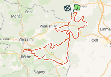
8,4 km | 10,9 km-effort
Onbekend
Ja
Tocht Stappen Sankt Vith - 2021-05-17_18h38m48_recht - Photo
Stappen
GUIDE
mumu.larandonneuse

Stappen

Gemakkelijk
(1)
Sankt Vith, Wallonië, Luik, Belgium
13,3 km | 17,8 km-effort
4h 2min
Ja
Tocht Stappen Sankt Vith - Rodt - Chiens de traineau  - Photo
Stappen
GUIDE
mumu.larandonneuse

Stappen

Medium
Sankt Vith, Wallonië, Luik, Belgium
8,4 km | 10,6 km-effort
1h 52min
Ja
Tocht Stappen Sankt Vith - 20220904 - Rodt 4.7 Km - Photo
Stappen
GUIDE
pierreh01

Stappen

Gemakkelijk
Sankt Vith, Wallonië, Luik, Belgium
4,7 km | 5,9 km-effort
1h 20min
Ja
Tocht Te voet Trois-Ponts - 13. Promenade des Bruyères - Photo
Te voet
PRO

Te voet

Gemakkelijk
Trois-Ponts, Wallonië, Luik, Belgium
9,2 km | 12,1 km-effort
2h 44min
Ja
Tocht Te voet Trois-Ponts - 12. Promenade des Bornes Frontières - Photo
Te voet
PRO

Te voet

Gemakkelijk
Trois-Ponts, Wallonië, Luik, Belgium
8,4 km | 11 km-effort
2h 30min
Ja
Tocht Te voet Trois-Ponts - Liaison - Photo
Te voet
PRO

Te voet

Gemakkelijk
Trois-Ponts, Wallonië, Luik, Belgium
3,1 km | 4,1 km-effort
55min
Neen
Tocht Stappen Sankt Vith - Recht 22 km - Photo
Stappen
GUIDE
rvapeldo

Stappen

Gemakkelijk
Sankt Vith, Wallonië, Luik, Belgium
22 km | 29 km-effort
5h 37min
Ja
Tocht Stappen Stavelot - Refat 17,3km - Photo
Stappen
wandelgidszuidlimburg

Stappen

Heel gemakkelijk
(1)
Stavelot, Wallonië, Luik, Belgium
17,2 km | 24 km-effort
Onbekend
Ja


Sluiten
Mijn abonnementen