![](/images/other/stat-length.png)
![Tocht Stappen Bedous - BEDOUS-ACCOUS par le Borde de Couy-Petrou - G3 - Photo](https://media.geolcdn.com/t/1900/400/ext.pjpeg?maxdim=2&url=https%3A%2F%2Fstatic1.geolcdn.com%2Fsiteimages%2Fupload%2Ffiles%2F1553511878bg_sport_marche.png)
BEDOUS-ACCOUS par le Borde de Couy-Petrou - G3
mitch1952
Gebruiker
![Lengte](/images/other/stat-length.png)
Lengte
12,7 km
![Max. hoogte](https://static1.geolcdn.com/siteimages/upload/files/1508320355ic_sort_altitude_max_24dp.png)
Max. hoogte
843 m
![Positief hoogteverschil](https://static1.geolcdn.com/siteimages/upload/files/1508320355ic_sort_den_pos_24dp.png)
Positief hoogteverschil
534 m
![Km-Effort](/images/other/stat-length.png)
Km-Effort
19,8 km
![Min. hoogte](https://static1.geolcdn.com/siteimages/upload/files/1508320355ic_sort_altitude_min_24dp.png)
Min. hoogte
416 m
![Negatief hoogteverschil](https://static1.geolcdn.com/siteimages/upload/files/1508320355ic_sort_den_neg_24dp.png)
Negatief hoogteverschil
534 m
![Boucle](https://static1.geolcdn.com/siteimages/upload/files/16400158638029165_repeat_loop_refresh_sync_direction_icon.png)
Boucle
Ja
Datum van aanmaak :
2021-04-30 08:11:43.78
Laatste wijziging :
2022-06-08 13:25:34.656
![Stappen](https://static1.geolcdn.com/sitytour/trail-icons/101.png)
5h00
Moeilijkheid : Medium
![Scan deze QR-code om de tocht te openen in de SityTrail-applicatie](https://capi.geolives.com/qq0zvz2zws4bq2lad0pu/sitytour/trails/2767387/qr.png?size=200)
Gratisgps-wandelapplicatie
Over ons
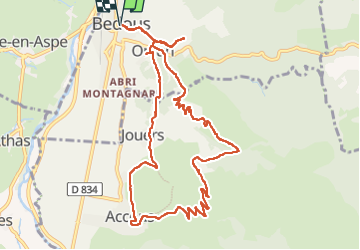
Tocht Stappen van 12,7 km beschikbaar op Nieuw-Aquitanië, Pyrénées-Atlantiques, Bedous. Deze tocht wordt voorgesteld door mitch1952.
Beschrijving
Beau G3 permettant de jolis panoramas sur la vallée d’Aspe, ses villages (Lees, Athas, Osse en Aspe) et les sommets autour. Pas de difficultés particulières.
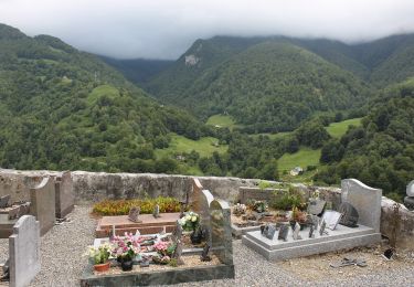
Visite du rocher qui pleure à Bedous à 300m de la boulangerie
Parking sur la place de l'Eglise.
Plaatsbepaling
Land:
France
Regio :
Nieuw-Aquitanië
Departement/Provincie :
Pyrénées-Atlantiques
Gemeente :
Bedous
Locatie:
Unknown
Vertrek:(Dec)
Vertrek:(UTM)
695606 ; 4763494 (30T) N.
Opmerkingen
Wandeltochten in de omgeving
![Tocht Stappen Accous - ACCOUS Chapelle San Christau](https://media.geolcdn.com/t/375/260/40c2b7e8-ffbe-4c46-b83e-62c3011b6688.jpg&format=jpg&maxdim=2)
![Stappen Stappen](https://static1.geolcdn.com/sitytour/trail-icons/101.png)
ACCOUS Chapelle San Christau "2805437"
Stappen
Gemakkelijk
(1)
Accous,
Nieuw-Aquitanië,
Pyrénées-Atlantiques,
France
![](/images/other/stat-length.png)
8,8 km | 14,3 km-effort
2h 44min
![](https://static1.geolcdn.com/siteimages/upload/files/16400158638029165_repeat_loop_refresh_sync_direction_icon.png)
Ja
![Tocht Stappen Bedous - Le Tour de Saudious - Photo](https://media.geolcdn.com/t/375/260/ext.jpg?maxdim=2&url=https%3A%2F%2Fservices.sitytrail.com%2FGeolivesWS%2FDownloadMedia.ashx%3FTrailID%3D110248%26Media%3D5551_6.jpg)
![Stappen Stappen](https://static1.geolcdn.com/sitytour/trail-icons/101.png)
Le Tour de Saudious
Stappen
Medium
(1)
Bedous,
Nieuw-Aquitanië,
Pyrénées-Atlantiques,
France
![](/images/other/stat-length.png)
6 km | 8,7 km-effort
1h 30min
![](https://static1.geolcdn.com/siteimages/upload/files/16400158638029165_repeat_loop_refresh_sync_direction_icon.png)
Ja
![Tocht Stappen Bedous - BEDOUS le tour du Pouey autrement](https://media.geolcdn.com/t/375/260/03231525-2563-4126-84d1-fc81f72a3b22.jpg&format=jpg&maxdim=2)
![Stappen Stappen](https://static1.geolcdn.com/sitytour/trail-icons/101.png)
BEDOUS le tour du Pouey autrement "4119701"
Stappen
Moeilijk
Bedous,
Nieuw-Aquitanië,
Pyrénées-Atlantiques,
France
![](/images/other/stat-length.png)
9 km | 13,4 km-effort
3h 2min
![](https://static1.geolcdn.com/siteimages/upload/files/16400158638029165_repeat_loop_refresh_sync_direction_icon.png)
Ja
![Tocht Te voet Bedous - BEDOUS les chemins du gaves G4](https://media.geolcdn.com/t/375/260/9e91315c-b4be-4963-9ba8-48016c7d9f89.jpg&format=jpg&maxdim=2)
![Te voet Te voet](https://static1.geolcdn.com/sitytour/trail-icons/100.png)
BEDOUS les chemins du gaves G4 "4014081"
Te voet
Gemakkelijk
Bedous,
Nieuw-Aquitanië,
Pyrénées-Atlantiques,
France
![](/images/other/stat-length.png)
11,2 km | 12,9 km-effort
2h 55min
![](https://static1.geolcdn.com/siteimages/upload/files/16400158638029165_repeat_loop_refresh_sync_direction_icon.png)
Ja
![Te voet Te voet](https://static1.geolcdn.com/sitytour/trail-icons/100.png)
BEDOUS Le tour du Bugala par Osse en Aspe
Te voet
Gemakkelijk
Bedous,
Nieuw-Aquitanië,
Pyrénées-Atlantiques,
France
![](/images/other/stat-length.png)
11,6 km | 16,8 km-effort
3h 56min
![](https://static1.geolcdn.com/siteimages/upload/files/16400158638029165_repeat_loop_refresh_sync_direction_icon.png)
Ja
![Tocht Te voet Accous - Sommet du Poey asp122 - Photo](https://media.geolcdn.com/t/375/260/2d07cf2c-8954-4ab2-916e-821bbcb77891.jpeg&format=jpg&maxdim=2)
![Te voet Te voet](https://static1.geolcdn.com/sitytour/trail-icons/100.png)
Sommet du Poey asp122
Te voet
Gemakkelijk
Accous,
Nieuw-Aquitanië,
Pyrénées-Atlantiques,
France
![](/images/other/stat-length.png)
3,5 km | 5,7 km-effort
1h 17min
![](https://static1.geolcdn.com/siteimages/upload/files/16400158638029165_repeat_loop_refresh_sync_direction_icon.png)
Ja
![Tocht Te voet Osse-en-Aspe - Tour panoramique Osse-Athas asp109 - Photo](https://media.geolcdn.com/t/375/260/fd742eea-9420-4aa3-9b7d-11c6f4a57c86.jpeg&format=jpg&maxdim=2)
![Te voet Te voet](https://static1.geolcdn.com/sitytour/trail-icons/100.png)
Tour panoramique Osse-Athas asp109
Te voet
Gemakkelijk
Osse-en-Aspe,
Nieuw-Aquitanië,
Pyrénées-Atlantiques,
France
![](/images/other/stat-length.png)
8,3 km | 12,1 km-effort
2h 44min
![](https://static1.geolcdn.com/siteimages/upload/files/16400158638029165_repeat_loop_refresh_sync_direction_icon.png)
Neen
![Tocht Te voet Aydius - Tour du Mailh Massibé par Bésur asp100 - Photo](https://media.geolcdn.com/t/375/260/63a6bafa-5459-4dce-bf36-a3e4ba983890.jpeg&format=jpg&maxdim=2)
![Te voet Te voet](https://static1.geolcdn.com/sitytour/trail-icons/100.png)
Tour du Mailh Massibé par Bésur asp100
Te voet
Medium
Aydius,
Nieuw-Aquitanië,
Pyrénées-Atlantiques,
France
![](/images/other/stat-length.png)
9,8 km | 23 km-effort
5h 7min
![](https://static1.geolcdn.com/siteimages/upload/files/16400158638029165_repeat_loop_refresh_sync_direction_icon.png)
Neen
![Tocht Te voet Aydius - Chemin des Buis de Camploung asp22 - Photo](https://media.geolcdn.com/t/375/260/63a6bafa-5459-4dce-bf36-a3e4ba983890.jpeg&format=jpg&maxdim=2)
![Te voet Te voet](https://static1.geolcdn.com/sitytour/trail-icons/100.png)
Chemin des Buis de Camploung asp22
Te voet
Gemakkelijk
Aydius,
Nieuw-Aquitanië,
Pyrénées-Atlantiques,
France
![](/images/other/stat-length.png)
4,1 km | 6,3 km-effort
1h 26min
![](https://static1.geolcdn.com/siteimages/upload/files/16400158638029165_repeat_loop_refresh_sync_direction_icon.png)
Ja