![](/images/other/stat-length.png)
![Tocht Stappen Fournet-Blancheroche - Fournet Blancheroche Le Refrain (IBP87) 22 avril 2021 CAF - Photo](https://media.geolcdn.com/t/1900/400/c01e38d9-a694-41fc-adc2-319ae93eb4b6.jpg&format=pjpeg&maxdim=2)
Fournet Blancheroche Le Refrain (IBP87) 22 avril 2021 CAF
TRIMAILLE
Gebruiker
![Lengte](/images/other/stat-length.png)
Lengte
22 km
![Max. hoogte](https://static1.geolcdn.com/siteimages/upload/files/1508320355ic_sort_altitude_max_24dp.png)
Max. hoogte
1021 m
![Positief hoogteverschil](https://static1.geolcdn.com/siteimages/upload/files/1508320355ic_sort_den_pos_24dp.png)
Positief hoogteverschil
893 m
![Km-Effort](/images/other/stat-length.png)
Km-Effort
34 km
![Min. hoogte](https://static1.geolcdn.com/siteimages/upload/files/1508320355ic_sort_altitude_min_24dp.png)
Min. hoogte
608 m
![Negatief hoogteverschil](https://static1.geolcdn.com/siteimages/upload/files/1508320355ic_sort_den_neg_24dp.png)
Negatief hoogteverschil
891 m
![Boucle](https://static1.geolcdn.com/siteimages/upload/files/16400158638029165_repeat_loop_refresh_sync_direction_icon.png)
Boucle
Ja
Datum van aanmaak :
2021-04-22 16:31:42.344
Laatste wijziging :
2021-04-27 13:47:38.268
![Stappen](https://static1.geolcdn.com/sitytour/trail-icons/101.png)
6h20
Moeilijkheid : Moeilijk
![Scan deze QR-code om de tocht te openen in de SityTrail-applicatie](https://capi.geolives.com/qq0zvz2zws4bq2lad0pu/sitytour/trails/2757832/qr.png?size=200)
Gratisgps-wandelapplicatie
Over ons
Tocht Stappen van 22 km beschikbaar op Bourgondië-Franche-Comté, Doubs, Fournet-Blancheroche. Deze tocht wordt voorgesteld door TRIMAILLE.
Beschrijving
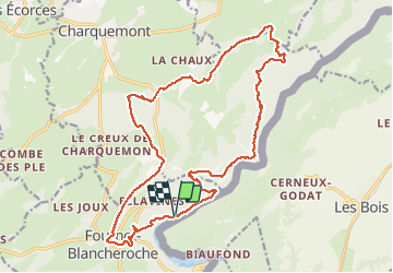
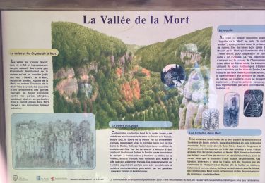
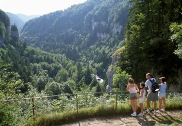
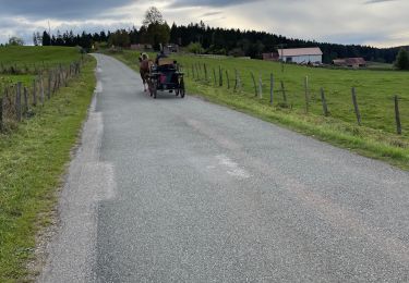
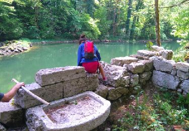
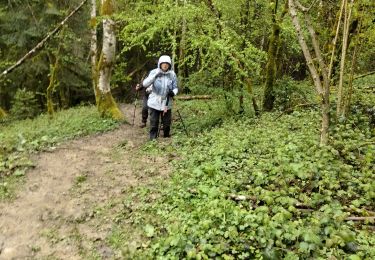
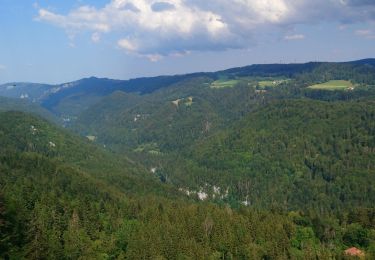
Départ du parking du barrage du Refrain. Agréable randonnée mais exigeante. Parcours variés, belvédères, crêtes, gorges du Doubs....
Plaatsbepaling
Land:
France
Regio :
Bourgondië-Franche-Comté
Departement/Provincie :
Doubs
Gemeente :
Fournet-Blancheroche
Locatie:
Unknown
Vertrek:(Dec)
Vertrek:(UTM)
336790 ; 5226768 (32T) N.
Opmerkingen
Wandeltochten in de omgeving
![Tocht Stappen Charquemont - Échelles de la mort - Photo](https://media.geolcdn.com/t/375/260/7b9848bb-a43e-4c47-8544-5e7b63b496f6.jpg&format=jpg&maxdim=2)
![Stappen Stappen](https://static1.geolcdn.com/sitytour/trail-icons/101.png)
Échelles de la mort
Stappen
Medium
(1)
Charquemont,
Bourgondië-Franche-Comté,
Doubs,
France
![](/images/other/stat-length.png)
6,5 km | 9,5 km-effort
1h 33min
![](https://static1.geolcdn.com/siteimages/upload/files/16400158638029165_repeat_loop_refresh_sync_direction_icon.png)
Ja
![Tocht Stappen Charquemont - Les Echelles de la Mort - Doubs - Photo](https://media.geolcdn.com/t/375/260/ext.jpg?maxdim=2&url=https%3A%2F%2Fservices.sitytrail.com%2FGeolivesWS%2FDownloadMedia.ashx%3FTrailID%3D108929%26Media%3D2620_1.jpg)
![Stappen Stappen](https://static1.geolcdn.com/sitytour/trail-icons/101.png)
Les Echelles de la Mort - Doubs
Stappen
Medium
(2)
Charquemont,
Bourgondië-Franche-Comté,
Doubs,
France
![](/images/other/stat-length.png)
8,4 km | 14,1 km-effort
3h 0min
![](https://static1.geolcdn.com/siteimages/upload/files/16400158638029165_repeat_loop_refresh_sync_direction_icon.png)
Ja
![Tocht Stappen Fournet-Blancheroche - Combe de Biaufond - Photo](https://media.geolcdn.com/t/375/260/ext.jpg?maxdim=2&url=https%3A%2F%2Fstatic1.geolcdn.com%2Fsiteimages%2Fupload%2Ffiles%2F1553511878bg_sport_marche.png)
![Stappen Stappen](https://static1.geolcdn.com/sitytour/trail-icons/101.png)
Combe de Biaufond
Stappen
Medium
(1)
Fournet-Blancheroche,
Bourgondië-Franche-Comté,
Doubs,
France
![](/images/other/stat-length.png)
11,7 km | 18,3 km-effort
4h 17min
![](https://static1.geolcdn.com/siteimages/upload/files/16400158638029165_repeat_loop_refresh_sync_direction_icon.png)
Neen
![Tocht sport Charquemont - Charquemont - Photo](https://media.geolcdn.com/t/375/260/2f6ea34c-c41e-4747-afa9-f8bc25b75ed3.jpg&format=jpg&maxdim=2)
Charquemont
sport
Heel gemakkelijk
Charquemont,
Bourgondië-Franche-Comté,
Doubs,
France
![](/images/other/stat-length.png)
5,5 km | 7,9 km-effort
Onbekend
![](https://static1.geolcdn.com/siteimages/upload/files/16400158638029165_repeat_loop_refresh_sync_direction_icon.png)
Ja
![Tocht Stappen Charquemont - gorges du Doubs - Photo](https://media.geolcdn.com/t/375/260/ext.jpg?maxdim=2&url=https%3A%2F%2Fservices.sitytrail.com%2FGeolivesWS%2FDownloadMedia.ashx%3FTrailID%3D759641%26Media%3Dfix__20170525134753.jpg)
![Stappen Stappen](https://static1.geolcdn.com/sitytour/trail-icons/101.png)
gorges du Doubs
Stappen
Medium
Charquemont,
Bourgondië-Franche-Comté,
Doubs,
France
![](/images/other/stat-length.png)
12,2 km | 19,6 km-effort
3h 36min
![](https://static1.geolcdn.com/siteimages/upload/files/16400158638029165_repeat_loop_refresh_sync_direction_icon.png)
Neen
![Tocht Stappen Charquemont - lçendre cha4quemond - Photo](https://media.geolcdn.com/t/375/260/d4b171d3-4707-4b81-9ad5-a84cf10f6378.jpg&format=jpg&maxdim=2)
![Stappen Stappen](https://static1.geolcdn.com/sitytour/trail-icons/101.png)
lçendre cha4quemond
Stappen
Zeer moeilijk
Charquemont,
Bourgondië-Franche-Comté,
Doubs,
France
![](/images/other/stat-length.png)
13,2 km | 22 km-effort
5h 55min
![](https://static1.geolcdn.com/siteimages/upload/files/16400158638029165_repeat_loop_refresh_sync_direction_icon.png)
Ja
![Tocht Stappen Charquemont - Combes Saint Pierre - Photo](https://media.geolcdn.com/t/375/260/0b54ab85-de60-4572-870a-d1ef0de23798.jpg&format=jpg&maxdim=2)
![Stappen Stappen](https://static1.geolcdn.com/sitytour/trail-icons/101.png)
Combes Saint Pierre
Stappen
Gemakkelijk
(1)
Charquemont,
Bourgondië-Franche-Comté,
Doubs,
France
![](/images/other/stat-length.png)
5,9 km | 8 km-effort
3h 29min
![](https://static1.geolcdn.com/siteimages/upload/files/16400158638029165_repeat_loop_refresh_sync_direction_icon.png)
Ja
![Tocht Stappen Charquemont - Goumois-Le Boulois / Les échelles de la mort - Photo](https://media.geolcdn.com/t/375/260/e486823a-bed9-43a4-abeb-bf237649de07.jpg&format=jpg&maxdim=2)
![Stappen Stappen](https://static1.geolcdn.com/sitytour/trail-icons/101.png)
Goumois-Le Boulois / Les échelles de la mort
Stappen
Medium
Charquemont,
Bourgondië-Franche-Comté,
Doubs,
France
![](/images/other/stat-length.png)
15,9 km | 26 km-effort
3h 14min
![](https://static1.geolcdn.com/siteimages/upload/files/16400158638029165_repeat_loop_refresh_sync_direction_icon.png)
Ja
![Tocht Stappen Charquemont - LES ECHELLES DE LA MORT - Photo](https://media.geolcdn.com/t/375/260/eedace1f-3156-432d-a68f-d4e4629d6189.jpg&format=jpg&maxdim=2)
![Stappen Stappen](https://static1.geolcdn.com/sitytour/trail-icons/101.png)
LES ECHELLES DE LA MORT
Stappen
Moeilijk
Charquemont,
Bourgondië-Franche-Comté,
Doubs,
France
![](/images/other/stat-length.png)
10,4 km | 17,1 km-effort
4h 42min
![](https://static1.geolcdn.com/siteimages/upload/files/16400158638029165_repeat_loop_refresh_sync_direction_icon.png)
Ja