Tocht Stappen Pont-d'Ouilly - Suisse_Normande_#J3_Pont_d'Ouilly_-_Clécy - Photo

Suisse_Normande_#J3_Pont_d'Ouilly_-_Clécy

 BureauChris
BureauChris

Gebruiker

© OpenStreetMap contributors
Lengte
Lengte
19,4 km
Max. hoogte
Max. hoogte
220 m
Positief hoogteverschil
585 m
Km-Effort
Km-Effort  
27 km
Min. hoogte
Min. hoogte
32 m
Negatief hoogteverschil
597 m
Boucle
Boucle
Neen
Datum van aanmaak :
2021-04-22 05:43:39.301
Laatste wijziging :
2021-06-23 19:45:32.737

(0 Bericht)

Stappen
Stappen
6h11
Moeilijkheid : Zeer moeilijk

Scan deze QR-code om de tocht te openen in de SityTrail-applicatie

Gratisgps-wandelapplicatie

Logo SityTrail SityTrail

IGN / Geografische instituten

SityTrail uit de App Store downloaden SityTrail uit Google Play downloaden

Logo SityTrail SityTrail World

De wereld gaat voor u open

SityTrail uit de App Store downloaden SityTrail uit Google Play downloaden SityTrail op Huawei AppGallery downloaden

Over ons

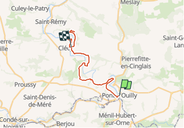
Tocht Stappen van 19,4 km beschikbaar op Normandië, Calvados, Pont-d'Ouilly. Deze tocht wordt voorgesteld door BureauChris.

Hoogteprofiel

Foto's

Plaatsbepaling

Land:
France
Regio :
Normandië
Departement/Provincie :
Calvados
Gemeente :
Pont-d'Ouilly
Locatie:
Unknown
Vertrek:(Dec)
Vertrek:(UTM)
689929 ; 5416667 (30U) N.

Wandeltochten in de omgeving

Tocht Mountainbike Pont-d'Ouilly - La Petite Suisse Normande 2014 - Pont-d'Ouilly - Photo
Mountainbike
tracegps

Mountainbike

Moeilijk
(1)
Pont-d'Ouilly, Normandië, Calvados, France
41 km | 54 km-effort
3h 30min
Ja
Tocht Stappen Saint-Philbert-sur-Orne - Autour des roches d'oetre - Photo
Stappen
phi14

Stappen

Gemakkelijk
(3)
Saint-Philbert-sur-Orne, Normandië, Orne, France
9,7 km | 12,4 km-effort
2h 30min
Ja
Tocht Stappen Saint-Philbert-sur-Orne - Roche d’oëtre sentier du Granite - Photo
Stappen
zefreefly

Stappen

Heel gemakkelijk
Saint-Philbert-sur-Orne, Normandië, Orne, France
10,1 km | 12,7 km-effort
2h 43min
Ja
Tocht Stappen Le Vey - Clécy - Photo
Stappen
zefreefly

Stappen

Gemakkelijk
(1)
Le Vey, Normandië, Calvados, France
14,8 km | 20 km-effort
3h 51min
Ja
Tocht Stappen Saint-Philbert-sur-Orne - Circuit des méandres  - Photo
Stappen
JLPIERSON

Stappen

Medium
Saint-Philbert-sur-Orne, Normandië, Orne, France
6,4 km | 8,4 km-effort
1h 54min
Ja
Tocht Stappen Ménil-Hubert-sur-Orne - De Rouvroy aux Roches d'Oetre par le sentier des Méandres  - Photo
Stappen
Ecureuiltrailer

Stappen

Medium
Ménil-Hubert-sur-Orne, Normandië, Orne, France
7,1 km | 9,3 km-effort
2h 1min
Ja
Tocht Te voet Saint-Philbert-sur-Orne - Entre Orne et Rouvre - Photo
Te voet
PRO

Te voet

Gemakkelijk
Saint-Philbert-sur-Orne, Normandië, Orne, France
7,7 km | 10,3 km-effort
2h 19min
Ja
Tocht Te voet Pont-d'Ouilly - Circuit du Val la Hère - Photo
Te voet
PRO

Te voet

Gemakkelijk
Pont-d'Ouilly, Normandië, Calvados, France
6,7 km | 9,4 km-effort
2h 7min
Ja
Tocht Te voet Le Bô - Des Montagnes de Normandie? - Photo
Te voet
PRO

Te voet

Medium
Le Bô, Normandië, Calvados, France
15,4 km | 20 km-effort
4h 38min
Neen


Sluiten
Mijn abonnementen