![](/images/other/stat-length.png)
![Tocht Stappen Chauvé - Circuit des Marais et des Moulins - Photo](https://media.geolcdn.com/t/1900/400/ext.pjpeg?maxdim=2&url=https%3A%2F%2Fstatic1.geolcdn.com%2Fsiteimages%2Fupload%2Ffiles%2F1553511878bg_sport_marche.png)
Circuit des Marais et des Moulins
LeonEvain
Gebruiker
![Lengte](/images/other/stat-length.png)
![Max. hoogte](https://static1.geolcdn.com/siteimages/upload/files/1508320355ic_sort_altitude_max_24dp.png)
![Positief hoogteverschil](https://static1.geolcdn.com/siteimages/upload/files/1508320355ic_sort_den_pos_24dp.png)
![Km-Effort](/images/other/stat-length.png)
![Min. hoogte](https://static1.geolcdn.com/siteimages/upload/files/1508320355ic_sort_altitude_min_24dp.png)
![Negatief hoogteverschil](https://static1.geolcdn.com/siteimages/upload/files/1508320355ic_sort_den_neg_24dp.png)
![Boucle](https://static1.geolcdn.com/siteimages/upload/files/16400158638029165_repeat_loop_refresh_sync_direction_icon.png)
![Stappen](https://static1.geolcdn.com/sitytour/trail-icons/101.png)
3h33
Moeilijkheid : Moeilijk
![Scan deze QR-code om de tocht te openen in de SityTrail-applicatie](https://capi.geolives.com/qq0zvz2zws4bq2lad0pu/sitytour/trails/2754861/qr.png?size=200)
Gratisgps-wandelapplicatie
Over ons
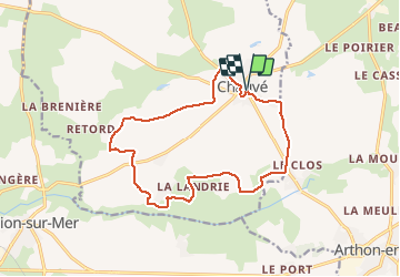
Tocht Stappen van 14,6 km beschikbaar op Pays de la Loire, Loire-Atlantique, Chauvé. Deze tocht wordt voorgesteld door LeonEvain.
Beschrijving
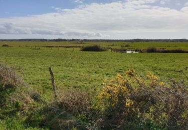
Bienvenue à Chauvé sur le circuit "Marais et moulins" : une randonnée au coeur d'un milieu naturel empreint d'histoire.
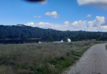
Tandis que les marais attenants au canal de Haute-Perche vous offrent la possibilité d’observer une faune et une flore diversifiées, le canal lui-même se fait écho du transport des marchandises de l’arrière-pays vers la côte : briques, tuiles et céréales…
À voir en chemin :
Les ruines du Moulin de Haute-Perche
Le Manoir de la Rigaudière et son moulin du 15ème siècle
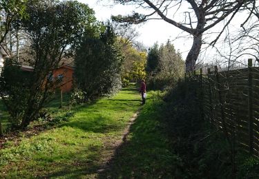
La faune et la flore des marais
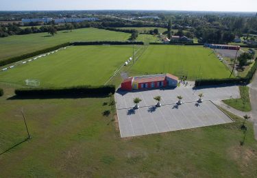
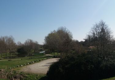
Départ : Parc de loisirs
Durée : temps estimé par défaut à pied. Le circuit est également accessible à vélo (1h45mn) et à cheval (2h20).
Plaatsbepaling
Opmerkingen
Wandeltochten in de omgeving
![Tocht Te voet Chaumes-en-Retz - Sentier pédestre des Iles Enchantées - Photo](https://media.geolcdn.com/t/375/260/8d9b3652-bedc-4903-8d23-e450b9c65d96.jpeg&format=jpg&maxdim=2)
![Te voet Te voet](https://static1.geolcdn.com/sitytour/trail-icons/100.png)
Te voet
![](/images/other/stat-length.png)
![](https://static1.geolcdn.com/siteimages/upload/files/16400158638029165_repeat_loop_refresh_sync_direction_icon.png)
![Tocht Stappen Chaumes-en-Retz - Arthon Chemere - Photo](https://media.geolcdn.com/t/375/260/5c2166da-4a74-4ba7-a499-c7af068420f8.jpg&format=jpg&maxdim=2)
![Stappen Stappen](https://static1.geolcdn.com/sitytour/trail-icons/101.png)
Stappen
![](/images/other/stat-length.png)
![](https://static1.geolcdn.com/siteimages/upload/files/16400158638029165_repeat_loop_refresh_sync_direction_icon.png)
![Tocht Mountainbike Chaumes-en-Retz - de Arthon en Retz par le Prépaud - Photo](https://media.geolcdn.com/t/375/260/ext.jpg?maxdim=2&url=https%3A%2F%2Fstatic1.geolcdn.com%2Fsiteimages%2Fupload%2Ffiles%2F1524743154velo.jpg)
![Mountainbike Mountainbike](https://static1.geolcdn.com/sitytour/trail-icons/202.png)
Mountainbike
![](/images/other/stat-length.png)
![](https://static1.geolcdn.com/siteimages/upload/files/16400158638029165_repeat_loop_refresh_sync_direction_icon.png)
![Tocht Hybride fiets Chaumes-en-Retz - Belle Épine lac de Pornic - Photo](https://media.geolcdn.com/t/375/260/4196bce5-8058-43cf-9aa2-712e6b61de2a.jpg&format=jpg&maxdim=2)
![Hybride fiets Hybride fiets](https://static1.geolcdn.com/sitytour/trail-icons/203.png)
Hybride fiets
![](/images/other/stat-length.png)
![](https://static1.geolcdn.com/siteimages/upload/files/16400158638029165_repeat_loop_refresh_sync_direction_icon.png)
![Tocht Te voet Chaumes-en-Retz - D'Arthon à La Sicaudais - Photo](https://media.geolcdn.com/t/375/260/39754271-52c4-4067-8a63-e67370b7bbbe.jpeg&format=jpg&maxdim=2)
![Te voet Te voet](https://static1.geolcdn.com/sitytour/trail-icons/100.png)
Te voet
![](/images/other/stat-length.png)
![](https://static1.geolcdn.com/siteimages/upload/files/16400158638029165_repeat_loop_refresh_sync_direction_icon.png)
![Tocht Te voet Chaumes-en-Retz - Circuit de Haute-Perche - Photo](https://media.geolcdn.com/t/375/260/39754271-52c4-4067-8a63-e67370b7bbbe.jpeg&format=jpg&maxdim=2)
![Te voet Te voet](https://static1.geolcdn.com/sitytour/trail-icons/100.png)
Te voet
![](/images/other/stat-length.png)
![](https://static1.geolcdn.com/siteimages/upload/files/16400158638029165_repeat_loop_refresh_sync_direction_icon.png)
![Tocht Mountainbike Chaumes-en-Retz - Belle épine/Ste Pazane - Photo](https://media.geolcdn.com/t/375/260/91857525-f683-4e66-91a0-3b82395a892f.jpg&format=jpg&maxdim=2)
![Mountainbike Mountainbike](https://static1.geolcdn.com/sitytour/trail-icons/202.png)
Mountainbike
![](/images/other/stat-length.png)
![](https://static1.geolcdn.com/siteimages/upload/files/16400158638029165_repeat_loop_refresh_sync_direction_icon.png)
![Tocht Stappen Chauvé - SityTrail - Autour du bourg de Chauvé - Photo](https://media.geolcdn.com/t/375/260/78b24bb3-c09b-453e-9ac6-e647158c647a.jpg&format=jpg&maxdim=2)
![Stappen Stappen](https://static1.geolcdn.com/sitytour/trail-icons/101.png)
Stappen
![](/images/other/stat-length.png)
![](https://static1.geolcdn.com/siteimages/upload/files/16400158638029165_repeat_loop_refresh_sync_direction_icon.png)
![Tocht Noords wandelen Chaumes-en-Retz - la belle épine - Photo](https://media.geolcdn.com/t/375/260/5bbe78a2-6cd1-4b6e-940a-5a1254af3b51.jpg&format=jpg&maxdim=2)
![Noords wandelen Noords wandelen](https://static1.geolcdn.com/sitytour/trail-icons/102.png)
Noords wandelen
![](/images/other/stat-length.png)
![](https://static1.geolcdn.com/siteimages/upload/files/16400158638029165_repeat_loop_refresh_sync_direction_icon.png)