![](/images/other/stat-length.png)
![Tocht Stappen Montignac-Lascaux - Boucle de la Saladie raccourcie - Photo](https://media.geolcdn.com/t/1900/400/1cc8b724-b74f-47f1-afce-016dce2e86ee.jpg&format=pjpeg&maxdim=2)
Boucle de la Saladie raccourcie
CC.RIDER
Gebruiker
![Lengte](/images/other/stat-length.png)
Lengte
12,8 km
![Max. hoogte](https://static1.geolcdn.com/siteimages/upload/files/1508320355ic_sort_altitude_max_24dp.png)
Max. hoogte
250 m
![Positief hoogteverschil](https://static1.geolcdn.com/siteimages/upload/files/1508320355ic_sort_den_pos_24dp.png)
Positief hoogteverschil
331 m
![Km-Effort](/images/other/stat-length.png)
Km-Effort
17,2 km
![Min. hoogte](https://static1.geolcdn.com/siteimages/upload/files/1508320355ic_sort_altitude_min_24dp.png)
Min. hoogte
75 m
![Negatief hoogteverschil](https://static1.geolcdn.com/siteimages/upload/files/1508320355ic_sort_den_neg_24dp.png)
Negatief hoogteverschil
332 m
![Boucle](https://static1.geolcdn.com/siteimages/upload/files/16400158638029165_repeat_loop_refresh_sync_direction_icon.png)
Boucle
Ja
Datum van aanmaak :
2021-04-19 23:29:14.502
Laatste wijziging :
2021-04-19 23:31:21.937
![Stappen](https://static1.geolcdn.com/sitytour/trail-icons/101.png)
3h54
Moeilijkheid : Moeilijk
![Scan deze QR-code om de tocht te openen in de SityTrail-applicatie](https://capi.geolives.com/qq0zvz2zws4bq2lad0pu/sitytour/trails/2754535/qr.png?size=200)
Gratisgps-wandelapplicatie
Over ons
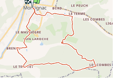
Tocht Stappen van 12,8 km beschikbaar op Nieuw-Aquitanië, Dordogne, Montignac-Lascaux. Deze tocht wordt voorgesteld door CC.RIDER.
Beschrijving
Une randonnée entre colline et vallon autour de la préhistoire.
Au départ de Montignac et autour du prestigieux site de Lascaux.
Plaatsbepaling
Land:
France
Regio :
Nieuw-Aquitanië
Departement/Provincie :
Dordogne
Gemeente :
Montignac-Lascaux
Locatie:
Unknown
Vertrek:(Dec)
Vertrek:(UTM)
355455 ; 4991687 (31T) N.
Opmerkingen
Wandeltochten in de omgeving
![Tocht Stappen Montignac-Lascaux - Balade Montignac Dordogne - Photo](https://media.geolcdn.com/t/375/260/df48718e-2f64-4737-9eaa-1f12102a550a.jpg&format=jpg&maxdim=2)
![Stappen Stappen](https://static1.geolcdn.com/sitytour/trail-icons/101.png)
Balade Montignac Dordogne
Stappen
Gemakkelijk
Montignac-Lascaux,
Nieuw-Aquitanië,
Dordogne,
France
![](/images/other/stat-length.png)
3 km | 3,8 km-effort
1h 17min
![](https://static1.geolcdn.com/siteimages/upload/files/16400158638029165_repeat_loop_refresh_sync_direction_icon.png)
Ja
![Tocht Stappen Thonac - vezere_28reduit - Photo](https://media.geolcdn.com/t/375/260/ext.jpg?maxdim=2&url=https%3A%2F%2Fstatic1.geolcdn.com%2Fsiteimages%2Fupload%2Ffiles%2F1553511878bg_sport_marche.png)
![Stappen Stappen](https://static1.geolcdn.com/sitytour/trail-icons/101.png)
vezere_28reduit
Stappen
Medium
(1)
Thonac,
Nieuw-Aquitanië,
Dordogne,
France
![](/images/other/stat-length.png)
9,2 km | 13,1 km-effort
2h 48min
![](https://static1.geolcdn.com/siteimages/upload/files/16400158638029165_repeat_loop_refresh_sync_direction_icon.png)
Ja
![Tocht Stappen Montignac-Lascaux - vezere_9 - Photo](https://media.geolcdn.com/t/375/260/ext.jpg?maxdim=2&url=https%3A%2F%2Fstatic1.geolcdn.com%2Fsiteimages%2Fupload%2Ffiles%2F1553511878bg_sport_marche.png)
![Stappen Stappen](https://static1.geolcdn.com/sitytour/trail-icons/101.png)
vezere_9
Stappen
Medium
(1)
Montignac-Lascaux,
Nieuw-Aquitanië,
Dordogne,
France
![](/images/other/stat-length.png)
13,5 km | 17,9 km-effort
3h 48min
![](https://static1.geolcdn.com/siteimages/upload/files/16400158638029165_repeat_loop_refresh_sync_direction_icon.png)
Ja
![Tocht Stappen Montignac-Lascaux - Montignac-peyzac - Photo](https://media.geolcdn.com/t/375/260/414c003e-9c11-405c-9eff-b9b60e428354.jpg&format=jpg&maxdim=2)
![Stappen Stappen](https://static1.geolcdn.com/sitytour/trail-icons/101.png)
Montignac-peyzac
Stappen
Medium
Montignac-Lascaux,
Nieuw-Aquitanië,
Dordogne,
France
![](/images/other/stat-length.png)
26 km | 36 km-effort
6h 57min
![](https://static1.geolcdn.com/siteimages/upload/files/16400158638029165_repeat_loop_refresh_sync_direction_icon.png)
Neen
![Tocht Stappen Aubas - Circuit des trois châteaux - Photo](https://media.geolcdn.com/t/375/260/a56ae793-bf88-4ec8-9fbe-a570eb23f704.jpg&format=jpg&maxdim=2)
![Stappen Stappen](https://static1.geolcdn.com/sitytour/trail-icons/101.png)
Circuit des trois châteaux
Stappen
Moeilijk
(2)
Aubas,
Nieuw-Aquitanië,
Dordogne,
France
![](/images/other/stat-length.png)
13,7 km | 18,1 km-effort
4h 7min
![](https://static1.geolcdn.com/siteimages/upload/files/16400158638029165_repeat_loop_refresh_sync_direction_icon.png)
Ja
![Tocht Stappen Montignac-Lascaux - Boucle de la Saladie - Photo](https://media.geolcdn.com/t/375/260/32a78e09-629c-4e47-bf36-86177a932ba8.jpg&format=jpg&maxdim=2)
![Stappen Stappen](https://static1.geolcdn.com/sitytour/trail-icons/101.png)
Boucle de la Saladie
Stappen
Zeer moeilijk
Montignac-Lascaux,
Nieuw-Aquitanië,
Dordogne,
France
![](/images/other/stat-length.png)
14,7 km | 19,4 km-effort
4h 25min
![](https://static1.geolcdn.com/siteimages/upload/files/16400158638029165_repeat_loop_refresh_sync_direction_icon.png)
Ja
![Tocht Stappen Thonac - Boucle de Maillol n°12 / Thonac - Photo](https://media.geolcdn.com/t/375/260/ext.jpg?maxdim=2&url=https%3A%2F%2Fstatic1.geolcdn.com%2Fsiteimages%2Fupload%2Ffiles%2F1553511878bg_sport_marche.png)
![Stappen Stappen](https://static1.geolcdn.com/sitytour/trail-icons/101.png)
Boucle de Maillol n°12 / Thonac
Stappen
Medium
Thonac,
Nieuw-Aquitanië,
Dordogne,
France
![](/images/other/stat-length.png)
8,4 km | 11 km-effort
2h 30min
![](https://static1.geolcdn.com/siteimages/upload/files/16400158638029165_repeat_loop_refresh_sync_direction_icon.png)
Neen
![Tocht Stappen Montignac-Lascaux - Autour de Lascaux 4 - Photo](https://media.geolcdn.com/t/375/260/ext.jpg?maxdim=2&url=https%3A%2F%2Fstatic1.geolcdn.com%2Fsiteimages%2Fupload%2Ffiles%2F1553511878bg_sport_marche.png)
![Stappen Stappen](https://static1.geolcdn.com/sitytour/trail-icons/101.png)
Autour de Lascaux 4
Stappen
Gemakkelijk
Montignac-Lascaux,
Nieuw-Aquitanië,
Dordogne,
France
![](/images/other/stat-length.png)
15,2 km | 19,9 km-effort
3h 56min
![](https://static1.geolcdn.com/siteimages/upload/files/16400158638029165_repeat_loop_refresh_sync_direction_icon.png)
Ja
![Tocht Stappen Auriac-du-Périgord - Auriac Azérat 16km - Photo](https://media.geolcdn.com/t/375/260/ext.jpg?maxdim=2&url=https%3A%2F%2Fstatic1.geolcdn.com%2Fsiteimages%2Fupload%2Ffiles%2F1553511878bg_sport_marche.png)
![Stappen Stappen](https://static1.geolcdn.com/sitytour/trail-icons/101.png)
Auriac Azérat 16km
Stappen
Gemakkelijk
Auriac-du-Périgord,
Nieuw-Aquitanië,
Dordogne,
France
![](/images/other/stat-length.png)
15,3 km | 21 km-effort
4h 11min
![](https://static1.geolcdn.com/siteimages/upload/files/16400158638029165_repeat_loop_refresh_sync_direction_icon.png)
Ja