![](/images/other/stat-length.png)
![Tocht Stappen Sewen - Massif du Ballon d'Alsace. Cirque glaciaire de l'Alfeld - Photo](https://media.geolcdn.com/t/1900/400/988bdb85-9e68-4bd6-9867-6a150e878f7c.jpg&format=pjpeg&maxdim=2)
Massif du Ballon d'Alsace. Cirque glaciaire de l'Alfeld
margotte
Gebruiker
![Lengte](/images/other/stat-length.png)
Lengte
13,3 km
![Max. hoogte](https://static1.geolcdn.com/siteimages/upload/files/1508320355ic_sort_altitude_max_24dp.png)
Max. hoogte
1115 m
![Positief hoogteverschil](https://static1.geolcdn.com/siteimages/upload/files/1508320355ic_sort_den_pos_24dp.png)
Positief hoogteverschil
680 m
![Km-Effort](/images/other/stat-length.png)
Km-Effort
22 km
![Min. hoogte](https://static1.geolcdn.com/siteimages/upload/files/1508320355ic_sort_altitude_min_24dp.png)
Min. hoogte
620 m
![Negatief hoogteverschil](https://static1.geolcdn.com/siteimages/upload/files/1508320355ic_sort_den_neg_24dp.png)
Negatief hoogteverschil
676 m
![Boucle](https://static1.geolcdn.com/siteimages/upload/files/16400158638029165_repeat_loop_refresh_sync_direction_icon.png)
Boucle
Ja
Datum van aanmaak :
2021-04-14 07:50:00.557
Laatste wijziging :
2021-04-16 18:27:29.437
![Stappen](https://static1.geolcdn.com/sitytour/trail-icons/101.png)
3h57
Moeilijkheid : Moeilijk
![Scan deze QR-code om de tocht te openen in de SityTrail-applicatie](https://capi.geolives.com/qq0zvz2zws4bq2lad0pu/sitytour/trails/2747018/qr.png?size=200)
Gratisgps-wandelapplicatie
Over ons
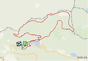
Tocht Stappen van 13,3 km beschikbaar op Grand Est, Haut-Rhin, Sewen. Deze tocht wordt voorgesteld door margotte.
Beschrijving
Parcours de montagne varié avec un étagement de végétation intéressant. De beaux sentiers comme on aime en parcourir en montagne. De beaux points de vue sur la vallée de la Doller.
Plaatsbepaling
Land:
France
Regio :
Grand Est
Departement/Provincie :
Haut-Rhin
Gemeente :
Sewen
Locatie:
Unknown
Vertrek:(Dec)
Vertrek:(UTM)
339875 ; 5297927 (32T) N.
Opmerkingen
Wandeltochten in de omgeving
![Tocht Stappen Saint-Maurice-sur-Moselle - Tour du Ballon d'Alsace - Photo](https://media.geolcdn.com/t/375/260/ext.jpg?maxdim=2&url=https%3A%2F%2Fservices.sitytrail.com%2FGeolivesWS%2FDownloadMedia.ashx%3FTrailID%3D450011%26Media%3Dfix__20150716161020.jpg)
![Stappen Stappen](https://static1.geolcdn.com/sitytour/trail-icons/101.png)
Tour du Ballon d'Alsace
Stappen
Moeilijk
(1)
Saint-Maurice-sur-Moselle,
Grand Est,
Vogezen,
France
![](/images/other/stat-length.png)
10,5 km | 17,7 km-effort
5h 25min
![](https://static1.geolcdn.com/siteimages/upload/files/16400158638029165_repeat_loop_refresh_sync_direction_icon.png)
Ja
![Tocht Stappen Sewen - Boucle entre les lacs de Sewen et d'Alfeld - Photo](https://media.geolcdn.com/t/375/260/ext.jpg?maxdim=2&url=https%3A%2F%2Fservices.sitytrail.com%2FGeolivesWS%2FDownloadMedia.ashx%3FTrailID%3D103686%26Media%3D6168_4.jpg)
![Stappen Stappen](https://static1.geolcdn.com/sitytour/trail-icons/101.png)
Boucle entre les lacs de Sewen et d'Alfeld
Stappen
Medium
(1)
Sewen,
Grand Est,
Haut-Rhin,
France
![](/images/other/stat-length.png)
8,1 km | 12,3 km-effort
2h 30min
![](https://static1.geolcdn.com/siteimages/upload/files/16400158638029165_repeat_loop_refresh_sync_direction_icon.png)
Ja
![Tocht Stappen Sewen - lac d'Alfeld - Photo](https://media.geolcdn.com/t/375/260/f10be3b8-650f-4f78-b860-6c956e66a815.jpg&format=jpg&maxdim=2)
![Stappen Stappen](https://static1.geolcdn.com/sitytour/trail-icons/101.png)
lac d'Alfeld
Stappen
Zeer moeilijk
(1)
Sewen,
Grand Est,
Haut-Rhin,
France
![](/images/other/stat-length.png)
17,1 km | 28 km-effort
8h 7min
![](https://static1.geolcdn.com/siteimages/upload/files/16400158638029165_repeat_loop_refresh_sync_direction_icon.png)
Ja
![Tocht Stappen Storckensohn - lac des perches marchettes - Photo](https://media.geolcdn.com/t/375/260/ba8e93c4-c66a-48b1-88b8-cca79cc3effc.jpg&format=jpg&maxdim=2)
![Stappen Stappen](https://static1.geolcdn.com/sitytour/trail-icons/101.png)
lac des perches marchettes
Stappen
Medium
(1)
Storckensohn,
Grand Est,
Haut-Rhin,
France
![](/images/other/stat-length.png)
11,9 km | 20 km-effort
4h 8min
![](https://static1.geolcdn.com/siteimages/upload/files/16400158638029165_repeat_loop_refresh_sync_direction_icon.png)
Ja
![Tocht Stappen Lepuix - Le Tremontkopf - Photo](https://media.geolcdn.com/t/375/260/ext.jpg?maxdim=2&url=https%3A%2F%2Fservices.sitytrail.com%2FGeolivesWS%2FDownloadMedia.ashx%3FTrailID%3D109649%26Media%3D4290_1.jpg)
![Stappen Stappen](https://static1.geolcdn.com/sitytour/trail-icons/101.png)
Le Tremontkopf
Stappen
Medium
(1)
Lepuix,
Bourgondië-Franche-Comté,
Territoire-de-Belfort,
France
![](/images/other/stat-length.png)
9,1 km | 17,3 km-effort
3h 0min
![](https://static1.geolcdn.com/siteimages/upload/files/16400158638029165_repeat_loop_refresh_sync_direction_icon.png)
Ja
![Tocht Stappen Plancher-les-Mines - 2025-01-04 Rando Polaire Dolleren Ballon Alsace Etape 3 - Photo](https://media.geolcdn.com/t/375/260/2540e417-a017-45ca-bf10-302bab8725fa.jpg&format=jpg&maxdim=2)
![Stappen Stappen](https://static1.geolcdn.com/sitytour/trail-icons/101.png)
2025-01-04 Rando Polaire Dolleren Ballon Alsace Etape 3
Stappen
Zeer moeilijk
Plancher-les-Mines,
Bourgondië-Franche-Comté,
Haute-Saône,
France
![](/images/other/stat-length.png)
18,6 km | 30 km-effort
6h 52min
![](https://static1.geolcdn.com/siteimages/upload/files/16400158638029165_repeat_loop_refresh_sync_direction_icon.png)
Neen
![Tocht Stappen Dolleren - 2025-01-03 Rando Polaire Dolleren Ballon Alsace Etape 2 - Photo](https://media.geolcdn.com/t/375/260/9acfce3f-2eaf-4a63-8eb3-62065bd107c3.jpg&format=jpg&maxdim=2)
![Stappen Stappen](https://static1.geolcdn.com/sitytour/trail-icons/101.png)
2025-01-03 Rando Polaire Dolleren Ballon Alsace Etape 2
Stappen
Zeer moeilijk
Dolleren,
Grand Est,
Haut-Rhin,
France
![](/images/other/stat-length.png)
17,3 km | 26 km-effort
6h 0min
![](https://static1.geolcdn.com/siteimages/upload/files/16400158638029165_repeat_loop_refresh_sync_direction_icon.png)
Neen
![Tocht Stappen Dolleren - suuntoapp-Hiking-2025-01-02T19-20-24Z - Photo](https://media.geolcdn.com/t/375/260/98b6c1e4-75f0-464a-86a1-edc427e75210.jpg&format=jpg&maxdim=2)
![Stappen Stappen](https://static1.geolcdn.com/sitytour/trail-icons/101.png)
suuntoapp-Hiking-2025-01-02T19-20-24Z
Stappen
Medium
Dolleren,
Grand Est,
Haut-Rhin,
France
![](/images/other/stat-length.png)
4,3 km | 8,1 km-effort
1h 50min
![](https://static1.geolcdn.com/siteimages/upload/files/16400158638029165_repeat_loop_refresh_sync_direction_icon.png)
Neen
![Mountainbike Mountainbike](https://static1.geolcdn.com/sitytour/trail-icons/202.png)
SityTrail - 3248441 - documentxix745004916x3256137
Mountainbike
Medium
Saint-Maurice-sur-Moselle,
Grand Est,
Vogezen,
France
![](/images/other/stat-length.png)
21 km | 30 km-effort
2h 3min
![](https://static1.geolcdn.com/siteimages/upload/files/16400158638029165_repeat_loop_refresh_sync_direction_icon.png)
Ja