![](/images/other/stat-length.png)
![Tocht Stappen Bassillac et Auberoche - 2021-04-13_18h52m44_gpx-trace - Photo](https://media.geolcdn.com/t/1900/400/ext.pjpeg?maxdim=2&url=https%3A%2F%2Fstatic1.geolcdn.com%2Fsiteimages%2Fupload%2Ffiles%2F1553511878bg_sport_marche.png)
2021-04-13_18h52m44_gpx-trace
swp648
Gebruiker
![Lengte](/images/other/stat-length.png)
Lengte
13 km
![Max. hoogte](https://static1.geolcdn.com/siteimages/upload/files/1508320355ic_sort_altitude_max_24dp.png)
Max. hoogte
234 m
![Positief hoogteverschil](https://static1.geolcdn.com/siteimages/upload/files/1508320355ic_sort_den_pos_24dp.png)
Positief hoogteverschil
336 m
![Km-Effort](/images/other/stat-length.png)
Km-Effort
17,4 km
![Min. hoogte](https://static1.geolcdn.com/siteimages/upload/files/1508320355ic_sort_altitude_min_24dp.png)
Min. hoogte
110 m
![Negatief hoogteverschil](https://static1.geolcdn.com/siteimages/upload/files/1508320355ic_sort_den_neg_24dp.png)
Negatief hoogteverschil
337 m
![Boucle](https://static1.geolcdn.com/siteimages/upload/files/16400158638029165_repeat_loop_refresh_sync_direction_icon.png)
Boucle
Ja
Datum van aanmaak :
2021-04-13 16:52:45.773
Laatste wijziging :
2021-04-13 17:02:39.401
![Stappen](https://static1.geolcdn.com/sitytour/trail-icons/101.png)
3h57
Moeilijkheid : Gemakkelijk
![Scan deze QR-code om de tocht te openen in de SityTrail-applicatie](https://capi.geolives.com/qq0zvz2zws4bq2lad0pu/sitytour/trails/2746194/qr.png?size=200)
Gratisgps-wandelapplicatie
Over ons
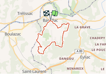
Tocht Stappen van 13 km beschikbaar op Nieuw-Aquitanië, Dordogne, Bassillac et Auberoche. Deze tocht wordt voorgesteld door swp648.
Beschrijving
Départ du parking de la mairie (escalier à gauche en montant) à Bassillac
Circuit qui emprunte en partie le circuit mémorial de la résistance locale.
Plaatsbepaling
Land:
France
Regio :
Nieuw-Aquitanië
Departement/Provincie :
Dordogne
Gemeente :
Bassillac et Auberoche
Locatie:
Unknown
Vertrek:(Dec)
Vertrek:(UTM)
328244 ; 5006563 (31T) N.
Opmerkingen
Wandeltochten in de omgeving
![Tocht Stappen Trélissac - Trélissac Puyconteau 10km - Photo](https://media.geolcdn.com/t/375/260/ext.jpg?maxdim=2&url=https%3A%2F%2Fstatic1.geolcdn.com%2Fsiteimages%2Fupload%2Ffiles%2F1553511878bg_sport_marche.png)
![Stappen Stappen](https://static1.geolcdn.com/sitytour/trail-icons/101.png)
Trélissac Puyconteau 10km
Stappen
Gemakkelijk
(2)
Trélissac,
Nieuw-Aquitanië,
Dordogne,
France
![](/images/other/stat-length.png)
9,7 km | 12,7 km-effort
2h 44min
![](https://static1.geolcdn.com/siteimages/upload/files/16400158638029165_repeat_loop_refresh_sync_direction_icon.png)
Ja
![Tocht Noords wandelen Antonne-et-Trigonant - Lanmary Sibaudie à l'envers - Photo](https://media.geolcdn.com/t/375/260/ext.jpg?maxdim=2&url=https%3A%2F%2Fstatic1.geolcdn.com%2Fsiteimages%2Fupload%2Ffiles%2F1545311037marcheuse_200dpi.jpg)
![Noords wandelen Noords wandelen](https://static1.geolcdn.com/sitytour/trail-icons/102.png)
Lanmary Sibaudie à l'envers
Noords wandelen
Heel gemakkelijk
(2)
Antonne-et-Trigonant,
Nieuw-Aquitanië,
Dordogne,
France
![](/images/other/stat-length.png)
11,8 km | 15,1 km-effort
2h 51min
![](https://static1.geolcdn.com/siteimages/upload/files/16400158638029165_repeat_loop_refresh_sync_direction_icon.png)
Ja
![Tocht Noords wandelen Antonne-et-Trigonant - Lanmary 8,7 km - Photo](https://media.geolcdn.com/t/375/260/ext.jpg?maxdim=2&url=https%3A%2F%2Fstatic1.geolcdn.com%2Fsiteimages%2Fupload%2Ffiles%2F1545311037marcheuse_200dpi.jpg)
![Noords wandelen Noords wandelen](https://static1.geolcdn.com/sitytour/trail-icons/102.png)
Lanmary 8,7 km
Noords wandelen
Gemakkelijk
(1)
Antonne-et-Trigonant,
Nieuw-Aquitanië,
Dordogne,
France
![](/images/other/stat-length.png)
8,7 km | 10,5 km-effort
1h 58min
![](https://static1.geolcdn.com/siteimages/upload/files/16400158638029165_repeat_loop_refresh_sync_direction_icon.png)
Ja
![Tocht Noords wandelen Trélissac - petite - Photo](https://media.geolcdn.com/t/375/260/ext.jpg?maxdim=2&url=https%3A%2F%2Fstatic1.geolcdn.com%2Fsiteimages%2Fupload%2Ffiles%2F1545311037marcheuse_200dpi.jpg)
![Noords wandelen Noords wandelen](https://static1.geolcdn.com/sitytour/trail-icons/102.png)
petite
Noords wandelen
Heel gemakkelijk
(1)
Trélissac,
Nieuw-Aquitanië,
Dordogne,
France
![](/images/other/stat-length.png)
8,6 km | 11,7 km-effort
1h 59min
![](https://static1.geolcdn.com/siteimages/upload/files/16400158638029165_repeat_loop_refresh_sync_direction_icon.png)
Neen
![Tocht Noords wandelen Antonne-et-Trigonant - lanmary 9.7 - Photo](https://media.geolcdn.com/t/375/260/ext.jpg?maxdim=2&url=https%3A%2F%2Fstatic1.geolcdn.com%2Fsiteimages%2Fupload%2Ffiles%2F1545311037marcheuse_200dpi.jpg)
![Noords wandelen Noords wandelen](https://static1.geolcdn.com/sitytour/trail-icons/102.png)
lanmary 9.7
Noords wandelen
Heel gemakkelijk
(1)
Antonne-et-Trigonant,
Nieuw-Aquitanië,
Dordogne,
France
![](/images/other/stat-length.png)
9,8 km | 12,2 km-effort
2h 13min
![](https://static1.geolcdn.com/siteimages/upload/files/16400158638029165_repeat_loop_refresh_sync_direction_icon.png)
Ja
![Tocht Noords wandelen Antonne-et-Trigonant - lanmary 11 km - Photo](https://media.geolcdn.com/t/375/260/ext.jpg?maxdim=2&url=https%3A%2F%2Fstatic1.geolcdn.com%2Fsiteimages%2Fupload%2Ffiles%2F1545311037marcheuse_200dpi.jpg)
![Noords wandelen Noords wandelen](https://static1.geolcdn.com/sitytour/trail-icons/102.png)
lanmary 11 km
Noords wandelen
Heel gemakkelijk
(1)
Antonne-et-Trigonant,
Nieuw-Aquitanië,
Dordogne,
France
![](/images/other/stat-length.png)
11,1 km | 13,7 km-effort
2h 39min
![](https://static1.geolcdn.com/siteimages/upload/files/16400158638029165_repeat_loop_refresh_sync_direction_icon.png)
Ja
![Tocht Noords wandelen Antonne-et-Trigonant - Croix du Rat - Photo](https://media.geolcdn.com/t/375/260/ext.jpg?maxdim=2&url=https%3A%2F%2Fstatic1.geolcdn.com%2Fsiteimages%2Fupload%2Ffiles%2F1545311037marcheuse_200dpi.jpg)
![Noords wandelen Noords wandelen](https://static1.geolcdn.com/sitytour/trail-icons/102.png)
Croix du Rat
Noords wandelen
Heel gemakkelijk
(1)
Antonne-et-Trigonant,
Nieuw-Aquitanië,
Dordogne,
France
![](/images/other/stat-length.png)
10,8 km | 13,4 km-effort
2h 28min
![](https://static1.geolcdn.com/siteimages/upload/files/16400158638029165_repeat_loop_refresh_sync_direction_icon.png)
Ja
![Tocht Stappen Boulazac Isle Manoire - Boulazac à partir du Palio - Photo](https://media.geolcdn.com/t/375/260/ext.jpg?maxdim=2&url=https%3A%2F%2Fservices.sitytrail.com%2FGeolivesWS%2FDownloadMedia.ashx%3FTrailID%3D317879%26Media%3D17272_6.jpg)
![Stappen Stappen](https://static1.geolcdn.com/sitytour/trail-icons/101.png)
Boulazac à partir du Palio
Stappen
Medium
(1)
Boulazac Isle Manoire,
Nieuw-Aquitanië,
Dordogne,
France
![](/images/other/stat-length.png)
7,3 km | 9 km-effort
1h 45min
![](https://static1.geolcdn.com/siteimages/upload/files/16400158638029165_repeat_loop_refresh_sync_direction_icon.png)
Ja
![Tocht Stappen Boulazac Isle Manoire - Octobre rose Boulazac 2022 - Photo](https://media.geolcdn.com/t/375/260/e41a1f45-65e7-47fa-b801-6540904164c7.jpg&format=jpg&maxdim=2)
![Stappen Stappen](https://static1.geolcdn.com/sitytour/trail-icons/101.png)
Octobre rose Boulazac 2022
Stappen
Gemakkelijk
Boulazac Isle Manoire,
Nieuw-Aquitanië,
Dordogne,
France
![](/images/other/stat-length.png)
7,7 km | 8,9 km-effort
1h 42min
![](https://static1.geolcdn.com/siteimages/upload/files/16400158638029165_repeat_loop_refresh_sync_direction_icon.png)
Ja