![](/images/other/stat-length.png)
![Tocht Stappen Sainte-Ode - Etape 2 - Photo](https://media.geolcdn.com/t/1900/400/b7f49ad0-51d7-4be7-8b63-64044ccaae57.jpg&format=pjpeg&maxdim=2)
Etape 2
beautrix
Gebruiker
![Lengte](/images/other/stat-length.png)
Lengte
21 km
![Max. hoogte](https://static1.geolcdn.com/siteimages/upload/files/1508320355ic_sort_altitude_max_24dp.png)
Max. hoogte
565 m
![Positief hoogteverschil](https://static1.geolcdn.com/siteimages/upload/files/1508320355ic_sort_den_pos_24dp.png)
Positief hoogteverschil
481 m
![Km-Effort](/images/other/stat-length.png)
Km-Effort
27 km
![Min. hoogte](https://static1.geolcdn.com/siteimages/upload/files/1508320355ic_sort_altitude_min_24dp.png)
Min. hoogte
364 m
![Negatief hoogteverschil](https://static1.geolcdn.com/siteimages/upload/files/1508320355ic_sort_den_neg_24dp.png)
Negatief hoogteverschil
433 m
![Boucle](https://static1.geolcdn.com/siteimages/upload/files/16400158638029165_repeat_loop_refresh_sync_direction_icon.png)
Boucle
Neen
Datum van aanmaak :
2021-04-11 17:14:49.078
Laatste wijziging :
2021-04-18 07:35:20.875
![Stappen](https://static1.geolcdn.com/sitytour/trail-icons/101.png)
6h11
Moeilijkheid : Medium
![Scan deze QR-code om de tocht te openen in de SityTrail-applicatie](https://capi.geolives.com/qq0zvz2zws4bq2lad0pu/sitytour/trails/2743817/qr.png?size=200)
Gratisgps-wandelapplicatie
Over ons
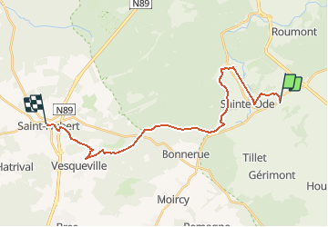
Tocht Stappen van 21 km beschikbaar op Wallonië, Luxemburg, Sainte-Ode. Deze tocht wordt voorgesteld door beautrix.
Beschrijving
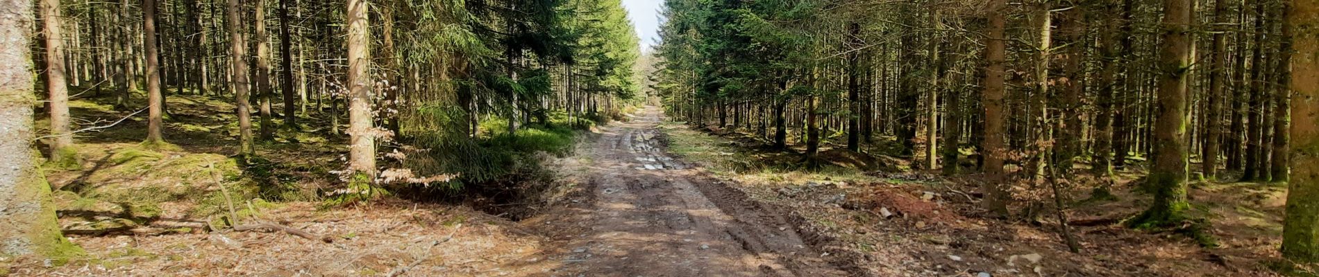
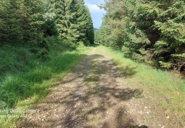
Tracé quasi exclusivement en forêt avec la traversée rapide quelques villages. Prévoir ravitaillement complet pour la journée. Possibilité d'apercevoir le travail des castors à plusieurs endroits sur l'itinéraire !
Plaatsbepaling
Land:
Belgium
Regio :
Wallonië
Departement/Provincie :
Luxemburg
Gemeente :
Sainte-Ode
Locatie:
Amberloup
Vertrek:(Dec)
Vertrek:(UTM)
682513 ; 5545800 (31U) N.
Opmerkingen
Wandeltochten in de omgeving
![Tocht Stappen Sainte-Ode - RB-LUX-08 - Raccourci - De part et d’autre de l’Ourthe occidentale - Photo](https://media.geolcdn.com/t/375/260/ext.jpg?maxdim=2&url=https%3A%2F%2Fservices.sitytrail.com%2FGeolivesWS%2FDownloadMedia.ashx%3FTrailID%3D216067%26Media%3Da5159bed-d44e-45f6-91bf-98d2633ab672.jpg)
![Stappen Stappen](https://static1.geolcdn.com/sitytour/trail-icons/101.png)
RB-LUX-08 - Raccourci - De part et d’autre de l’Ourthe occidentale
Stappen
Moeilijk
(2)
Sainte-Ode,
Wallonië,
Luxemburg,
Belgium
![](/images/other/stat-length.png)
15,2 km | 18,6 km-effort
4h 13min
![](https://static1.geolcdn.com/siteimages/upload/files/16400158638029165_repeat_loop_refresh_sync_direction_icon.png)
Ja
![Tocht Stappen Sainte-Ode - Wandeling van Tonny - Photo](https://media.geolcdn.com/t/375/260/ext.jpg?maxdim=2&url=https%3A%2F%2Fservices.sitytrail.com%2FGeolivesWS%2FDownloadMedia.ashx%3FTrailID%3D470390%26Media%3D36d9826a-10d7-493f-bb50-7affdbc9817f.jpg)
![Stappen Stappen](https://static1.geolcdn.com/sitytour/trail-icons/101.png)
Wandeling van Tonny
Stappen
Medium
(3)
Sainte-Ode,
Wallonië,
Luxemburg,
Belgium
![](/images/other/stat-length.png)
9,5 km | 12,2 km-effort
2h 36min
![](https://static1.geolcdn.com/siteimages/upload/files/16400158638029165_repeat_loop_refresh_sync_direction_icon.png)
Ja
![Tocht Stappen Sainte-Ode - Beauplateau - Wandeling](https://media.geolcdn.com/t/375/260/ext.jpg?maxdim=2&url=https%3A%2F%2Fservices.sitytrail.com%2FGeolivesWS%2FDownloadMedia.ashx%3FTrailID%3D334523%26Media%3D18a8c2b6-d141-493c-b9d2-49dc585d80d8.JPG)
![Stappen Stappen](https://static1.geolcdn.com/sitytour/trail-icons/101.png)
Beauplateau - Wandeling "du Pleurotte" (T7)
Stappen
Medium
(3)
Sainte-Ode,
Wallonië,
Luxemburg,
Belgium
![](/images/other/stat-length.png)
5,5 km | 6,9 km-effort
1h 29min
![](https://static1.geolcdn.com/siteimages/upload/files/16400158638029165_repeat_loop_refresh_sync_direction_icon.png)
Ja
![Tocht Stappen Sainte-Ode - Sainte-Ode - Wandeling van de Bonne Dame - Photo](https://media.geolcdn.com/t/375/260/ext.jpg?maxdim=2&url=https%3A%2F%2Fservices.sitytrail.com%2FGeolivesWS%2FDownloadMedia.ashx%3FTrailID%3D334508%26Media%3Dbeafdf5d-7e56-47ba-baef-9d2f39d35ed9.png)
![Stappen Stappen](https://static1.geolcdn.com/sitytour/trail-icons/101.png)
Sainte-Ode - Wandeling van de Bonne Dame
Stappen
Medium
(5)
Sainte-Ode,
Wallonië,
Luxemburg,
Belgium
![](/images/other/stat-length.png)
7,7 km | 10 km-effort
2h 10min
![](https://static1.geolcdn.com/siteimages/upload/files/16400158638029165_repeat_loop_refresh_sync_direction_icon.png)
Ja
![Tocht Stappen Sainte-Ode - Amberloup, Natura 2000 - Des sites qui valent le détour. Lx11 - Photo](https://media.geolcdn.com/t/375/260/ext.jpg?maxdim=2&url=https%3A%2F%2Fservices.sitytrail.com%2FGeolivesWS%2FDownloadMedia.ashx%3FTrailID%3D181909%26Media%3Dd96a433d-6654-4704-ae71-038ac1db039e.JPG)
![Stappen Stappen](https://static1.geolcdn.com/sitytour/trail-icons/101.png)
Amberloup, Natura 2000 - Des sites qui valent le détour. Lx11
Stappen
Gemakkelijk
(4)
Sainte-Ode,
Wallonië,
Luxemburg,
Belgium
![](/images/other/stat-length.png)
4,2 km | 5 km-effort
1h 6min
![](https://static1.geolcdn.com/siteimages/upload/files/16400158638029165_repeat_loop_refresh_sync_direction_icon.png)
Ja
![Tocht Stappen Sainte-Ode - RB-LUX-08 - De part et d’autre de l’Ourthe occidentale - Photo](https://media.geolcdn.com/t/375/260/ext.jpg?maxdim=2&url=https%3A%2F%2Fservices.sitytrail.com%2FGeolivesWS%2FDownloadMedia.ashx%3FTrailID%3D179624%26Media%3D32148395-8c8d-48d3-9d07-5af495614365.jpg)
![Stappen Stappen](https://static1.geolcdn.com/sitytour/trail-icons/101.png)
RB-LUX-08 - De part et d’autre de l’Ourthe occidentale
Stappen
Medium
(1)
Sainte-Ode,
Wallonië,
Luxemburg,
Belgium
![](/images/other/stat-length.png)
23 km | 29 km-effort
6h 14min
![](https://static1.geolcdn.com/siteimages/upload/files/16400158638029165_repeat_loop_refresh_sync_direction_icon.png)
Ja
![Tocht Stappen Sainte-Ode - rando lavacherie 5-02-2022 - Photo](https://media.geolcdn.com/t/375/260/51d83bb4-0870-46ee-b60b-b2146d049ac2.jpg&format=jpg&maxdim=2)
![Stappen Stappen](https://static1.geolcdn.com/sitytour/trail-icons/101.png)
rando lavacherie 5-02-2022
Stappen
Medium
(1)
Sainte-Ode,
Wallonië,
Luxemburg,
Belgium
![](/images/other/stat-length.png)
8,6 km | 12,1 km-effort
2h 17min
![](https://static1.geolcdn.com/siteimages/upload/files/16400158638029165_repeat_loop_refresh_sync_direction_icon.png)
Ja
![Tocht Stappen Sainte-Ode - rando lavacherie 29/08/2020 - Photo](https://media.geolcdn.com/t/375/260/748c1b0e-fc3a-4c4c-86ea-3c557994f8d1.jpg&format=jpg&maxdim=2)
![Stappen Stappen](https://static1.geolcdn.com/sitytour/trail-icons/101.png)
rando lavacherie 29/08/2020
Stappen
Medium
(1)
Sainte-Ode,
Wallonië,
Luxemburg,
Belgium
![](/images/other/stat-length.png)
15,3 km | 20 km-effort
3h 15min
![](https://static1.geolcdn.com/siteimages/upload/files/16400158638029165_repeat_loop_refresh_sync_direction_icon.png)
Ja
![Tocht Te voet Sainte-Ode - Dans Freyr par Bokaissart - Photo](https://media.geolcdn.com/t/375/260/2729b0ca-029d-4d17-86fa-7ef36ad5b1f3.jpg&format=jpg&maxdim=2)
![Te voet Te voet](https://static1.geolcdn.com/sitytour/trail-icons/100.png)
Dans Freyr par Bokaissart
Te voet
Medium
(1)
Sainte-Ode,
Wallonië,
Luxemburg,
Belgium
![](/images/other/stat-length.png)
4,6 km | 5,9 km-effort
1h 25min
![](https://static1.geolcdn.com/siteimages/upload/files/16400158638029165_repeat_loop_refresh_sync_direction_icon.png)
Ja