![](/images/other/stat-length.png)
![Tocht Stappen Clécy - CLECY - Photo](https://media.geolcdn.com/t/1900/400/47a84116-8dc1-4708-abfe-8162e1a0acd4.jpg&format=pjpeg&maxdim=2)
CLECY
yannick-p
Gebruiker
![Lengte](/images/other/stat-length.png)
![Max. hoogte](https://static1.geolcdn.com/siteimages/upload/files/1508320355ic_sort_altitude_max_24dp.png)
![Positief hoogteverschil](https://static1.geolcdn.com/siteimages/upload/files/1508320355ic_sort_den_pos_24dp.png)
![Km-Effort](/images/other/stat-length.png)
![Min. hoogte](https://static1.geolcdn.com/siteimages/upload/files/1508320355ic_sort_altitude_min_24dp.png)
![Negatief hoogteverschil](https://static1.geolcdn.com/siteimages/upload/files/1508320355ic_sort_den_neg_24dp.png)
![Boucle](https://static1.geolcdn.com/siteimages/upload/files/16400158638029165_repeat_loop_refresh_sync_direction_icon.png)
![Stappen](https://static1.geolcdn.com/sitytour/trail-icons/101.png)
4h01
Moeilijkheid : Moeilijk
![Geocaching](https://static1.geolcdn.com/sitytour/trail-icons/908.png)
5h20
Moeilijkheid : Moeilijk
![Scan deze QR-code om de tocht te openen in de SityTrail-applicatie](https://capi.geolives.com/qq0zvz2zws4bq2lad0pu/sitytour/trails/274123/qr.png?size=200)
Gratisgps-wandelapplicatie
Over ons
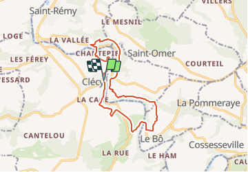
Tocht Stappen van 12,7 km beschikbaar op Normandië, Calvados, Clécy. Deze tocht wordt voorgesteld door yannick-p.
Beschrijving
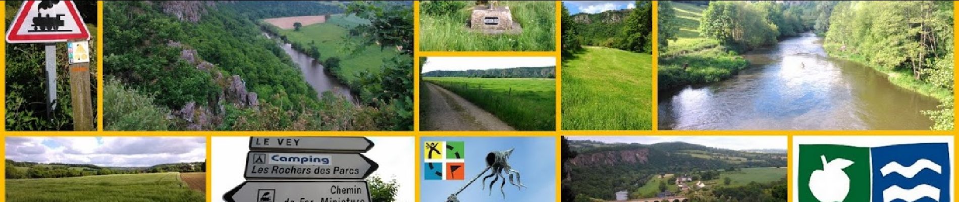
Nouveauté 2021 : Le parcours comprend 34 caches, dont 1 cache mystère (la Bonus), 1 multicache et 1 earthcache.
🌻🦅1 @ Clecy - Départ 🧗🚶
🌻🦅 2@ Clecy - Placy 🧗🚶
🌻🦅 6@ Clecy - Suisse Normande 🧗🚶-
🌻🦅 12 @ Clecy - Le Moulin du Vey 🧗🚶
🌻🦅 13 @ Clecy - La Voie SNCF 🧗🚶
Caches supplémentaires :
🌻🦅 6 bis @ Clecy - Suisse Normande 🧗🚶
🌻🦅 10 bis @ Clecy - GR 36 🧗🚶
🌻🦅 11 bis @ Clecy - Le Physicien 🧗🚶
Une petite earthcache au passage, en cours d'examen :
27 @ Clecy 🌍 La barre des Rochers des Parcs 🌍
Clécy - Suisse Normande
Clécy est située sur l'Orne, au cœur de la Suisse normande, à 35 kilomètres au sud de Caen. Couvrant 2 463 hectares, le territoire communal est le plus étendu du canton de Thury-Harcourt.
Titré Capitale de la Suisse normande, ce village doit son renom au relief accidenté et verdoyant du massif armoricain, avec des gorges dans lesquelles circule l'Orne.
De nombreuses activités de plein air s'y développent : canoë-kayak, parapente, escalade, randonnées pédestres et VTT... profitant ainsi de la typicité géologique de la Suisse normande.
Bonnes recherches et bonnes découvertes !!!
Plaatsbepaling
Opmerkingen
Wandeltochten in de omgeving
![Tocht Mountainbike Saint-Omer - Espace VTT FFC de Suisse Normande - Circuit 11 - Saint Omer - Photo](https://media.geolcdn.com/t/375/260/ext.jpg?maxdim=2&url=https%3A%2F%2Fservices.sitytrail.com%2FGeolivesWS%2FDownloadMedia.ashx%3FTrailID%3D106820%26Media%3D11522_1.jpg)
![Mountainbike Mountainbike](https://static1.geolcdn.com/sitytour/trail-icons/202.png)
Mountainbike
![](/images/other/stat-length.png)
![](https://static1.geolcdn.com/siteimages/upload/files/16400158638029165_repeat_loop_refresh_sync_direction_icon.png)
![Tocht Stappen Le Vey - Clécy - Photo](https://media.geolcdn.com/t/375/260/128372da-8bde-41a3-bf52-ea6a6766f39f.jpg&format=jpg&maxdim=2)
![Stappen Stappen](https://static1.geolcdn.com/sitytour/trail-icons/101.png)
Stappen
![](/images/other/stat-length.png)
![](https://static1.geolcdn.com/siteimages/upload/files/16400158638029165_repeat_loop_refresh_sync_direction_icon.png)
![Tocht Te voet Culey-le-Patry - Le Mouin du Fay - Photo](https://media.geolcdn.com/t/375/260/eb1521b3-cf98-4c55-9410-8de821da7add.jpeg&format=jpg&maxdim=2)
![Te voet Te voet](https://static1.geolcdn.com/sitytour/trail-icons/100.png)
Te voet
![](/images/other/stat-length.png)
![](https://static1.geolcdn.com/siteimages/upload/files/16400158638029165_repeat_loop_refresh_sync_direction_icon.png)
![Tocht Te voet Le Bô - Des Montagnes de Normandie? - Photo](https://media.geolcdn.com/t/375/260/99446ac7-841c-43b2-a8d0-7ad8496245d0.jpeg&format=jpg&maxdim=2)
![Te voet Te voet](https://static1.geolcdn.com/sitytour/trail-icons/100.png)
Te voet
![](/images/other/stat-length.png)
![](https://static1.geolcdn.com/siteimages/upload/files/16400158638029165_repeat_loop_refresh_sync_direction_icon.png)
![Tocht Te voet Esson - La Chapelle Bonne Nouvelle - Photo](https://media.geolcdn.com/t/375/260/82717480-a9c2-41c9-93af-e42d631dbd18.jpeg&format=jpg&maxdim=2)
![Te voet Te voet](https://static1.geolcdn.com/sitytour/trail-icons/100.png)
Te voet
![](/images/other/stat-length.png)
![](https://static1.geolcdn.com/siteimages/upload/files/16400158638029165_repeat_loop_refresh_sync_direction_icon.png)
![Tocht Te voet La Pommeraye - Les Rochers de Briesvieille - Photo](https://media.geolcdn.com/t/375/260/99446ac7-841c-43b2-a8d0-7ad8496245d0.jpeg&format=jpg&maxdim=2)
![Te voet Te voet](https://static1.geolcdn.com/sitytour/trail-icons/100.png)
Te voet
![](/images/other/stat-length.png)
![](https://static1.geolcdn.com/siteimages/upload/files/16400158638029165_repeat_loop_refresh_sync_direction_icon.png)
![Tocht Te voet Le Bô - Le Moulin à Papier - Photo](https://media.geolcdn.com/t/375/260/3ac248d0-9006-472c-b1a7-3308f2fe9984.jpeg&format=jpg&maxdim=2)
![Te voet Te voet](https://static1.geolcdn.com/sitytour/trail-icons/100.png)
Te voet
![](/images/other/stat-length.png)
![](https://static1.geolcdn.com/siteimages/upload/files/16400158638029165_repeat_loop_refresh_sync_direction_icon.png)
![Tocht Te voet Esson - GRP Tour de la Suisse Normande - Photo](https://media.geolcdn.com/t/375/260/96471841-70b2-445a-bcf9-e6471b393594.jpeg&format=jpg&maxdim=2)
![Te voet Te voet](https://static1.geolcdn.com/sitytour/trail-icons/100.png)
Te voet
![](/images/other/stat-length.png)
![](https://static1.geolcdn.com/siteimages/upload/files/16400158638029165_repeat_loop_refresh_sync_direction_icon.png)
![Tocht Mountainbike Saint-Rémy - VTT Suisse Normande N°10 - St Rémy sur Orne - Photo](https://media.geolcdn.com/t/375/260/ext.jpg?maxdim=2&url=https%3A%2F%2Fservices.sitytrail.com%2FGeolivesWS%2FDownloadMedia.ashx%3FTrailID%3D173106%26Media%3D14655_3.jpg)
![Mountainbike Mountainbike](https://static1.geolcdn.com/sitytour/trail-icons/202.png)
Mountainbike
![](/images/other/stat-length.png)
![](https://static1.geolcdn.com/siteimages/upload/files/16400158638029165_repeat_loop_refresh_sync_direction_icon.png)