![](/images/other/stat-length.png)
![Tocht Stappen Le Bar-sur-Loup - Canal du Foulon, bois de la Marbrière, St Christophe - Photo](https://media.geolcdn.com/t/1900/400/c4a7df15-b308-4de7-9bfb-3e2422229210.jpg&format=pjpeg&maxdim=2)
Canal du Foulon, bois de la Marbrière, St Christophe
domi06
Gebruiker
![Lengte](/images/other/stat-length.png)
![Max. hoogte](https://static1.geolcdn.com/siteimages/upload/files/1508320355ic_sort_altitude_max_24dp.png)
![Positief hoogteverschil](https://static1.geolcdn.com/siteimages/upload/files/1508320355ic_sort_den_pos_24dp.png)
![Km-Effort](/images/other/stat-length.png)
![Min. hoogte](https://static1.geolcdn.com/siteimages/upload/files/1508320355ic_sort_altitude_min_24dp.png)
![Negatief hoogteverschil](https://static1.geolcdn.com/siteimages/upload/files/1508320355ic_sort_den_neg_24dp.png)
![Boucle](https://static1.geolcdn.com/siteimages/upload/files/16400158638029165_repeat_loop_refresh_sync_direction_icon.png)
![Stappen](https://static1.geolcdn.com/sitytour/trail-icons/101.png)
5h11
Moeilijkheid : Medium
![Scan deze QR-code om de tocht te openen in de SityTrail-applicatie](https://capi.geolives.com/qq0zvz2zws4bq2lad0pu/sitytour/trails/2736041/qr.png?size=200)
Gratisgps-wandelapplicatie
Over ons
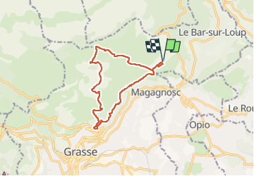
Tocht Stappen van 13,6 km beschikbaar op Provence-Alpes-Côte d'Azur, Alpes-Maritimes, Le Bar-sur-Loup. Deze tocht wordt voorgesteld door domi06.
Beschrijving
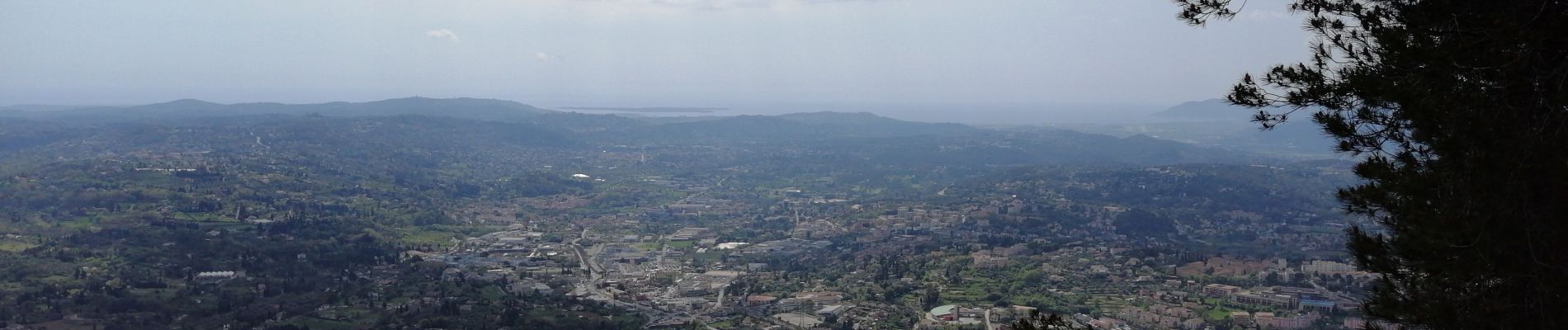
Départ de la Sarrée, le Pilon, prendre le chemin des chasseurs Alpins. Allée des chênes, chemin des Cabres, puis bifurquer à droite derrière une maison pour vous diriger vers une petite sente vous conduisant vers l'aqueduc du Foulon. Prendre une lampe pour passer 3 tunnels. Arrivée à la route Napoleon, direction le bois de la Marbrière. A la B62 quitter le GR pour une belle montée de 1km. Beau point de vue au sommet. A la B63 bifurquer à droite sur la piste de St Christophe jusqu'à la B74, puis retour sur la Sarrée. De très beaux points de vue tout au long de la randonnée
IBP 66 Cotation E3/T3/R3
Plaatsbepaling
Opmerkingen
Wandeltochten in de omgeving
![Tocht Stappen Grasse - petit rando au dessus de Grasse - Photo](https://media.geolcdn.com/t/375/260/ext.jpg?maxdim=2&url=https%3A%2F%2Fservices.sitytrail.com%2FGeolivesWS%2FDownloadMedia.ashx%3FTrailID%3D219692%26Media%3Dfix__20130907100916.jpg)
![Stappen Stappen](https://static1.geolcdn.com/sitytour/trail-icons/101.png)
Stappen
![](/images/other/stat-length.png)
![](https://static1.geolcdn.com/siteimages/upload/files/16400158638029165_repeat_loop_refresh_sync_direction_icon.png)
![Tocht Stappen Gourdon - Plateau de Cavillore, la Forteresse - Gourdon - Photo](https://media.geolcdn.com/t/375/260/ext.jpg?maxdim=2&url=https%3A%2F%2Fservices.sitytrail.com%2FGeolivesWS%2FDownloadMedia.ashx%3FTrailID%3D214895%26Media%3D15446_1.jpg)
![Stappen Stappen](https://static1.geolcdn.com/sitytour/trail-icons/101.png)
Stappen
![](/images/other/stat-length.png)
![](https://static1.geolcdn.com/siteimages/upload/files/16400158638029165_repeat_loop_refresh_sync_direction_icon.png)
![Tocht Stappen Le Bar-sur-Loup - Le Bar sur Loup Gourdon Barre et plateau de Cavillore réel - Photo](https://media.geolcdn.com/t/375/260/c167fd77-8053-444f-a9c7-0c602a316e76.jpg&format=jpg&maxdim=2)
![Stappen Stappen](https://static1.geolcdn.com/sitytour/trail-icons/101.png)
Stappen
![](/images/other/stat-length.png)
![](https://static1.geolcdn.com/siteimages/upload/files/16400158638029165_repeat_loop_refresh_sync_direction_icon.png)
![Tocht Stappen Le Bar-sur-Loup - rando - Photo](https://media.geolcdn.com/t/375/260/fa0ef731-2bd1-40ee-a714-99f05472c6fe.jpg&format=jpg&maxdim=2)
![Stappen Stappen](https://static1.geolcdn.com/sitytour/trail-icons/101.png)
Stappen
![](/images/other/stat-length.png)
![](https://static1.geolcdn.com/siteimages/upload/files/16400158638029165_repeat_loop_refresh_sync_direction_icon.png)
![Tocht Te voet Le Rouret - Le Camp romain - Photo](https://media.geolcdn.com/t/375/260/d6aefa76-dc44-4fc7-8d77-d19148310732.jpeg&format=jpg&maxdim=2)
![Te voet Te voet](https://static1.geolcdn.com/sitytour/trail-icons/100.png)
Te voet
![](/images/other/stat-length.png)
![](https://static1.geolcdn.com/siteimages/upload/files/16400158638029165_repeat_loop_refresh_sync_direction_icon.png)
![Tocht Te voet Le Bar-sur-Loup - Circuit de la Malle - Photo](https://media.geolcdn.com/t/375/260/9cf230aa-9298-45ef-9b30-612a3965bbab.jpeg&format=jpg&maxdim=2)
![Te voet Te voet](https://static1.geolcdn.com/sitytour/trail-icons/100.png)
Te voet
![](/images/other/stat-length.png)
![](https://static1.geolcdn.com/siteimages/upload/files/16400158638029165_repeat_loop_refresh_sync_direction_icon.png)
![Tocht Te voet Le Bar-sur-Loup - Circuit du Paradis - Photo](https://media.geolcdn.com/t/375/260/c599f589-6942-4b9f-bfea-287eb9516c31.jpeg&format=jpg&maxdim=2)
![Te voet Te voet](https://static1.geolcdn.com/sitytour/trail-icons/100.png)
Te voet
![](/images/other/stat-length.png)
![](https://static1.geolcdn.com/siteimages/upload/files/16400158638029165_repeat_loop_refresh_sync_direction_icon.png)
![Tocht Te voet Gourdon - Plateau de Cavillore - Photo](https://media.geolcdn.com/t/375/260/094c0018-0a4d-4f34-8879-15bc82519f15.jpeg&format=jpg&maxdim=2)
![Te voet Te voet](https://static1.geolcdn.com/sitytour/trail-icons/100.png)
Te voet
![](/images/other/stat-length.png)
![](https://static1.geolcdn.com/siteimages/upload/files/16400158638029165_repeat_loop_refresh_sync_direction_icon.png)
![Tocht Te voet Grasse - Tour de la Marbrière - Photo](https://media.geolcdn.com/t/375/260/75605552-a463-425d-8862-67e7b2a12a52.jpeg&format=jpg&maxdim=2)
![Te voet Te voet](https://static1.geolcdn.com/sitytour/trail-icons/100.png)
Te voet
![](/images/other/stat-length.png)
![](https://static1.geolcdn.com/siteimages/upload/files/16400158638029165_repeat_loop_refresh_sync_direction_icon.png)