![](/images/other/stat-length.png)
![Tocht Stappen Sainte-Pazanne - La Beusse - Photo](https://media.geolcdn.com/t/1900/400/0c39b478-ba46-45f5-a403-3503d84dbc03.jpg&format=pjpeg&maxdim=2)
La Beusse
neoroll44
Gebruiker
![Lengte](/images/other/stat-length.png)
![Max. hoogte](https://static1.geolcdn.com/siteimages/upload/files/1508320355ic_sort_altitude_max_24dp.png)
![Positief hoogteverschil](https://static1.geolcdn.com/siteimages/upload/files/1508320355ic_sort_den_pos_24dp.png)
![Km-Effort](/images/other/stat-length.png)
![Min. hoogte](https://static1.geolcdn.com/siteimages/upload/files/1508320355ic_sort_altitude_min_24dp.png)
![Negatief hoogteverschil](https://static1.geolcdn.com/siteimages/upload/files/1508320355ic_sort_den_neg_24dp.png)
![Boucle](https://static1.geolcdn.com/siteimages/upload/files/16400158638029165_repeat_loop_refresh_sync_direction_icon.png)
![Stappen](https://static1.geolcdn.com/sitytour/trail-icons/101.png)
2h00
Moeilijkheid : Gemakkelijk
![Scan deze QR-code om de tocht te openen in de SityTrail-applicatie](https://capi.geolives.com/qq0zvz2zws4bq2lad0pu/sitytour/trails/2735775/qr.png?size=200)
Gratisgps-wandelapplicatie
Over ons
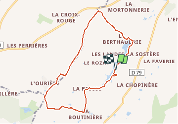
Tocht Stappen van 8,3 km beschikbaar op Pays de la Loire, Loire-Atlantique, Sainte-Pazanne. Deze tocht wordt voorgesteld door neoroll44.
Beschrijving
Découvrez l’étang de la Beusse, aménagé par les agriculteurs pour l’irrigation des cultures ainsi que les villages typiques au cœur du bocage.
Au départ du parking, gagnez l’étang et longez-le par la droite.
Empruntez la passerelle pour passer sur la digue et poursuivez votre
cheminement le long de l’étang.
Passez dans le village de la Bertaudrie puis traversez la route
communale. Continuez tout droit dans le chemin. Au bout de
celui-ci, tournez à gauche avant la route départementale et suivez
le chemin goudronné.
Traversez la route communale, puis continuez tout droit en
empruntant un chemin de terre sur 1.5 km. Tournez à gauche pour
rejoindre la route communale, parcourez-la sur 200 m et bifurquez
à droite le long du petit bois jusqu’au village de la Boutinière.
Tournez à gauche et poursuivez sur la route vers le village de la
Beusse. A l’entrée de celui-ci, prenez à droite et empruntez le chemin
entre les maisons pour rejoindre l’étang. Regagnez le point de départ
en longeant l’étang à droite.
Plaatsbepaling
Opmerkingen
Wandeltochten in de omgeving
![Tocht Te voet Saint-Hilaire-de-Chaléons - Circuit des Templiers - Photo](https://media.geolcdn.com/t/375/260/d2ec675e-afb6-4d2c-b141-de8dacdba4f4.jpeg&format=jpg&maxdim=2)
![Te voet Te voet](https://static1.geolcdn.com/sitytour/trail-icons/100.png)
Te voet
![](/images/other/stat-length.png)
![](https://static1.geolcdn.com/siteimages/upload/files/16400158638029165_repeat_loop_refresh_sync_direction_icon.png)
![Tocht Te voet Villeneuve-en-Retz - Les roseaux et le bocage - Photo](https://media.geolcdn.com/t/375/260/c8f3ca36-d092-4724-80d2-115c2709d19a.jpeg&format=jpg&maxdim=2)
![Te voet Te voet](https://static1.geolcdn.com/sitytour/trail-icons/100.png)
Te voet
![](/images/other/stat-length.png)
![](https://static1.geolcdn.com/siteimages/upload/files/16400158638029165_repeat_loop_refresh_sync_direction_icon.png)
![Tocht Te voet Villeneuve-en-Retz - Les Ajoncs - Photo](https://media.geolcdn.com/t/375/260/a75d8add-319e-469f-abc7-7f7c6664ec76.jpeg&format=jpg&maxdim=2)
![Te voet Te voet](https://static1.geolcdn.com/sitytour/trail-icons/100.png)
Te voet
![](/images/other/stat-length.png)
![](https://static1.geolcdn.com/siteimages/upload/files/16400158638029165_repeat_loop_refresh_sync_direction_icon.png)
![Tocht Stappen Sainte-Pazanne - Ste Pazanne_Coulée_Aqueduc - Photo](https://media.geolcdn.com/t/375/260/ext.jpg?maxdim=2&url=https%3A%2F%2Fservices.sitytrail.com%2FGeolivesWS%2FDownloadMedia.ashx%3FTrailID%3D580011%26Media%3D525ac128-9a89-4ccf-890c-fc7a28420256.jpg)
![Stappen Stappen](https://static1.geolcdn.com/sitytour/trail-icons/101.png)
Stappen
![](/images/other/stat-length.png)
![](https://static1.geolcdn.com/siteimages/upload/files/16400158638029165_repeat_loop_refresh_sync_direction_icon.png)
![Tocht Stappen Sainte-Pazanne - la beusse - Photo](https://media.geolcdn.com/t/375/260/ext.jpg?maxdim=2&url=https%3A%2F%2Fstatic1.geolcdn.com%2Fsiteimages%2Fupload%2Ffiles%2F1553511878bg_sport_marche.png)
![Stappen Stappen](https://static1.geolcdn.com/sitytour/trail-icons/101.png)
Stappen
![](/images/other/stat-length.png)
![](https://static1.geolcdn.com/siteimages/upload/files/16400158638029165_repeat_loop_refresh_sync_direction_icon.png)
![Tocht sport Sainte-Pazanne - 2022-10-18_18h51m43_SityTrail - 2295126 - etang-de-la-beusse - Photo](https://media.geolcdn.com/t/375/260/ext.jpg?maxdim=2&url=https%3A%2F%2Fsecurestorage.geolives.com%2Fsitytour%2Ftrail-bg%2Fdefault.jpg)
sport
![](/images/other/stat-length.png)
![](https://static1.geolcdn.com/siteimages/upload/files/16400158638029165_repeat_loop_refresh_sync_direction_icon.png)
![Tocht Stappen Villeneuve-en-Retz - Villeneuve-en-Retz Randonnée - Photo](https://media.geolcdn.com/t/375/260/ext.jpg?maxdim=2&url=https%3A%2F%2Fstatic1.geolcdn.com%2Fsiteimages%2Fupload%2Ffiles%2F1553511878bg_sport_marche.png)
![Stappen Stappen](https://static1.geolcdn.com/sitytour/trail-icons/101.png)
Stappen
![](/images/other/stat-length.png)
![](https://static1.geolcdn.com/siteimages/upload/files/16400158638029165_repeat_loop_refresh_sync_direction_icon.png)
![Tocht Stappen Sainte-Pazanne - Ste Pazanne - Photo](https://media.geolcdn.com/t/375/260/ext.jpg?maxdim=2&url=https%3A%2F%2Fstatic1.geolcdn.com%2Fsiteimages%2Fupload%2Ffiles%2F1553511878bg_sport_marche.png)
![Stappen Stappen](https://static1.geolcdn.com/sitytour/trail-icons/101.png)
Stappen
![](/images/other/stat-length.png)
![](https://static1.geolcdn.com/siteimages/upload/files/16400158638029165_repeat_loop_refresh_sync_direction_icon.png)