![](/images/other/stat-length.png)
![Tocht Stappen Sallèdes - 2021-04-02_08h47m21_Cirkwi-La_Chaux-Montgros - Photo](https://media.geolcdn.com/t/1900/400/ext.pjpeg?maxdim=2&url=https%3A%2F%2Fstatic1.geolcdn.com%2Fsiteimages%2Fupload%2Ffiles%2F1553511878bg_sport_marche.png)
2021-04-02_08h47m21_Cirkwi-La_Chaux-Montgros
jpcccb
Gebruiker
![Lengte](/images/other/stat-length.png)
![Max. hoogte](https://static1.geolcdn.com/siteimages/upload/files/1508320355ic_sort_altitude_max_24dp.png)
![Positief hoogteverschil](https://static1.geolcdn.com/siteimages/upload/files/1508320355ic_sort_den_pos_24dp.png)
![Km-Effort](/images/other/stat-length.png)
![Min. hoogte](https://static1.geolcdn.com/siteimages/upload/files/1508320355ic_sort_altitude_min_24dp.png)
![Negatief hoogteverschil](https://static1.geolcdn.com/siteimages/upload/files/1508320355ic_sort_den_neg_24dp.png)
![Boucle](https://static1.geolcdn.com/siteimages/upload/files/16400158638029165_repeat_loop_refresh_sync_direction_icon.png)
![Stappen](https://static1.geolcdn.com/sitytour/trail-icons/101.png)
3h29
Moeilijkheid : Moeilijk
![Scan deze QR-code om de tocht te openen in de SityTrail-applicatie](https://capi.geolives.com/qq0zvz2zws4bq2lad0pu/sitytour/trails/2731201/qr.png?size=200)
Gratisgps-wandelapplicatie
Over ons
Tocht Stappen van 10,8 km beschikbaar op Auvergne-Rhône-Alpes, Puy-de-Dôme, Sallèdes. Deze tocht wordt voorgesteld door jpcccb.
Beschrijving
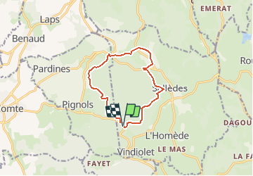
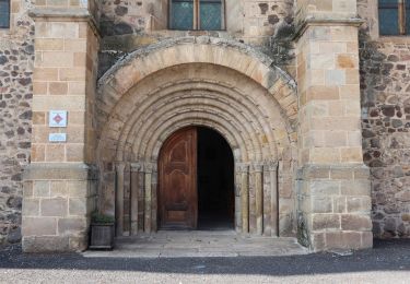
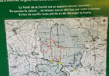
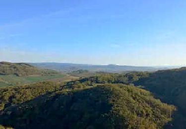
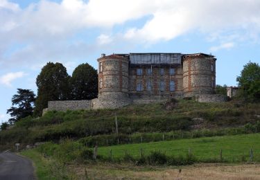
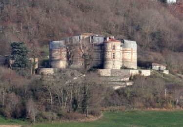
Le château de La Chaux-Montgros est un lieu de mystères qui domine le vaste pays du Comté d'Auvergne. Cette construction Renaissance d’influence italienne du début du XVIe siècle, constitue un monument majeur unique en Auvergne.D. : Prendre le chemin situé entre le panneau de départ et le réservoir. A l’intersection en T, aller à gauche, puis, juste avant la route, partir à droite. A l’intersection en croix, tourner à gauche. Continuer sur le chemin principal jusqu’au croisement avec un large chemin. Le traverser et poursuivre en face jusqu’à une intersection en croix. 1 - Monter à droite jusqu’à une intersection située au pied d’un puy. Descendre à gauche jusqu’à un croisement. Monter à droite. A la fourche, partir à gauche et descendre tout droit jusqu’à un croisement en T quasi à l’orée de la forêt. Partir à droite, monter, passer une intersection et aller jusqu’au croisement suivant (point de vue sur le massif de Sancy, la chaîne des Puys, le plateau de Corent). 2 - Prendre à droite et, tout de suite après, à gauche. Poursuivre dans la forêt en restant sur le chemin principal. A l’intersection, descendre à gauche et, à la fourche, continuer à gauche et rejoindre une route. L’emprunter à droite (point de vue sur le château de Lachaux-Montgros) sur 100 m. Descendre à gauche et, après avoir longé un étang et traversé une route, aller directement jusqu’au château (point de vue sur la Comté, panneau d’information). Descendre la route en contrebas du château. Au carrefour, poursuivre sur la route à gauche sur 250 m et emprunter, à droite, un chemin pour atteindre une route. Continuer tout droit sur celle-ci sur 150 m jusqu’au départ d’un chemin sur la gauche. 3 - Monter à gauche dans la forêt. Après 50 m, aller à gauche et poursuivre jusqu’à une intersection de plusieurs chemins. Prendre à gauche puis, après les premières maisons, descendre à droite pour rejoindre la forêt (point de vue sur Sallèdes).A l’intersection dans la forêt, monter à droite un très large chemin empierré. Au niveau d’un faux plat, tourner à gauche sur un large chemin. Après 50 m, monter à droite, tout droit, jusqu’au sommet du pic des Fleurides (panneaux d’information). Continuer sur le chemin. Après la descente, poursuivre tout droit sur un large chemin. Au niveau d’un replat, monter à gauche. En haut, aller à droite et rejoindre le parking.
Plaatsbepaling
Opmerkingen
Wandeltochten in de omgeving
![Stappen Stappen](https://static1.geolcdn.com/sitytour/trail-icons/101.png)
Stappen
![](/images/other/stat-length.png)
![](https://static1.geolcdn.com/siteimages/upload/files/16400158638029165_repeat_loop_refresh_sync_direction_icon.png)
![Tocht Te voet Manglieu - Le Puy de Ceveloux - Photo](https://media.geolcdn.com/t/375/260/c5127649-bac8-4e49-a988-ae2fa25c3ccb.jpeg&format=jpg&maxdim=2)
![Te voet Te voet](https://static1.geolcdn.com/sitytour/trail-icons/100.png)
Te voet
![](/images/other/stat-length.png)
![](https://static1.geolcdn.com/siteimages/upload/files/16400158638029165_repeat_loop_refresh_sync_direction_icon.png)
![Tocht Te voet Yronde-et-Buron - L'Abbaye du Bouschet - Photo](https://media.geolcdn.com/t/375/260/50cfacdd-f92e-4973-88f2-43faafdab62f.jpeg&format=jpg&maxdim=2)
![Te voet Te voet](https://static1.geolcdn.com/sitytour/trail-icons/100.png)
Te voet
![](/images/other/stat-length.png)
![](https://static1.geolcdn.com/siteimages/upload/files/16400158638029165_repeat_loop_refresh_sync_direction_icon.png)
![Tocht Stappen Sallèdes - bois de la comte - Photo](https://media.geolcdn.com/t/375/260/ext.jpg?maxdim=2&url=https%3A%2F%2Fservices.sitytrail.com%2FGeolivesWS%2FDownloadMedia.ashx%3FTrailID%3D594506%26Media%3Dfix__20160707185207.jpg)
![Stappen Stappen](https://static1.geolcdn.com/sitytour/trail-icons/101.png)
Stappen
![](/images/other/stat-length.png)
![](https://static1.geolcdn.com/siteimages/upload/files/16400158638029165_repeat_loop_refresh_sync_direction_icon.png)
![Tocht Stappen Yronde-et-Buron - Foncrepon_Puy_Moriot - Photo](https://media.geolcdn.com/t/375/260/7a50da42-4be5-4d88-b81e-5c29e8aa1bd9.jpg&format=jpg&maxdim=2)
![Stappen Stappen](https://static1.geolcdn.com/sitytour/trail-icons/101.png)
Stappen
![](/images/other/stat-length.png)
![](https://static1.geolcdn.com/siteimages/upload/files/16400158638029165_repeat_loop_refresh_sync_direction_icon.png)
![Tocht Te voet Pignols - La Chaux-Montgros - Photo](https://media.geolcdn.com/t/375/260/5d646e71-4597-4786-8dcf-db6bbad8285c.jpeg&format=jpg&maxdim=2)
![Te voet Te voet](https://static1.geolcdn.com/sitytour/trail-icons/100.png)
Te voet
![](/images/other/stat-length.png)
![](https://static1.geolcdn.com/siteimages/upload/files/16400158638029165_repeat_loop_refresh_sync_direction_icon.png)
![Tocht Te voet Pignols - Le Bassin de Vic-le-Comte - Photo](https://media.geolcdn.com/t/375/260/86b220b0-6f60-45a4-88a8-78b8e0c44ed5.jpeg&format=jpg&maxdim=2)
![Te voet Te voet](https://static1.geolcdn.com/sitytour/trail-icons/100.png)
Te voet
![](/images/other/stat-length.png)
![](https://static1.geolcdn.com/siteimages/upload/files/16400158638029165_repeat_loop_refresh_sync_direction_icon.png)
![Stappen Stappen](https://static1.geolcdn.com/sitytour/trail-icons/101.png)
Stappen
![](/images/other/stat-length.png)
![](https://static1.geolcdn.com/siteimages/upload/files/16400158638029165_repeat_loop_refresh_sync_direction_icon.png)
![Stappen Stappen](https://static1.geolcdn.com/sitytour/trail-icons/101.png)
Stappen
![](/images/other/stat-length.png)
![](https://static1.geolcdn.com/siteimages/upload/files/16400158638029165_repeat_loop_refresh_sync_direction_icon.png)