![](/images/other/stat-length.png)
![Tocht Stappen Durbuy - Dans le bois de Wéris et de Heyd - Photo](https://media.geolcdn.com/t/1900/400/ext.pjpeg?maxdim=2&url=https%3A%2F%2Fstatic1.geolcdn.com%2Fsiteimages%2Fupload%2Ffiles%2F1553511878bg_sport_marche.png)
Dans le bois de Wéris et de Heyd
pierrebonma
Gebruiker
![Lengte](/images/other/stat-length.png)
Lengte
10,4 km
![Max. hoogte](https://static1.geolcdn.com/siteimages/upload/files/1508320355ic_sort_altitude_max_24dp.png)
Max. hoogte
396 m
![Positief hoogteverschil](https://static1.geolcdn.com/siteimages/upload/files/1508320355ic_sort_den_pos_24dp.png)
Positief hoogteverschil
232 m
![Km-Effort](/images/other/stat-length.png)
Km-Effort
13,5 km
![Min. hoogte](https://static1.geolcdn.com/siteimages/upload/files/1508320355ic_sort_altitude_min_24dp.png)
Min. hoogte
271 m
![Negatief hoogteverschil](https://static1.geolcdn.com/siteimages/upload/files/1508320355ic_sort_den_neg_24dp.png)
Negatief hoogteverschil
234 m
![Boucle](https://static1.geolcdn.com/siteimages/upload/files/16400158638029165_repeat_loop_refresh_sync_direction_icon.png)
Boucle
Ja
Datum van aanmaak :
2021-03-29 04:44:05.817
Laatste wijziging :
2021-03-29 04:57:11.931
![Stappen](https://static1.geolcdn.com/sitytour/trail-icons/101.png)
3h03
Moeilijkheid : Medium
![Scan deze QR-code om de tocht te openen in de SityTrail-applicatie](https://capi.geolives.com/qq0zvz2zws4bq2lad0pu/sitytour/trails/2726164/qr.png?size=200)
Gratisgps-wandelapplicatie
Over ons
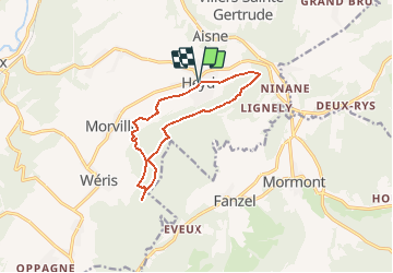
Tocht Stappen van 10,4 km beschikbaar op Wallonië, Luxemburg, Durbuy. Deze tocht wordt voorgesteld door pierrebonma.
Beschrijving
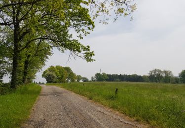
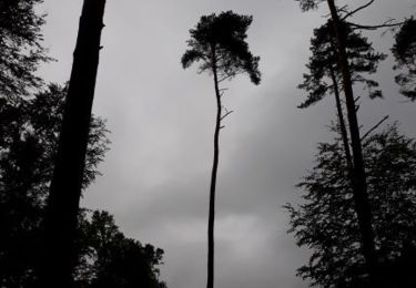
Magnifique promenade fort boisée.
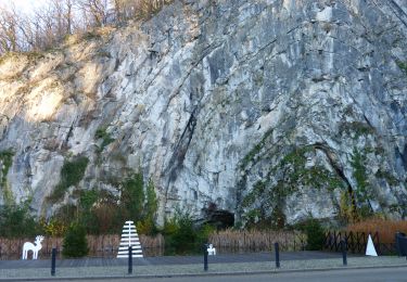
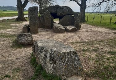
Le lit du diable, la Pierre Heina, le Col du Rideux et le Hé des Pourceaux sont autant de magnifiques lieux à voir.
Un petit banc sympathique permettra de faire un break au Refuge du Brocard
Plaatsbepaling
Land:
Belgium
Regio :
Wallonië
Departement/Provincie :
Luxemburg
Gemeente :
Durbuy
Locatie:
Heyd
Vertrek:(Dec)
Vertrek:(UTM)
682328 ; 5580289 (31U) N.
Opmerkingen
Wandeltochten in de omgeving
![Tocht Stappen Érezée - Hoursinne. Natura 2000, des sites qui valent le détour. Lx 1 - Photo](https://media.geolcdn.com/t/375/260/ext.jpg?maxdim=2&url=https%3A%2F%2Fservices.sitytrail.com%2FGeolivesWS%2FDownloadMedia.ashx%3FTrailID%3D142589%26Media%3Df0338fc2-a78f-45f3-92a6-ccf3ccce12cc.JPG)
![Stappen Stappen](https://static1.geolcdn.com/sitytour/trail-icons/101.png)
Hoursinne. Natura 2000, des sites qui valent le détour. Lx 1
Stappen
Moeilijk
(9)
Érezée,
Wallonië,
Luxemburg,
Belgium
![](/images/other/stat-length.png)
8,1 km | 10,8 km-effort
2h 19min
![](https://static1.geolcdn.com/siteimages/upload/files/16400158638029165_repeat_loop_refresh_sync_direction_icon.png)
Ja
![Tocht Stappen Durbuy - RF-Lu-02 - Variante Ravel - Au fils de l'Ourthe : Barvaux - Photo](https://media.geolcdn.com/t/375/260/ext.jpg?maxdim=2&url=https%3A%2F%2Fstatic1.geolcdn.com%2Fsiteimages%2Fupload%2Ffiles%2F1553511878bg_sport_marche.png)
![Stappen Stappen](https://static1.geolcdn.com/sitytour/trail-icons/101.png)
RF-Lu-02 - Variante Ravel - Au fils de l'Ourthe : Barvaux
Stappen
Heel gemakkelijk
(6)
Durbuy,
Wallonië,
Luxemburg,
Belgium
![](/images/other/stat-length.png)
10,5 km | 13,1 km-effort
2h 45min
![](https://static1.geolcdn.com/siteimages/upload/files/16400158638029165_repeat_loop_refresh_sync_direction_icon.png)
Ja
![Tocht Stappen Durbuy - RF-Lu-01 - De dolmens en menhirs autour de Wéris - Photo](https://media.geolcdn.com/t/375/260/ext.jpg?maxdim=2&url=https%3A%2F%2Fstatic1.geolcdn.com%2Fsiteimages%2Fupload%2Ffiles%2F1553511878bg_sport_marche.png)
![Stappen Stappen](https://static1.geolcdn.com/sitytour/trail-icons/101.png)
RF-Lu-01 - De dolmens en menhirs autour de Wéris
Stappen
Heel gemakkelijk
(7)
Durbuy,
Wallonië,
Luxemburg,
Belgium
![](/images/other/stat-length.png)
12,7 km | 16,5 km-effort
3h 32min
![](https://static1.geolcdn.com/siteimages/upload/files/16400158638029165_repeat_loop_refresh_sync_direction_icon.png)
Ja
![Tocht Stappen Érezée - 2024-10-14_11h35m13_IntincheraEreze - Photo](https://media.geolcdn.com/t/375/260/cc06b86b-a86f-40a6-b741-b1d0842ad353.jpg&format=jpg&maxdim=2)
![Stappen Stappen](https://static1.geolcdn.com/sitytour/trail-icons/101.png)
2024-10-14_11h35m13_IntincheraEreze
Stappen
Medium
(1)
Érezée,
Wallonië,
Luxemburg,
Belgium
![](/images/other/stat-length.png)
10,6 km | 14,5 km-effort
3h 18min
![](https://static1.geolcdn.com/siteimages/upload/files/16400158638029165_repeat_loop_refresh_sync_direction_icon.png)
Ja
![Tocht Stappen Durbuy - Balade à Bomal sur Ourthe - Photo](https://media.geolcdn.com/t/375/260/5741dd62-7ff1-40d2-b9aa-0e0aed97da9a.jpg&format=jpg&maxdim=2)
![Stappen Stappen](https://static1.geolcdn.com/sitytour/trail-icons/101.png)
Balade à Bomal sur Ourthe
Stappen
Gemakkelijk
(4)
Durbuy,
Wallonië,
Luxemburg,
Belgium
![](/images/other/stat-length.png)
4,4 km | 5,9 km-effort
1h 20min
![](https://static1.geolcdn.com/siteimages/upload/files/16400158638029165_repeat_loop_refresh_sync_direction_icon.png)
Ja
![Tocht Stappen Manhay - 2021-06-30_10h29m50_Cirkwi-BOIS_DE_HARRE_(Commune_de_MANHAY) - Photo](https://media.geolcdn.com/t/375/260/c09deda8-fc97-4a3a-abcd-a27b1902d3a9.jpg&format=jpg&maxdim=2)
![Stappen Stappen](https://static1.geolcdn.com/sitytour/trail-icons/101.png)
2021-06-30_10h29m50_Cirkwi-BOIS_DE_HARRE_(Commune_de_MANHAY)
Stappen
Medium
(1)
Manhay,
Wallonië,
Luxemburg,
Belgium
![](/images/other/stat-length.png)
13,5 km | 18,9 km-effort
4h 17min
![](https://static1.geolcdn.com/siteimages/upload/files/16400158638029165_repeat_loop_refresh_sync_direction_icon.png)
Ja
![Stappen Stappen](https://static1.geolcdn.com/sitytour/trail-icons/101.png)
GG2-Lu-36_Bomal-Marloie (2021-11-04)
Stappen
Medium
(2)
Durbuy,
Wallonië,
Luxemburg,
Belgium
![](/images/other/stat-length.png)
43 km | 52 km-effort
11h 51min
![](https://static1.geolcdn.com/siteimages/upload/files/16400158638029165_repeat_loop_refresh_sync_direction_icon.png)
Neen
![Tocht Stappen Durbuy - entre le menhir Pire Hena et le dolmen de Weris ... wouai... - Photo](https://media.geolcdn.com/t/375/260/55715ad5-9df7-48ff-88d3-eb1d3370cd88.jpg&format=jpg&maxdim=2)
![Stappen Stappen](https://static1.geolcdn.com/sitytour/trail-icons/101.png)
entre le menhir Pire Hena et le dolmen de Weris ... wouai...
Stappen
Heel gemakkelijk
(2)
Durbuy,
Wallonië,
Luxemburg,
Belgium
![](/images/other/stat-length.png)
6 km | 7,9 km-effort
2h 0min
![](https://static1.geolcdn.com/siteimages/upload/files/16400158638029165_repeat_loop_refresh_sync_direction_icon.png)
Ja
![Tocht Stappen Durbuy - Deux boucles du Rideux-20kms - Photo](https://media.geolcdn.com/t/375/260/0f5f5c48-cbf4-49e1-bd2e-2bdc08093db1.jpg&format=jpg&maxdim=2)
![Stappen Stappen](https://static1.geolcdn.com/sitytour/trail-icons/101.png)
Deux boucles du Rideux-20kms
Stappen
Zeer moeilijk
(1)
Durbuy,
Wallonië,
Luxemburg,
Belgium
![](/images/other/stat-length.png)
21 km | 28 km-effort
5h 54min
![](https://static1.geolcdn.com/siteimages/upload/files/16400158638029165_repeat_loop_refresh_sync_direction_icon.png)
Ja