![](/images/other/stat-length.png)
![Tocht Stappen La Fare-les-Oliviers - Ste Rosalie - La Fare les Oliviers - Photo](https://media.geolcdn.com/t/1900/400/ext.pjpeg?maxdim=2&url=https%3A%2F%2Fstatic1.geolcdn.com%2Fsiteimages%2Fupload%2Ffiles%2F1553511878bg_sport_marche.png)
Ste Rosalie - La Fare les Oliviers
Regismarseille
Gebruiker
![Lengte](/images/other/stat-length.png)
Lengte
14,1 km
![Max. hoogte](https://static1.geolcdn.com/siteimages/upload/files/1508320355ic_sort_altitude_max_24dp.png)
Max. hoogte
222 m
![Positief hoogteverschil](https://static1.geolcdn.com/siteimages/upload/files/1508320355ic_sort_den_pos_24dp.png)
Positief hoogteverschil
265 m
![Km-Effort](/images/other/stat-length.png)
Km-Effort
17,6 km
![Min. hoogte](https://static1.geolcdn.com/siteimages/upload/files/1508320355ic_sort_altitude_min_24dp.png)
Min. hoogte
89 m
![Negatief hoogteverschil](https://static1.geolcdn.com/siteimages/upload/files/1508320355ic_sort_den_neg_24dp.png)
Negatief hoogteverschil
261 m
![Boucle](https://static1.geolcdn.com/siteimages/upload/files/16400158638029165_repeat_loop_refresh_sync_direction_icon.png)
Boucle
Ja
Datum van aanmaak :
2014-12-10 00:00:00.0
Laatste wijziging :
2014-12-10 00:00:00.0
![Stappen](https://static1.geolcdn.com/sitytour/trail-icons/101.png)
3h39
Moeilijkheid : Gemakkelijk
![Scan deze QR-code om de tocht te openen in de SityTrail-applicatie](https://capi.geolives.com/qq0zvz2zws4bq2lad0pu/sitytour/trails/272516/qr.png?size=200)
Gratisgps-wandelapplicatie
Over ons
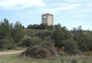
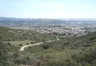
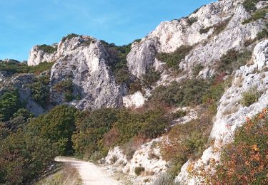
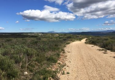
Tocht Stappen van 14,1 km beschikbaar op Provence-Alpes-Côte d'Azur, Bouches-du-Rhône, La Fare-les-Oliviers. Deze tocht wordt voorgesteld door Regismarseille.
Beschrijving
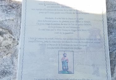
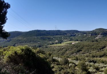
Rando sans trop de dénivelés. Belles vues, jolies couleurs. And a percusive hellucination ;-)
Plaatsbepaling
Land:
France
Regio :
Provence-Alpes-Côte d'Azur
Departement/Provincie :
Bouches-du-Rhône
Gemeente :
La Fare-les-Oliviers
Locatie:
Unknown
Vertrek:(Dec)
Vertrek:(UTM)
677289 ; 4824782 (31T) N.
Opmerkingen
Wandeltochten in de omgeving
![Tocht Stappen Lançon-Provence - muet - Photo](https://media.geolcdn.com/t/375/260/ext.jpg?maxdim=2&url=https%3A%2F%2Fservices.sitytrail.com%2FGeolivesWS%2FDownloadMedia.ashx%3FTrailID%3D1146327%26Media%3Dfix__20190430150458.jpg)
![Stappen Stappen](https://static1.geolcdn.com/sitytour/trail-icons/101.png)
muet
Stappen
Medium
(1)
Lançon-Provence,
Provence-Alpes-Côte d'Azur,
Bouches-du-Rhône,
France
![](/images/other/stat-length.png)
9,9 km | 11,9 km-effort
2h 18min
![](https://static1.geolcdn.com/siteimages/upload/files/16400158638029165_repeat_loop_refresh_sync_direction_icon.png)
Ja
![Stappen Stappen](https://static1.geolcdn.com/sitytour/trail-icons/101.png)
PF-La Fare-les-Oliviers - R - Variante
Stappen
La Fare-les-Oliviers,
Provence-Alpes-Côte d'Azur,
Bouches-du-Rhône,
France
![](/images/other/stat-length.png)
6,6 km | 8,8 km-effort
1h 50min
![](https://static1.geolcdn.com/siteimages/upload/files/16400158638029165_repeat_loop_refresh_sync_direction_icon.png)
Ja
![Stappen Stappen](https://static1.geolcdn.com/sitytour/trail-icons/101.png)
PF-La Fare-les-Oliviers - J
Stappen
Gemakkelijk
La Fare-les-Oliviers,
Provence-Alpes-Côte d'Azur,
Bouches-du-Rhône,
France
![](/images/other/stat-length.png)
9,5 km | 12,1 km-effort
2h 44min
![](https://static1.geolcdn.com/siteimages/upload/files/16400158638029165_repeat_loop_refresh_sync_direction_icon.png)
Ja
![Tocht Stappen La Fare-les-Oliviers - Castelas Bories - Photo](https://media.geolcdn.com/t/375/260/7439faa3-4ac6-4bf5-915a-ec9ef6931431.jpg&format=jpg&maxdim=2)
![Stappen Stappen](https://static1.geolcdn.com/sitytour/trail-icons/101.png)
Castelas Bories
Stappen
Gemakkelijk
La Fare-les-Oliviers,
Provence-Alpes-Côte d'Azur,
Bouches-du-Rhône,
France
![](/images/other/stat-length.png)
10,2 km | 12,9 km-effort
2h 55min
![](https://static1.geolcdn.com/siteimages/upload/files/16400158638029165_repeat_loop_refresh_sync_direction_icon.png)
Neen
![Tocht Stappen La Fare-les-Oliviers - PF-La-Fare-les-Oliviers - J - Variante 3 - Photo](https://media.geolcdn.com/t/375/260/5747beb5-66d2-47a7-a3e4-6503491c48f9.jpg&format=jpg&maxdim=2)
![Stappen Stappen](https://static1.geolcdn.com/sitytour/trail-icons/101.png)
PF-La-Fare-les-Oliviers - J - Variante 3
Stappen
Gemakkelijk
La Fare-les-Oliviers,
Provence-Alpes-Côte d'Azur,
Bouches-du-Rhône,
France
![](/images/other/stat-length.png)
8,9 km | 11,2 km-effort
1h 59min
![](https://static1.geolcdn.com/siteimages/upload/files/16400158638029165_repeat_loop_refresh_sync_direction_icon.png)
Ja
![Tocht Stappen Lançon-Provence - Ruine de Constantine - Chateau Virant - Photo](https://media.geolcdn.com/t/375/260/0b5f7acd-b1d2-4f6a-8303-aa280497c34b.jpg&format=jpg&maxdim=2)
![Stappen Stappen](https://static1.geolcdn.com/sitytour/trail-icons/101.png)
Ruine de Constantine - Chateau Virant
Stappen
Gemakkelijk
Lançon-Provence,
Provence-Alpes-Côte d'Azur,
Bouches-du-Rhône,
France
![](/images/other/stat-length.png)
5,8 km | 8,2 km-effort
2h 15min
![](https://static1.geolcdn.com/siteimages/upload/files/16400158638029165_repeat_loop_refresh_sync_direction_icon.png)
Ja
![Tocht Stappen Lançon-Provence - val muet1 - Photo](https://media.geolcdn.com/t/375/260/abf33d74-bbfa-4a99-864d-db0e20d8035f.jpg&format=jpg&maxdim=2)
![Stappen Stappen](https://static1.geolcdn.com/sitytour/trail-icons/101.png)
val muet1
Stappen
Medium
(4)
Lançon-Provence,
Provence-Alpes-Côte d'Azur,
Bouches-du-Rhône,
France
![](/images/other/stat-length.png)
10 km | 12 km-effort
2h 23min
![](https://static1.geolcdn.com/siteimages/upload/files/16400158638029165_repeat_loop_refresh_sync_direction_icon.png)
Ja
![Tocht Mountainbike Velaux - 2e sortie - Photo](https://media.geolcdn.com/t/375/260/a13a1b21-40a2-45c5-907d-c27a5f73a425.jpg&format=jpg&maxdim=2)
![Mountainbike Mountainbike](https://static1.geolcdn.com/sitytour/trail-icons/202.png)
2e sortie
Mountainbike
Medium
Velaux,
Provence-Alpes-Côte d'Azur,
Bouches-du-Rhône,
France
![](/images/other/stat-length.png)
12,1 km | 14,4 km-effort
2h 11min
![](https://static1.geolcdn.com/siteimages/upload/files/16400158638029165_repeat_loop_refresh_sync_direction_icon.png)
Ja
![Tocht Stappen La Fare-les-Oliviers - PF-La Fare les Oliviers - R - Photo](https://media.geolcdn.com/t/375/260/ext.jpg?maxdim=2&url=https%3A%2F%2Fstatic1.geolcdn.com%2Fsiteimages%2Fupload%2Ffiles%2F1553511878bg_sport_marche.png)
![Stappen Stappen](https://static1.geolcdn.com/sitytour/trail-icons/101.png)
PF-La Fare les Oliviers - R
Stappen
Gemakkelijk
La Fare-les-Oliviers,
Provence-Alpes-Côte d'Azur,
Bouches-du-Rhône,
France
![](/images/other/stat-length.png)
7,2 km | 9,7 km-effort
2h 5min
![](https://static1.geolcdn.com/siteimages/upload/files/16400158638029165_repeat_loop_refresh_sync_direction_icon.png)
Ja