![](/images/other/stat-length.png)
![Tocht Elektrische fiets Aubenas - VAE COL DE SARRAZET - Photo](https://media.geolcdn.com/t/1900/400/ext.pjpeg?maxdim=2&url=https%3A%2F%2Fstatic1.geolcdn.com%2Fsiteimages%2Fupload%2Ffiles%2F1524743154velo.jpg)
VAE COL DE SARRAZET
Mariecoco
Gebruiker
![Lengte](/images/other/stat-length.png)
Lengte
53 km
![Max. hoogte](https://static1.geolcdn.com/siteimages/upload/files/1508320355ic_sort_altitude_max_24dp.png)
Max. hoogte
875 m
![Positief hoogteverschil](https://static1.geolcdn.com/siteimages/upload/files/1508320355ic_sort_den_pos_24dp.png)
Positief hoogteverschil
1289 m
![Km-Effort](/images/other/stat-length.png)
Km-Effort
70 km
![Min. hoogte](https://static1.geolcdn.com/siteimages/upload/files/1508320355ic_sort_altitude_min_24dp.png)
Min. hoogte
193 m
![Negatief hoogteverschil](https://static1.geolcdn.com/siteimages/upload/files/1508320355ic_sort_den_neg_24dp.png)
Negatief hoogteverschil
1287 m
![Boucle](https://static1.geolcdn.com/siteimages/upload/files/16400158638029165_repeat_loop_refresh_sync_direction_icon.png)
Boucle
Ja
Datum van aanmaak :
2021-03-27 09:21:54.44
Laatste wijziging :
2021-03-27 15:09:48.865
![Elektrische fiets](https://static1.geolcdn.com/sitytour/trail-icons/205.png)
5h44
Moeilijkheid : Medium
![Scan deze QR-code om de tocht te openen in de SityTrail-applicatie](https://capi.geolives.com/qq0zvz2zws4bq2lad0pu/sitytour/trails/2723461/qr.png?size=200)
Gratisgps-wandelapplicatie
Over ons
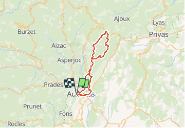
Tocht Elektrische fiets van 53 km beschikbaar op Auvergne-Rhône-Alpes, Ardèche, Aubenas. Deze tocht wordt voorgesteld door Mariecoco.
Beschrijving
VAE Nath
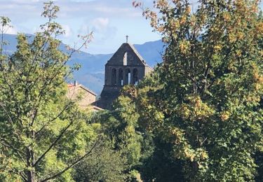
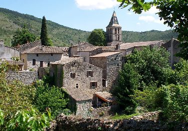
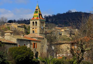
Aubenas, st Julien du Serre ,St Michel et St Étienne de Boulogne ,col de Sarrazet...
52 km 1300 m de dénivelé
Plaatsbepaling
Land:
France
Regio :
Auvergne-Rhône-Alpes
Departement/Provincie :
Ardèche
Gemeente :
Aubenas
Locatie:
Unknown
Vertrek:(Dec)
Vertrek:(UTM)
609440 ; 4941609 (31T) N.
Opmerkingen
Wandeltochten in de omgeving
![Stappen Stappen](https://static1.geolcdn.com/sitytour/trail-icons/101.png)
Trace St Privat autour du Canyon de la Louyre (partie Basse) 19-03-2018
Stappen
Moeilijk
(1)
Saint-Privat,
Auvergne-Rhône-Alpes,
Ardèche,
France
![](/images/other/stat-length.png)
12,1 km | 16,9 km-effort
3h 49min
![](https://static1.geolcdn.com/siteimages/upload/files/16400158638029165_repeat_loop_refresh_sync_direction_icon.png)
Ja
![Tocht Stappen Vals-les-Bains - 07 vals les bains 27.10.2022 - Photo](https://media.geolcdn.com/t/375/260/780fb152-cf3b-4bf0-9468-3f2a5cbe9d03.jpg&format=jpg&maxdim=2)
![Stappen Stappen](https://static1.geolcdn.com/sitytour/trail-icons/101.png)
07 vals les bains 27.10.2022
Stappen
Gemakkelijk
Vals-les-Bains,
Auvergne-Rhône-Alpes,
Ardèche,
France
![](/images/other/stat-length.png)
17,6 km | 29 km-effort
7h 24min
![](https://static1.geolcdn.com/siteimages/upload/files/16400158638029165_repeat_loop_refresh_sync_direction_icon.png)
Ja
![Tocht Stappen Lussas - 07 loutre gorges 09.07.2033 - Photo](https://media.geolcdn.com/t/375/260/b383ddff-373b-408a-8d2a-0f2891f1c4a5.jpg&format=jpg&maxdim=2)
![Stappen Stappen](https://static1.geolcdn.com/sitytour/trail-icons/101.png)
07 loutre gorges 09.07.2033
Stappen
Medium
Lussas,
Auvergne-Rhône-Alpes,
Ardèche,
France
![](/images/other/stat-length.png)
10,8 km | 14,1 km-effort
5h 7min
![](https://static1.geolcdn.com/siteimages/upload/files/16400158638029165_repeat_loop_refresh_sync_direction_icon.png)
Ja
![Stappen Stappen](https://static1.geolcdn.com/sitytour/trail-icons/101.png)
2024-09-25_21h25m23_Ailhon 9km
Stappen
Medium
Ailhon,
Auvergne-Rhône-Alpes,
Ardèche,
France
![](/images/other/stat-length.png)
8,3 km | 11,7 km-effort
2h 39min
![](https://static1.geolcdn.com/siteimages/upload/files/16400158638029165_repeat_loop_refresh_sync_direction_icon.png)
Ja
![Tocht Stappen Vesseaux - 2022-09-25_13h46m35_Vesseaux La Louyre 19km.gpx.xml - Photo](https://media.geolcdn.com/t/375/260/3aabf740-d8d6-4171-abad-fb1ffb7e3d9f.jpg&format=jpg&maxdim=2)
![Stappen Stappen](https://static1.geolcdn.com/sitytour/trail-icons/101.png)
2022-09-25_13h46m35_Vesseaux La Louyre 19km.gpx.xml
Stappen
Moeilijk
Vesseaux,
Auvergne-Rhône-Alpes,
Ardèche,
France
![](/images/other/stat-length.png)
18,3 km | 26 km-effort
6h 0min
![](https://static1.geolcdn.com/siteimages/upload/files/16400158638029165_repeat_loop_refresh_sync_direction_icon.png)
Ja
![Tocht Stappen Vesseaux - 2022-09-25_13h46m12_Vesseaux-St Julien du Serre 15km.gpx (1).xml - Photo](https://media.geolcdn.com/t/375/260/748475d5-a455-4777-a69e-66d579a8c884.jpg&format=jpg&maxdim=2)
![Stappen Stappen](https://static1.geolcdn.com/sitytour/trail-icons/101.png)
2022-09-25_13h46m12_Vesseaux-St Julien du Serre 15km.gpx (1).xml
Stappen
Moeilijk
Vesseaux,
Auvergne-Rhône-Alpes,
Ardèche,
France
![](/images/other/stat-length.png)
15 km | 21 km-effort
4h 49min
![](https://static1.geolcdn.com/siteimages/upload/files/16400158638029165_repeat_loop_refresh_sync_direction_icon.png)
Ja
![Tocht Stappen Lussas - Le canyon de la Louyre - Photo](https://media.geolcdn.com/t/375/260/17cf7f42-deef-45d1-989c-5b99931b061c.jpg&format=jpg&maxdim=2)
![Stappen Stappen](https://static1.geolcdn.com/sitytour/trail-icons/101.png)
Le canyon de la Louyre
Stappen
Moeilijk
Lussas,
Auvergne-Rhône-Alpes,
Ardèche,
France
![](/images/other/stat-length.png)
10,9 km | 14,1 km-effort
4h 25min
![](https://static1.geolcdn.com/siteimages/upload/files/16400158638029165_repeat_loop_refresh_sync_direction_icon.png)
Ja
![Tocht Stappen Vesseaux - Vesseaux 8km - Photo](https://media.geolcdn.com/t/375/260/6eeea0e2-a9f7-4d72-9317-bb3b549f532a.jpg&format=jpg&maxdim=2)
![Stappen Stappen](https://static1.geolcdn.com/sitytour/trail-icons/101.png)
Vesseaux 8km
Stappen
Medium
Vesseaux,
Auvergne-Rhône-Alpes,
Ardèche,
France
![](/images/other/stat-length.png)
7,8 km | 10,3 km-effort
2h 20min
![](https://static1.geolcdn.com/siteimages/upload/files/16400158638029165_repeat_loop_refresh_sync_direction_icon.png)
Ja
![Tocht Stappen Lussas - 07 canyon de la loutre - Photo](https://media.geolcdn.com/t/375/260/8524a072-1d75-4863-9da9-0f55dfad8c49.jpg&format=jpg&maxdim=2)
![Stappen Stappen](https://static1.geolcdn.com/sitytour/trail-icons/101.png)
07 canyon de la loutre
Stappen
Moeilijk
Lussas,
Auvergne-Rhône-Alpes,
Ardèche,
France
![](/images/other/stat-length.png)
14,1 km | 17,2 km-effort
6h 46min
![](https://static1.geolcdn.com/siteimages/upload/files/16400158638029165_repeat_loop_refresh_sync_direction_icon.png)
Ja