![](/images/other/stat-length.png)
![Tocht Stappen Valbonne - 2021-03-27_11h19m10_valbonne-ile-verte-touretttes-loup-et-retour - Photo](https://media.geolcdn.com/t/1900/400/ext.pjpeg?maxdim=2&url=https%3A%2F%2Fstatic1.geolcdn.com%2Fsiteimages%2Fupload%2Ffiles%2F1553511878bg_sport_marche.png)
2021-03-27_11h19m10_valbonne-ile-verte-touretttes-loup-et-retour
domi06
Gebruiker
![Lengte](/images/other/stat-length.png)
Lengte
28 km
![Max. hoogte](https://static1.geolcdn.com/siteimages/upload/files/1508320355ic_sort_altitude_max_24dp.png)
Max. hoogte
380 m
![Positief hoogteverschil](https://static1.geolcdn.com/siteimages/upload/files/1508320355ic_sort_den_pos_24dp.png)
Positief hoogteverschil
944 m
![Km-Effort](/images/other/stat-length.png)
Km-Effort
41 km
![Min. hoogte](https://static1.geolcdn.com/siteimages/upload/files/1508320355ic_sort_altitude_min_24dp.png)
Min. hoogte
42 m
![Negatief hoogteverschil](https://static1.geolcdn.com/siteimages/upload/files/1508320355ic_sort_den_neg_24dp.png)
Negatief hoogteverschil
950 m
![Boucle](https://static1.geolcdn.com/siteimages/upload/files/16400158638029165_repeat_loop_refresh_sync_direction_icon.png)
Boucle
Ja
Datum van aanmaak :
2021-03-27 10:19:15.013
Laatste wijziging :
2021-04-05 16:23:02.738
![Stappen](https://static1.geolcdn.com/sitytour/trail-icons/101.png)
9h18
Moeilijkheid : Gemakkelijk
![Scan deze QR-code om de tocht te openen in de SityTrail-applicatie](https://capi.geolives.com/qq0zvz2zws4bq2lad0pu/sitytour/trails/2722969/qr.png?size=200)
Gratisgps-wandelapplicatie
Over ons
Tocht Stappen van 28 km beschikbaar op Provence-Alpes-Côte d'Azur, Alpes-Maritimes, Valbonne. Deze tocht wordt voorgesteld door domi06.
Beschrijving
Longue randonnée qui débute sur le chemin de Compostelle direction Roquefort Les Pins. Le retour se termine via le parc de Sinodon. Pas de difficulté, mais une bonne endurance est nécessaire.
Plaatsbepaling
Land:
France
Regio :
Provence-Alpes-Côte d'Azur
Departement/Provincie :
Alpes-Maritimes
Gemeente :
Valbonne
Locatie:
Unknown
Vertrek:(Dec)
Vertrek:(UTM)
342732 ; 4834063 (32T) N.
Opmerkingen
Wandeltochten in de omgeving
![Tocht Te voet Le Rouret - Le Camp romain - Photo](https://media.geolcdn.com/t/375/260/d6aefa76-dc44-4fc7-8d77-d19148310732.jpeg&format=jpg&maxdim=2)
![Te voet Te voet](https://static1.geolcdn.com/sitytour/trail-icons/100.png)
Le Camp romain
Te voet
Gemakkelijk
Le Rouret,
Provence-Alpes-Côte d'Azur,
Alpes-Maritimes,
France
![](/images/other/stat-length.png)
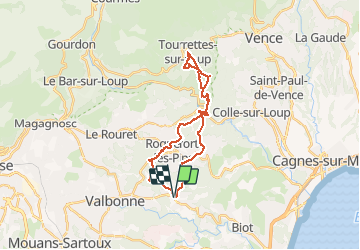
6,8 km | 9,6 km-effort
2h 10min
![](https://static1.geolcdn.com/siteimages/upload/files/16400158638029165_repeat_loop_refresh_sync_direction_icon.png)
Ja
![Tocht Te voet Roquefort-les-Pins - Le Rucher - Photo](https://media.geolcdn.com/t/375/260/8984dec4-46ee-4507-9355-103df05628e2.jpeg&format=jpg&maxdim=2)
![Te voet Te voet](https://static1.geolcdn.com/sitytour/trail-icons/100.png)
Le Rucher
Te voet
Gemakkelijk
Roquefort-les-Pins,
Provence-Alpes-Côte d'Azur,
Alpes-Maritimes,
France
![](/images/other/stat-length.png)
3,7 km | 4,8 km-effort
1h 5min
![](https://static1.geolcdn.com/siteimages/upload/files/16400158638029165_repeat_loop_refresh_sync_direction_icon.png)
Neen
![Tocht Te voet Biot - Sentier de la Vallée de la Brague - Photo](https://media.geolcdn.com/t/375/260/69d5693d-b435-48ea-9803-59cdfb2bd33a.jpeg&format=jpg&maxdim=2)
![Te voet Te voet](https://static1.geolcdn.com/sitytour/trail-icons/100.png)
Sentier de la Vallée de la Brague
Te voet
Gemakkelijk
Biot,
Provence-Alpes-Côte d'Azur,
Alpes-Maritimes,
France
![](/images/other/stat-length.png)
10 km | 12,5 km-effort
2h 50min
![](https://static1.geolcdn.com/siteimages/upload/files/16400158638029165_repeat_loop_refresh_sync_direction_icon.png)
Neen
![Tocht Te voet Valbonne - Circuit des Macarons - Photo](https://media.geolcdn.com/t/375/260/fccba7f8-a613-4c51-ac4f-1073b0b24a76.jpeg&format=jpg&maxdim=2)
![Te voet Te voet](https://static1.geolcdn.com/sitytour/trail-icons/100.png)
Circuit des Macarons
Te voet
Gemakkelijk
Valbonne,
Provence-Alpes-Côte d'Azur,
Alpes-Maritimes,
France
![](/images/other/stat-length.png)
6,3 km | 8,6 km-effort
1h 57min
![](https://static1.geolcdn.com/siteimages/upload/files/16400158638029165_repeat_loop_refresh_sync_direction_icon.png)
Ja
![Tocht Te voet Valbonne - Circuit des Bouillides - Photo](https://media.geolcdn.com/t/375/260/83f1adf9-9b71-481b-afb6-9317825a7553.jpeg&format=jpg&maxdim=2)
![Te voet Te voet](https://static1.geolcdn.com/sitytour/trail-icons/100.png)
Circuit des Bouillides
Te voet
Gemakkelijk
Valbonne,
Provence-Alpes-Côte d'Azur,
Alpes-Maritimes,
France
![](/images/other/stat-length.png)
10,6 km | 13,9 km-effort
3h 8min
![](https://static1.geolcdn.com/siteimages/upload/files/16400158638029165_repeat_loop_refresh_sync_direction_icon.png)
Ja
![Tocht Te voet Valbonne - Circuit du Bruguet - Photo](https://media.geolcdn.com/t/375/260/68fef880-5161-4eed-ba0f-265464725084.jpeg&format=jpg&maxdim=2)
![Te voet Te voet](https://static1.geolcdn.com/sitytour/trail-icons/100.png)
Circuit du Bruguet
Te voet
Gemakkelijk
Valbonne,
Provence-Alpes-Côte d'Azur,
Alpes-Maritimes,
France
![](/images/other/stat-length.png)
7,2 km | 9,4 km-effort
2h 7min
![](https://static1.geolcdn.com/siteimages/upload/files/16400158638029165_repeat_loop_refresh_sync_direction_icon.png)
Ja
![Tocht Te voet Valbonne - Circuit de l'Aqueduc - Photo](https://media.geolcdn.com/t/375/260/98799c39-3904-4577-9867-09b461856d10.jpeg&format=jpg&maxdim=2)
![Te voet Te voet](https://static1.geolcdn.com/sitytour/trail-icons/100.png)
Circuit de l'Aqueduc
Te voet
Gemakkelijk
Valbonne,
Provence-Alpes-Côte d'Azur,
Alpes-Maritimes,
France
![](/images/other/stat-length.png)
6,3 km | 8 km-effort
1h 49min
![](https://static1.geolcdn.com/siteimages/upload/files/16400158638029165_repeat_loop_refresh_sync_direction_icon.png)
Ja
![Tocht Te voet Biot - Circuit de Saint-Philippe - Photo](https://media.geolcdn.com/t/375/260/4ea5c2a5-8352-4835-88c7-4e46e7f4f872.jpeg&format=jpg&maxdim=2)
![Te voet Te voet](https://static1.geolcdn.com/sitytour/trail-icons/100.png)
Circuit de Saint-Philippe
Te voet
Gemakkelijk
Biot,
Provence-Alpes-Côte d'Azur,
Alpes-Maritimes,
France
![](/images/other/stat-length.png)
3,3 km | 4,7 km-effort
1h 4min
![](https://static1.geolcdn.com/siteimages/upload/files/16400158638029165_repeat_loop_refresh_sync_direction_icon.png)
Neen
![Tocht Te voet Biot - Circuit des Pierres à Four - Photo](https://media.geolcdn.com/t/375/260/4ea5c2a5-8352-4835-88c7-4e46e7f4f872.jpeg&format=jpg&maxdim=2)
![Te voet Te voet](https://static1.geolcdn.com/sitytour/trail-icons/100.png)
Circuit des Pierres à Four
Te voet
Gemakkelijk
Biot,
Provence-Alpes-Côte d'Azur,
Alpes-Maritimes,
France
![](/images/other/stat-length.png)
10,3 km | 13 km-effort
2h 57min
![](https://static1.geolcdn.com/siteimages/upload/files/16400158638029165_repeat_loop_refresh_sync_direction_icon.png)
Ja