![](/images/other/stat-length.png)
![Tocht Stappen Aydius - Randonnee-Mardas-Iseye-Mariano-le-20-08-2011 - Photo](https://media.geolcdn.com/t/1900/400/591867db-6d55-44f5-9802-3bb199b71bef.jpg&format=pjpeg&maxdim=2)
Randonnee-Mardas-Iseye-Mariano-le-20-08-2011
neoroll44
Gebruiker
![Lengte](/images/other/stat-length.png)
![Max. hoogte](https://static1.geolcdn.com/siteimages/upload/files/1508320355ic_sort_altitude_max_24dp.png)
![Positief hoogteverschil](https://static1.geolcdn.com/siteimages/upload/files/1508320355ic_sort_den_pos_24dp.png)
![Km-Effort](/images/other/stat-length.png)
![Min. hoogte](https://static1.geolcdn.com/siteimages/upload/files/1508320355ic_sort_altitude_min_24dp.png)
![Negatief hoogteverschil](https://static1.geolcdn.com/siteimages/upload/files/1508320355ic_sort_den_neg_24dp.png)
![Boucle](https://static1.geolcdn.com/siteimages/upload/files/16400158638029165_repeat_loop_refresh_sync_direction_icon.png)
![Stappen](https://static1.geolcdn.com/sitytour/trail-icons/101.png)
5h30
Moeilijkheid : Moeilijk
![Scan deze QR-code om de tocht te openen in de SityTrail-applicatie](https://capi.geolives.com/qq0zvz2zws4bq2lad0pu/sitytour/trails/2721049/qr.png?size=200)
Gratisgps-wandelapplicatie
Over ons
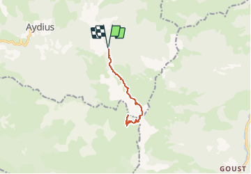
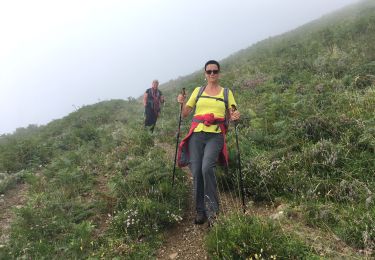
Tocht Stappen van 10,3 km beschikbaar op Nieuw-Aquitanië, Pyrénées-Atlantiques, Aydius. Deze tocht wordt voorgesteld door neoroll44.
Beschrijving
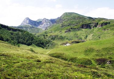
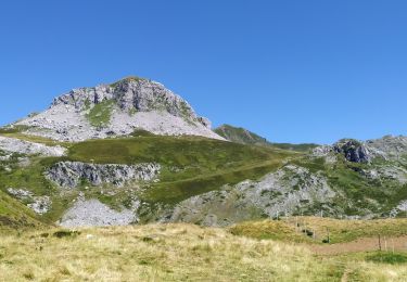
Depuis le village d’Aydius suivre la piste pendant 6,5km , les 3 derniers kilomètres se font sur une piste carrossable en bon état. Altitude 1060m, un cairn au bord de la piste vous indique le départ de la randonnée. Suivre le sentier rentrant dans le bois (plein Sud)
Attention: La piste qui était autorisée ces dernières années est de nouveau soumise à une réglementation: l’accès au parking final en voiture, après la piste carrossable, est autorisé seulement avant 9h du matin, l’amende de 5ème classe peut aller jusqu’à 1500€ ! ! ! dans le doute renseignez-vous à la mairie.
Plaatsbepaling
Opmerkingen
Wandeltochten in de omgeving
![Tocht Stappen Bielle - Pics de Cambeilh et petit Gerbe - Photo](https://media.geolcdn.com/t/375/260/ext.jpg?maxdim=2&url=https%3A%2F%2Fservices.sitytrail.com%2FGeolivesWS%2FDownloadMedia.ashx%3FTrailID%3D521181%26Media%3Dfix__20160202151847.jpg)
![Stappen Stappen](https://static1.geolcdn.com/sitytour/trail-icons/101.png)
Stappen
![](/images/other/stat-length.png)
![](https://static1.geolcdn.com/siteimages/upload/files/16400158638029165_repeat_loop_refresh_sync_direction_icon.png)
![Tocht Te voet Aydius - Tour du Mailh Massibé par Bésur asp100 - Photo](https://media.geolcdn.com/t/375/260/63a6bafa-5459-4dce-bf36-a3e4ba983890.jpeg&format=jpg&maxdim=2)
![Te voet Te voet](https://static1.geolcdn.com/sitytour/trail-icons/100.png)
Te voet
![](/images/other/stat-length.png)
![](https://static1.geolcdn.com/siteimages/upload/files/16400158638029165_repeat_loop_refresh_sync_direction_icon.png)
![Tocht Te voet Aydius - Chemin des Buis de Camploung asp22 - Photo](https://media.geolcdn.com/t/375/260/63a6bafa-5459-4dce-bf36-a3e4ba983890.jpeg&format=jpg&maxdim=2)
![Te voet Te voet](https://static1.geolcdn.com/sitytour/trail-icons/100.png)
Te voet
![](/images/other/stat-length.png)
![](https://static1.geolcdn.com/siteimages/upload/files/16400158638029165_repeat_loop_refresh_sync_direction_icon.png)
![Tocht Te voet Aydius - Col de Bergout par les Ichantes asp23 - Photo](https://media.geolcdn.com/t/375/260/63a6bafa-5459-4dce-bf36-a3e4ba983890.jpeg&format=jpg&maxdim=2)
![Te voet Te voet](https://static1.geolcdn.com/sitytour/trail-icons/100.png)
Te voet
![](/images/other/stat-length.png)
![](https://static1.geolcdn.com/siteimages/upload/files/16400158638029165_repeat_loop_refresh_sync_direction_icon.png)
![Tocht Stappen Aydius - lac de montagnon - Photo](https://media.geolcdn.com/t/375/260/5ed19e71-65a9-444b-82ea-9100b101a800.jpg&format=jpg&maxdim=2)
![Stappen Stappen](https://static1.geolcdn.com/sitytour/trail-icons/101.png)
Stappen
![](/images/other/stat-length.png)
![](https://static1.geolcdn.com/siteimages/upload/files/16400158638029165_repeat_loop_refresh_sync_direction_icon.png)
![Tocht Te voet Aydius - du Barca à la Cabane d'Arriutort asp106 - Photo](https://media.geolcdn.com/t/375/260/df582091-8896-406d-a764-75869922f6a5.jpeg&format=jpg&maxdim=2)
![Te voet Te voet](https://static1.geolcdn.com/sitytour/trail-icons/100.png)
Te voet
![](/images/other/stat-length.png)
![](https://static1.geolcdn.com/siteimages/upload/files/16400158638029165_repeat_loop_refresh_sync_direction_icon.png)
![Tocht Stappen Aydius - 021 Tour_Igaut-Chechit ab - Photo](https://media.geolcdn.com/t/375/260/4dff1440-f8d2-42a9-984d-2668c1d2f04d.jpg&format=jpg&maxdim=2)
![Stappen Stappen](https://static1.geolcdn.com/sitytour/trail-icons/101.png)
Stappen
![](/images/other/stat-length.png)
![](https://static1.geolcdn.com/siteimages/upload/files/16400158638029165_repeat_loop_refresh_sync_direction_icon.png)
![Tocht Stappen Accous - Cabane du Bergout - Photo](https://media.geolcdn.com/t/375/260/d517029d-cf6a-4526-aeb7-ac8002b292f1.jpg&format=jpg&maxdim=2)
![Stappen Stappen](https://static1.geolcdn.com/sitytour/trail-icons/101.png)
Stappen
![](/images/other/stat-length.png)
![](https://static1.geolcdn.com/siteimages/upload/files/16400158638029165_repeat_loop_refresh_sync_direction_icon.png)
![Tocht Stappen Aydius - pic mailh massibe et pic montagnon - Photo](https://media.geolcdn.com/t/375/260/12402e24-34c8-4e69-b3a6-ad60fc7c5ccb.jpg&format=jpg&maxdim=2)
![Stappen Stappen](https://static1.geolcdn.com/sitytour/trail-icons/101.png)
Stappen
![](/images/other/stat-length.png)
![](https://static1.geolcdn.com/siteimages/upload/files/16400158638029165_repeat_loop_refresh_sync_direction_icon.png)