![](/images/other/stat-length.png)
![Tocht Stappen Saint-Germain-en-Coglès - Gr 34 étape 4 - Photo](https://media.geolcdn.com/t/1900/400/ext.pjpeg?maxdim=2&url=https%3A%2F%2Fservices.sitytrail.com%2FGeolivesWS%2FDownloadMedia.ashx%3FTrailID%3D271009%26Media%3Dfix__20140410160428.jpg)
Gr 34 étape 4
lagardienne
Gebruiker
![Lengte](/images/other/stat-length.png)
Lengte
38 km
![Max. hoogte](https://static1.geolcdn.com/siteimages/upload/files/1508320355ic_sort_altitude_max_24dp.png)
Max. hoogte
185 m
![Positief hoogteverschil](https://static1.geolcdn.com/siteimages/upload/files/1508320355ic_sort_den_pos_24dp.png)
Positief hoogteverschil
438 m
![Km-Effort](/images/other/stat-length.png)
Km-Effort
44 km
![Min. hoogte](https://static1.geolcdn.com/siteimages/upload/files/1508320355ic_sort_altitude_min_24dp.png)
Min. hoogte
11 m
![Negatief hoogteverschil](https://static1.geolcdn.com/siteimages/upload/files/1508320355ic_sort_den_neg_24dp.png)
Negatief hoogteverschil
572 m
![Boucle](https://static1.geolcdn.com/siteimages/upload/files/16400158638029165_repeat_loop_refresh_sync_direction_icon.png)
Boucle
Neen
Datum van aanmaak :
2014-12-10 00:00:00.0
Laatste wijziging :
2014-12-10 00:00:00.0
![Stappen](https://static1.geolcdn.com/sitytour/trail-icons/101.png)
9h31
Moeilijkheid : Medium
![Scan deze QR-code om de tocht te openen in de SityTrail-applicatie](https://capi.geolives.com/qq0zvz2zws4bq2lad0pu/sitytour/trails/271009/qr.png?size=200)
Gratisgps-wandelapplicatie
Over ons
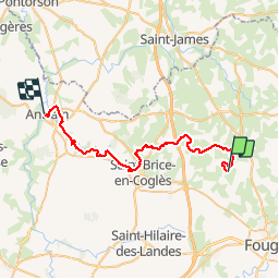
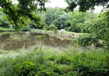
Tocht Stappen van 38 km beschikbaar op Bretagne, Ille-et-Vilaine, Saint-Germain-en-Coglès. Deze tocht wordt voorgesteld door lagardienne.
Beschrijving
Bientôt sur le jardindelolo.fr le récit de mon périple sur le GR 34, étape par étape avec commentaires et photos.
Plaatsbepaling
Land:
France
Regio :
Bretagne
Departement/Provincie :
Ille-et-Vilaine
Gemeente :
Saint-Germain-en-Coglès
Locatie:
Unknown
Vertrek:(Dec)
Vertrek:(UTM)
629038 ; 5363533 (30U) N.
Opmerkingen
Wandeltochten in de omgeving
![Tocht Te voet Le Châtellier - Le Chatellier - le cirque du Diable - Photo](https://media.geolcdn.com/t/375/260/5ed848be-956b-4ee2-b198-d6e89ae86cbe.jpeg&format=jpg&maxdim=2)
![Te voet Te voet](https://static1.geolcdn.com/sitytour/trail-icons/100.png)
Le Chatellier - le cirque du Diable
Te voet
Gemakkelijk
Le Châtellier,
Bretagne,
Ille-et-Vilaine,
France
![](/images/other/stat-length.png)
5,9 km | 7,1 km-effort
1h 37min
![](https://static1.geolcdn.com/siteimages/upload/files/16400158638029165_repeat_loop_refresh_sync_direction_icon.png)
Ja
![Tocht Noords wandelen Landéan - Poulailler autour du Moulin d'Avion 12,5km - Photo](https://media.geolcdn.com/t/375/260/ext.jpg?maxdim=2&url=https%3A%2F%2Fservices.sitytrail.com%2FGeolivesWS%2FDownloadMedia.ashx%3FTrailID%3D676451%26Media%3Dcc3eee66-6e8e-4acd-8735-e9a30f06fcf1.jpeg)
![Noords wandelen Noords wandelen](https://static1.geolcdn.com/sitytour/trail-icons/102.png)
Poulailler autour du Moulin d'Avion 12,5km
Noords wandelen
Medium
Landéan,
Bretagne,
Ille-et-Vilaine,
France
![](/images/other/stat-length.png)
12,5 km | 14,9 km-effort
2h 10min
![](https://static1.geolcdn.com/siteimages/upload/files/16400158638029165_repeat_loop_refresh_sync_direction_icon.png)
Ja
![Tocht Noords wandelen Landéan - Poulailler Chénedet 10,4km - Photo](https://media.geolcdn.com/t/375/260/ext.jpg?maxdim=2&url=https%3A%2F%2Fservices.sitytrail.com%2FGeolivesWS%2FDownloadMedia.ashx%3FTrailID%3D676433%26Media%3Dc418e412-7874-4576-9726-02eef27b2c32.jpg)
![Noords wandelen Noords wandelen](https://static1.geolcdn.com/sitytour/trail-icons/102.png)
Poulailler Chénedet 10,4km
Noords wandelen
Medium
Landéan,
Bretagne,
Ille-et-Vilaine,
France
![](/images/other/stat-length.png)
10,3 km | 12,5 km-effort
2h 50min
![](https://static1.geolcdn.com/siteimages/upload/files/16400158638029165_repeat_loop_refresh_sync_direction_icon.png)
Ja
![Tocht Noords wandelen Landéan - CMN Du Poulailler dans la ville 15 km - Photo](https://media.geolcdn.com/t/375/260/ext.jpg?maxdim=2&url=https%3A%2F%2Fservices.sitytrail.com%2FGeolivesWS%2FDownloadMedia.ashx%3FTrailID%3D162112%26Media%3D9e9344dd-ab74-44da-9479-e497c8838235.jpeg)
![Noords wandelen Noords wandelen](https://static1.geolcdn.com/sitytour/trail-icons/102.png)
CMN Du Poulailler dans la ville 15 km
Noords wandelen
Medium
Landéan,
Bretagne,
Ille-et-Vilaine,
France
![](/images/other/stat-length.png)
14,9 km | 18 km-effort
2h 50min
![](https://static1.geolcdn.com/siteimages/upload/files/16400158638029165_repeat_loop_refresh_sync_direction_icon.png)
Ja
![Tocht Noords wandelen Landéan - Poulailler à Galoupel 11,6km - Photo](https://media.geolcdn.com/t/375/260/ext.jpg?maxdim=2&url=https%3A%2F%2Fservices.sitytrail.com%2FGeolivesWS%2FDownloadMedia.ashx%3FTrailID%3D162110%26Media%3D413a32e4-2e2a-44c9-a005-215b3d70b193.jpg)
![Noords wandelen Noords wandelen](https://static1.geolcdn.com/sitytour/trail-icons/102.png)
Poulailler à Galoupel 11,6km
Noords wandelen
Medium
Landéan,
Bretagne,
Ille-et-Vilaine,
France
![](/images/other/stat-length.png)
11,5 km | 13,9 km-effort
2h 10min
![](https://static1.geolcdn.com/siteimages/upload/files/16400158638029165_repeat_loop_refresh_sync_direction_icon.png)
Ja
![Tocht Noords wandelen Landéan - CMN Du Poulailler à Galoupel 10 km - Photo](https://media.geolcdn.com/t/375/260/ext.jpg?maxdim=2&url=https%3A%2F%2Fservices.sitytrail.com%2FGeolivesWS%2FDownloadMedia.ashx%3FTrailID%3D161980%26Media%3D800e4604-8306-4691-91cf-47312969d59f.jpeg)
![Noords wandelen Noords wandelen](https://static1.geolcdn.com/sitytour/trail-icons/102.png)
CMN Du Poulailler à Galoupel 10 km
Noords wandelen
Medium
Landéan,
Bretagne,
Ille-et-Vilaine,
France
![](/images/other/stat-length.png)
10,2 km | 12,3 km-effort
1h 40min
![](https://static1.geolcdn.com/siteimages/upload/files/16400158638029165_repeat_loop_refresh_sync_direction_icon.png)
Ja
![Tocht Stappen Le Châtellier - GR_37_AE_19_Chatellier_Fougeres_20210618 - Photo](https://media.geolcdn.com/t/375/260/86e0ada0-a5bb-4e42-a786-1c56487d1d50.jpg&format=jpg&maxdim=2)
![Stappen Stappen](https://static1.geolcdn.com/sitytour/trail-icons/101.png)
GR_37_AE_19_Chatellier_Fougeres_20210618
Stappen
Gemakkelijk
Le Châtellier,
Bretagne,
Ille-et-Vilaine,
France
![](/images/other/stat-length.png)
19 km | 23 km-effort
4h 58min
![](https://static1.geolcdn.com/siteimages/upload/files/16400158638029165_repeat_loop_refresh_sync_direction_icon.png)
Neen
![Tocht Noords wandelen Les Portes du Coglais - montours pontbesnard chênesec11km - Photo](https://media.geolcdn.com/t/375/260/ext.jpg?maxdim=2&url=https%3A%2F%2Fstatic1.geolcdn.com%2Fsiteimages%2Fupload%2Ffiles%2F1545311037marcheuse_200dpi.jpg)
![Noords wandelen Noords wandelen](https://static1.geolcdn.com/sitytour/trail-icons/102.png)
montours pontbesnard chênesec11km
Noords wandelen
Medium
(1)
Les Portes du Coglais,
Bretagne,
Ille-et-Vilaine,
France
![](/images/other/stat-length.png)
11,3 km | 13,1 km-effort
2h 30min
![](https://static1.geolcdn.com/siteimages/upload/files/16400158638029165_repeat_loop_refresh_sync_direction_icon.png)
Ja
![Tocht Noords wandelen Les Portes du Coglais - Montours talvassais 7,5km - Photo](https://media.geolcdn.com/t/375/260/ext.jpg?maxdim=2&url=https%3A%2F%2Fstatic1.geolcdn.com%2Fsiteimages%2Fupload%2Ffiles%2F1545311037marcheuse_200dpi.jpg)
![Noords wandelen Noords wandelen](https://static1.geolcdn.com/sitytour/trail-icons/102.png)
Montours talvassais 7,5km
Noords wandelen
Medium
(1)
Les Portes du Coglais,
Bretagne,
Ille-et-Vilaine,
France
![](/images/other/stat-length.png)
7,6 km | 8,8 km-effort
2h 0min
![](https://static1.geolcdn.com/siteimages/upload/files/16400158638029165_repeat_loop_refresh_sync_direction_icon.png)
Ja