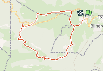
![](/images/other/stat-length.png)
![Tocht Te voet Bilhères - La Cabane de Lasbordes - G2 - Photo](https://media.geolcdn.com/t/1900/400/ext.pjpeg?maxdim=2&url=https%3A%2F%2Fstatic1.geolcdn.com%2Fsiteimages%2Fupload%2Ffiles%2F1545311037marcheuse_200dpi.jpg)
La Cabane de Lasbordes - G2
mitch1952
Gebruiker
![Lengte](/images/other/stat-length.png)
![Max. hoogte](https://static1.geolcdn.com/siteimages/upload/files/1508320355ic_sort_altitude_max_24dp.png)
![Positief hoogteverschil](https://static1.geolcdn.com/siteimages/upload/files/1508320355ic_sort_den_pos_24dp.png)
![Km-Effort](/images/other/stat-length.png)
![Min. hoogte](https://static1.geolcdn.com/siteimages/upload/files/1508320355ic_sort_altitude_min_24dp.png)
![Negatief hoogteverschil](https://static1.geolcdn.com/siteimages/upload/files/1508320355ic_sort_den_neg_24dp.png)
![Boucle](https://static1.geolcdn.com/siteimages/upload/files/16400158638029165_repeat_loop_refresh_sync_direction_icon.png)
![Te voet](https://static1.geolcdn.com/sitytour/trail-icons/100.png)
4h41
Moeilijkheid : Medium
![Scan deze QR-code om de tocht te openen in de SityTrail-applicatie](https://capi.geolives.com/qq0zvz2zws4bq2lad0pu/sitytour/trails/2704056/qr.png?size=200)
Gratisgps-wandelapplicatie
Over ons
Tocht Te voet van 11,9 km beschikbaar op Nieuw-Aquitanië, Pyrénées-Atlantiques, Bilhères. Deze tocht wordt voorgesteld door mitch1952.
Beschrijving
Ce circuit (D 625m) vous emmène sur les pentes du versant sud du BENOU. En prenant de la hauteur , c'est aussi une autre dimension qui se présente à vous: un décor sauvage et des points de vue panoramiques à près de 1500m d'altitude (Rocher d'ARAN, Massif de LAZERGUE, Montagne du REY, Massif de JAUT,...). N'oubliez pas votre appareil photo! Après la cabane d LASBORDES, typique cujala montagnard, la descente sur le BENOU est douce et ombragée.
Plaatsbepaling
Opmerkingen
Wandeltochten in de omgeving
![Tocht Stappen Louvie-Juzon - Soum de las Picarras Montagne du Rey - Photo](https://media.geolcdn.com/t/375/260/ext.jpg?maxdim=2&url=https%3A%2F%2Fservices.sitytrail.com%2FGeolivesWS%2FDownloadMedia.ashx%3FTrailID%3D541294%26Media%3Dfix__20160320134039.jpg)
![Stappen Stappen](https://static1.geolcdn.com/sitytour/trail-icons/101.png)
Stappen
![](/images/other/stat-length.png)
![](https://static1.geolcdn.com/siteimages/upload/files/16400158638029165_repeat_loop_refresh_sync_direction_icon.png)
![Tocht Stappen Bielle - Pics de Cambeilh et petit Gerbe - Photo](https://media.geolcdn.com/t/375/260/ext.jpg?maxdim=2&url=https%3A%2F%2Fservices.sitytrail.com%2FGeolivesWS%2FDownloadMedia.ashx%3FTrailID%3D521181%26Media%3Dfix__20160202151847.jpg)
![Stappen Stappen](https://static1.geolcdn.com/sitytour/trail-icons/101.png)
Stappen
![](/images/other/stat-length.png)
![](https://static1.geolcdn.com/siteimages/upload/files/16400158638029165_repeat_loop_refresh_sync_direction_icon.png)
![Tocht Stappen Bielle - BIELLE l arriu Mage reco 3443541 - Photo](https://media.geolcdn.com/t/375/260/85ef7966-54fd-44d2-aeee-6b5bc4ac7165.jpg&format=jpg&maxdim=2)
![Stappen Stappen](https://static1.geolcdn.com/sitytour/trail-icons/101.png)
Stappen
![](/images/other/stat-length.png)
![](https://static1.geolcdn.com/siteimages/upload/files/16400158638029165_repeat_loop_refresh_sync_direction_icon.png)
![Tocht Te voet Gère-Bélesten - La fontaine d'Esteret - Photo](https://media.geolcdn.com/t/375/260/d66768f9-56af-43eb-9e0f-c5096acb8e4f.jpeg&format=jpg&maxdim=2)
![Te voet Te voet](https://static1.geolcdn.com/sitytour/trail-icons/100.png)
Te voet
![](/images/other/stat-length.png)
![](https://static1.geolcdn.com/siteimages/upload/files/16400158638029165_repeat_loop_refresh_sync_direction_icon.png)
![Tocht Te voet Bielle - L'Arriu-Mage - Photo](https://media.geolcdn.com/t/375/260/9d640f1d-cca3-4d6c-b124-0b8f06a68e5a.jpeg&format=jpg&maxdim=2)
![Te voet Te voet](https://static1.geolcdn.com/sitytour/trail-icons/100.png)
Te voet
![](/images/other/stat-length.png)
![](https://static1.geolcdn.com/siteimages/upload/files/16400158638029165_repeat_loop_refresh_sync_direction_icon.png)
![Tocht Te voet Bilhères - Les cercles de pierre (Bilhères) - Photo](https://media.geolcdn.com/t/375/260/d1f3f786-1fe8-47a8-af2d-8ff90104ea03.jpeg&format=jpg&maxdim=2)
![Te voet Te voet](https://static1.geolcdn.com/sitytour/trail-icons/100.png)
Te voet
![](/images/other/stat-length.png)
![](https://static1.geolcdn.com/siteimages/upload/files/16400158638029165_repeat_loop_refresh_sync_direction_icon.png)
![Tocht Te voet Bilhères - Les cabanes de Lasbordes - Photo](https://media.geolcdn.com/t/375/260/6d402dc4-6faf-449a-b98e-9a6932ddd2f6.jpeg&format=jpg&maxdim=2)
![Te voet Te voet](https://static1.geolcdn.com/sitytour/trail-icons/100.png)
Te voet
![](/images/other/stat-length.png)
![](https://static1.geolcdn.com/siteimages/upload/files/16400158638029165_repeat_loop_refresh_sync_direction_icon.png)
![Tocht Te voet Louvie-Juzon - Le piémont du Rey - Photo](https://media.geolcdn.com/t/375/260/f491a556-8ecd-4525-a2fc-b2b6d591e533.jpeg&format=jpg&maxdim=2)
![Te voet Te voet](https://static1.geolcdn.com/sitytour/trail-icons/100.png)
Te voet
![](/images/other/stat-length.png)
![](https://static1.geolcdn.com/siteimages/upload/files/16400158638029165_repeat_loop_refresh_sync_direction_icon.png)
![Tocht Te voet Arudy - Le tour du bassin d'Arudy - Photo](https://media.geolcdn.com/t/375/260/f77d5769-a1f2-499c-9920-96e8d227d4fb.jpeg&format=jpg&maxdim=2)
![Te voet Te voet](https://static1.geolcdn.com/sitytour/trail-icons/100.png)
Te voet
![](/images/other/stat-length.png)
![](https://static1.geolcdn.com/siteimages/upload/files/16400158638029165_repeat_loop_refresh_sync_direction_icon.png)