Tocht Mountainbike Virton - Signeulx I  -  Balade_VTT_27kms - Photo

Signeulx I - Balade_VTT_27kms

 Pascal L
Pascal L

Gebruiker

© OpenStreetMap contributors
Lengte
Lengte
27 km
Max. hoogte
Max. hoogte
301 m
Positief hoogteverschil
360 m
Km-Effort
Km-Effort  
31 km
Min. hoogte
Min. hoogte
205 m
Negatief hoogteverschil
361 m
Boucle
Boucle
Ja
Datum van aanmaak :
2021-03-07 15:39:43.081
Laatste wijziging :
2022-08-17 12:32:15.046

(0 Bericht)

Mountainbike
Mountainbike
2h44
Moeilijkheid : Heel gemakkelijk

Scan deze QR-code om de tocht te openen in de SityTrail-applicatie

Gratisgps-wandelapplicatie

Logo SityTrail SityTrail

IGN / Geografische instituten

SityTrail uit de App Store downloaden SityTrail uit Google Play downloaden

Logo SityTrail SityTrail World

De wereld gaat voor u open

SityTrail uit de App Store downloaden SityTrail uit Google Play downloaden SityTrail op Huawei AppGallery downloaden

Over ons

Tocht Mountainbike van 27 km beschikbaar op Wallonië, Luxemburg, Virton. Deze tocht wordt voorgesteld door Pascal L.

Beschrijving

Départ/Retour: Virton (Pierrard)

Endroits de passage: Pierrard, Chenois, Ravel, Etangs de Latour, ZI de Latour, Ruette, Bouemont, Saint-Rémy, Signeulx,  Bleid, Gévimont, Ethe, Ravel (ligne 155)

Ref.
- https://www.musson.be/loisirs/tourisme/salles/a-signeulx

(2021.03.07)

Hoogteprofiel

Foto's

POI's

POI Virton - Les étangs de Latour - Photo
Pascal L
POI Saint-Pancré - Parcs éoliens des Deux Rivières (France) - Photo
Pascal L
POI Virton - Camping la Colline - Photo
Pascal L
POI Virton - Golf Découverte Virton - Photo
Pascal L

Plaatsbepaling

Land:
Belgium
Regio :
Wallonië
Departement/Provincie :
Luxemburg
Gemeente :
Virton
Locatie:
Virton
Vertrek:(UTM)
684210 ; 5494462 (31U) N.

Wandeltochten in de omgeving

Tocht Stappen Virton - RB-Lu-17_Ethe_via-var-1-et-2-et-3 - Photo
Stappen
PRO

Stappen

Heel gemakkelijk
(3)
Virton, Wallonië, Luxemburg, Belgium
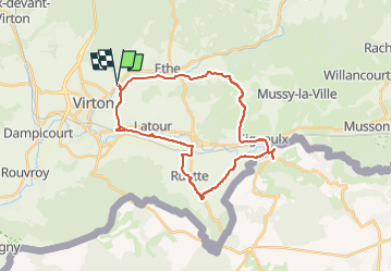
29 km | 35 km-effort
7h 33min
Ja
Tocht Mountainbike Virton - T2019-06-16-16-47 - Photo
Mountainbike
Pascal L

Mountainbike

Gemakkelijk
(1)
Virton, Wallonië, Luxemburg, Belgium
21 km | 26 km-effort
1h 40min
Ja
Tocht Stappen Virton - GAUME Balade  naturelle et historique - Photo
Stappen
julucasi

Stappen

Heel gemakkelijk
(1)
Virton, Wallonië, Luxemburg, Belgium
5,2 km | 6,8 km-effort
1h 16min
Ja
Tocht Te voet Virton - La Bajocienne - Photo
Te voet
GUIDE+

Te voet

Gemakkelijk
(1)
Virton, Wallonië, Luxemburg, Belgium
11 km | 14,5 km-effort
3h 17min
Ja
Tocht Stappen Virton - RB-Lu-17_Ethe_via-racc - Photo
Stappen
PRO

Stappen

Heel gemakkelijk
Virton, Wallonië, Luxemburg, Belgium
15,6 km | 19,3 km-effort
4h 8min
Ja
Tocht Stappen Virton - RB-Lu-17_Ethe - Photo
Stappen
PRO

Stappen

Heel gemakkelijk
Virton, Wallonië, Luxemburg, Belgium
22 km | 28 km-effort
5h 55min
Ja
Tocht Mountainbike Virton - Autour de Tintigny  -  Balade_VTT_54Kms - Photo
Mountainbike
Pascal L

Mountainbike

Zeer moeilijk
Virton, Wallonië, Luxemburg, Belgium
54 km | 64 km-effort
4h 25min
Ja
Tocht Mountainbike Virton - Monquintin  -  Balade_VTT_22Kms - Photo
Mountainbike
Pascal L

Mountainbike

Medium
Virton, Wallonië, Luxemburg, Belgium
22 km | 26 km-effort
1h 48min
Ja
Tocht Mountainbike Virton - Orval  -  Balade_VTT_50Kms - Photo
Mountainbike
Pascal L

Mountainbike

Zeer moeilijk
Virton, Wallonië, Luxemburg, Belgium
50 km | 61 km-effort
4h 15min
Neen


Sluiten
Mijn abonnementen