![](/images/other/stat-length.png)
![Tocht Sneeuwschoenen Saint-Martin-d'Entraunes - Col des Champs - Photo](https://media.geolcdn.com/t/1900/400/d3372769-9574-42ff-a05d-156e6ee82026.jpg&format=pjpeg&maxdim=2)
Col des Champs
bozo1970
Gebruiker
![Lengte](/images/other/stat-length.png)
Lengte
11,4 km
![Max. hoogte](https://static1.geolcdn.com/siteimages/upload/files/1508320355ic_sort_altitude_max_24dp.png)
Max. hoogte
2084 m
![Positief hoogteverschil](https://static1.geolcdn.com/siteimages/upload/files/1508320355ic_sort_den_pos_24dp.png)
Positief hoogteverschil
566 m
![Km-Effort](/images/other/stat-length.png)
Km-Effort
18,9 km
![Min. hoogte](https://static1.geolcdn.com/siteimages/upload/files/1508320355ic_sort_altitude_min_24dp.png)
Min. hoogte
1613 m
![Negatief hoogteverschil](https://static1.geolcdn.com/siteimages/upload/files/1508320355ic_sort_den_neg_24dp.png)
Negatief hoogteverschil
568 m
![Boucle](https://static1.geolcdn.com/siteimages/upload/files/16400158638029165_repeat_loop_refresh_sync_direction_icon.png)
Boucle
Ja
Datum van aanmaak :
2021-03-04 08:55:28.0
Laatste wijziging :
2021-03-04 15:51:14.52
![Sneeuwschoenen](https://static1.geolcdn.com/sitytour/trail-icons/504.png)
3h13
Moeilijkheid : Gemakkelijk
![Scan deze QR-code om de tocht te openen in de SityTrail-applicatie](https://capi.geolives.com/qq0zvz2zws4bq2lad0pu/sitytour/trails/2694324/qr.png?size=200)
Gratisgps-wandelapplicatie
Over ons
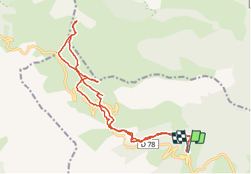
Tocht Sneeuwschoenen van 11,4 km beschikbaar op Provence-Alpes-Côte d'Azur, Alpes-Maritimes, Saint-Martin-d'Entraunes. Deze tocht wordt voorgesteld door bozo1970.
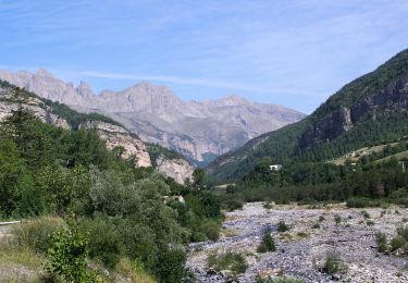
Beschrijving
Départ Val Pelens
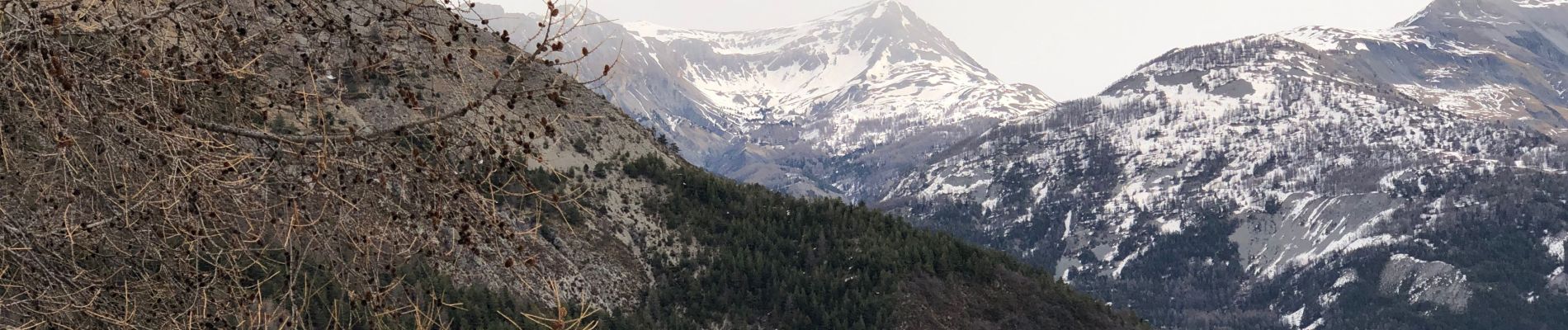
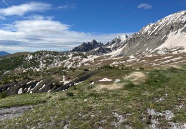
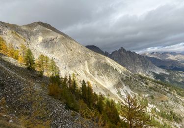
Montée au col des champs en passant par la Cîme de Voya
Belle vue sur les aiguilles de Pelens, le sommet de la Frema, la dent de Lièvre et la cîme de Pal
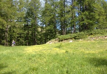
Sortie light avec le chien
Plaatsbepaling
Land:
France
Regio :
Provence-Alpes-Côte d'Azur
Departement/Provincie :
Alpes-Maritimes
Gemeente :
Saint-Martin-d'Entraunes
Locatie:
Unknown
Vertrek:(Dec)
Vertrek:(UTM)
318543 ; 4891863 (32T) N.
Opmerkingen
Wandeltochten in de omgeving
![Tocht Te voet Saint-Martin-d'Entraunes - Boucle de Pelens - Photo](https://media.geolcdn.com/t/375/260/599d17d9-363f-4210-a048-734d8f9e8c07.jpeg&format=jpg&maxdim=2)
![Te voet Te voet](https://static1.geolcdn.com/sitytour/trail-icons/100.png)
Boucle de Pelens
Te voet
Gemakkelijk
Saint-Martin-d'Entraunes,
Provence-Alpes-Côte d'Azur,
Alpes-Maritimes,
France
![](/images/other/stat-length.png)
9 km | 17,6 km-effort
3h 59min
![](https://static1.geolcdn.com/siteimages/upload/files/16400158638029165_repeat_loop_refresh_sync_direction_icon.png)
Ja
![Tocht Te voet Villeneuve-d'Entraunes - Circuit Enaux-Sussis - Photo](https://media.geolcdn.com/t/375/260/8f87238f-42fa-40a1-a80f-8030601f802a.jpeg&format=jpg&maxdim=2)
![Te voet Te voet](https://static1.geolcdn.com/sitytour/trail-icons/100.png)
Circuit Enaux-Sussis
Te voet
Medium
Villeneuve-d'Entraunes,
Provence-Alpes-Côte d'Azur,
Alpes-Maritimes,
France
![](/images/other/stat-length.png)
13,1 km | 23 km-effort
5h 8min
![](https://static1.geolcdn.com/siteimages/upload/files/16400158638029165_repeat_loop_refresh_sync_direction_icon.png)
Ja
![Tocht Stappen Saint-Martin-d'Entraunes - Tête de l’Encombrette - Photo](https://media.geolcdn.com/t/375/260/236d9d6e-bf01-4b0d-a6b0-e10b7b571a51.jpg&format=jpg&maxdim=2)
![Stappen Stappen](https://static1.geolcdn.com/sitytour/trail-icons/101.png)
Tête de l’Encombrette
Stappen
Zeer moeilijk
Saint-Martin-d'Entraunes,
Provence-Alpes-Côte d'Azur,
Alpes-Maritimes,
France
![](/images/other/stat-length.png)
9,8 km | 19,7 km-effort
4h 55min
![](https://static1.geolcdn.com/siteimages/upload/files/16400158638029165_repeat_loop_refresh_sync_direction_icon.png)
Ja
![Tocht Stappen Saint-Martin-d'Entraunes - Puy du Pas Roubinous - Photo](https://media.geolcdn.com/t/375/260/38a3e16d-3566-4ee5-8aa2-5a9a4fe61fff.jpg&format=jpg&maxdim=2)
![Stappen Stappen](https://static1.geolcdn.com/sitytour/trail-icons/101.png)
Puy du Pas Roubinous
Stappen
Moeilijk
Saint-Martin-d'Entraunes,
Provence-Alpes-Côte d'Azur,
Alpes-Maritimes,
France
![](/images/other/stat-length.png)
12,8 km | 27 km-effort
4h 53min
![](https://static1.geolcdn.com/siteimages/upload/files/16400158638029165_repeat_loop_refresh_sync_direction_icon.png)
Ja
![Tocht Stappen Saint-Martin-d'Entraunes - Mercantour Val Pelens Clos d'Aï - Photo](https://media.geolcdn.com/t/375/260/ext.jpg?maxdim=2&url=https%3A%2F%2Fservices.sitytrail.com%2FGeolivesWS%2FDownloadMedia.ashx%3FTrailID%3D135666%26Media%3D20120625100445.jpg)
![Stappen Stappen](https://static1.geolcdn.com/sitytour/trail-icons/101.png)
Mercantour Val Pelens Clos d'Aï
Stappen
Medium
Saint-Martin-d'Entraunes,
Provence-Alpes-Côte d'Azur,
Alpes-Maritimes,
France
![](/images/other/stat-length.png)
12 km | 21 km-effort
4h 22min
![](https://static1.geolcdn.com/siteimages/upload/files/16400158638029165_repeat_loop_refresh_sync_direction_icon.png)
Ja
![Tocht Trail Entraunes - couesto. oustaruma - Photo](https://media.geolcdn.com/t/375/260/b3464418-f180-4960-a3fa-b7e3291a1921.jpg&format=jpg&maxdim=2)
![Trail Trail](https://static1.geolcdn.com/sitytour/trail-icons/104.png)
couesto. oustaruma
Trail
Heel gemakkelijk
Entraunes,
Provence-Alpes-Côte d'Azur,
Alpes-Maritimes,
France
![](/images/other/stat-length.png)
14,1 km | 27 km-effort
2h 48min
![](https://static1.geolcdn.com/siteimages/upload/files/16400158638029165_repeat_loop_refresh_sync_direction_icon.png)
Neen
![Tocht Stappen Entraunes - rando estenc - Photo](https://media.geolcdn.com/t/375/260/ext.jpg?maxdim=2&url=https%3A%2F%2Fstatic1.geolcdn.com%2Fsiteimages%2Fupload%2Ffiles%2F1553511878bg_sport_marche.png)
![Stappen Stappen](https://static1.geolcdn.com/sitytour/trail-icons/101.png)
rando estenc
Stappen
Medium
Entraunes,
Provence-Alpes-Côte d'Azur,
Alpes-Maritimes,
France
![](/images/other/stat-length.png)
14,2 km | 24 km-effort
8h 39min
![](https://static1.geolcdn.com/siteimages/upload/files/16400158638029165_repeat_loop_refresh_sync_direction_icon.png)
Neen
![Tocht Stappen Saint-Martin-d'Entraunes - Boucle de Pelens - Photo](https://media.geolcdn.com/t/375/260/ext.jpg?maxdim=2&url=https%3A%2F%2Fstatic1.geolcdn.com%2Fsiteimages%2Fupload%2Ffiles%2F1553511878bg_sport_marche.png)
![Stappen Stappen](https://static1.geolcdn.com/sitytour/trail-icons/101.png)
Boucle de Pelens
Stappen
Gemakkelijk
Saint-Martin-d'Entraunes,
Provence-Alpes-Côte d'Azur,
Alpes-Maritimes,
France
![](/images/other/stat-length.png)
10,5 km | 18,9 km-effort
5h 26min
![](https://static1.geolcdn.com/siteimages/upload/files/16400158638029165_repeat_loop_refresh_sync_direction_icon.png)
Ja
![Tocht Andere activiteiten Colmars - Gorges 2 - Photo](https://media.geolcdn.com/t/375/260/ext.jpg?maxdim=2&url=https%3A%2F%2Fstatic1.geolcdn.com%2Fsiteimages%2Fupload%2Ffiles%2F1545311037marcheuse_200dpi.jpg)
![Andere activiteiten Andere activiteiten](https://static1.geolcdn.com/sitytour/trail-icons/900.png)
Gorges 2
Andere activiteiten
Heel gemakkelijk
Colmars,
Provence-Alpes-Côte d'Azur,
Alpes-de-Haute-Provence,
France
![](/images/other/stat-length.png)
16,8 km | 26 km-effort
7h 18min
![](https://static1.geolcdn.com/siteimages/upload/files/16400158638029165_repeat_loop_refresh_sync_direction_icon.png)
Ja