![](/images/other/stat-length.png)
![Tocht Stappen Soulan - Tour de Buleix - Photo](https://media.geolcdn.com/t/1900/400/ext.pjpeg?maxdim=2&url=https%3A%2F%2Fstatic1.geolcdn.com%2Fsiteimages%2Fupload%2Ffiles%2F1553511878bg_sport_marche.png)
Tour de Buleix
mccadars
Gebruiker
![Lengte](/images/other/stat-length.png)
Lengte
8 km
![Max. hoogte](https://static1.geolcdn.com/siteimages/upload/files/1508320355ic_sort_altitude_max_24dp.png)
Max. hoogte
822 m
![Positief hoogteverschil](https://static1.geolcdn.com/siteimages/upload/files/1508320355ic_sort_den_pos_24dp.png)
Positief hoogteverschil
286 m
![Km-Effort](/images/other/stat-length.png)
Km-Effort
11,9 km
![Min. hoogte](https://static1.geolcdn.com/siteimages/upload/files/1508320355ic_sort_altitude_min_24dp.png)
Min. hoogte
508 m
![Negatief hoogteverschil](https://static1.geolcdn.com/siteimages/upload/files/1508320355ic_sort_den_neg_24dp.png)
Negatief hoogteverschil
311 m
![Boucle](https://static1.geolcdn.com/siteimages/upload/files/16400158638029165_repeat_loop_refresh_sync_direction_icon.png)
Boucle
Ja
Datum van aanmaak :
2021-02-24 14:02:40.0
Laatste wijziging :
2021-02-25 14:04:07.232
![Stappen](https://static1.geolcdn.com/sitytour/trail-icons/101.png)
3h00
Moeilijkheid : Heel gemakkelijk
![Scan deze QR-code om de tocht te openen in de SityTrail-applicatie](https://capi.geolives.com/qq0zvz2zws4bq2lad0pu/sitytour/trails/2684646/qr.png?size=200)
Gratisgps-wandelapplicatie
Over ons
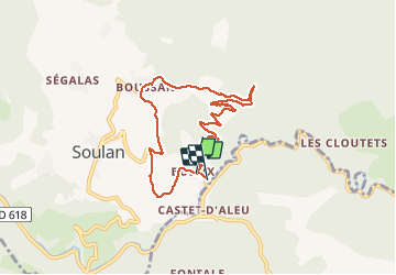
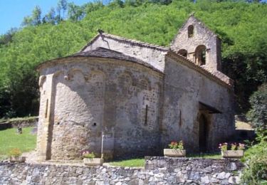
Tocht Stappen van 8 km beschikbaar op Occitanië, Ariège, Soulan. Deze tocht wordt voorgesteld door mccadars.
Beschrijving
Chemins forestiers ou portions de routes très peu fréquentées puis sentiers
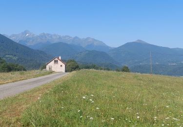
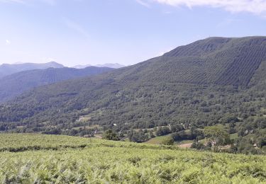
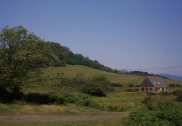
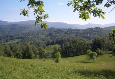
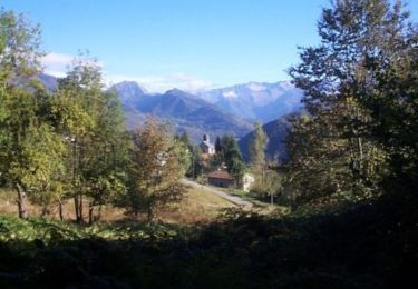
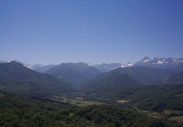
Vue sur les massifs tout le long de la randonnée
Plaatsbepaling
Land:
France
Regio :
Occitanië
Departement/Provincie :
Ariège
Gemeente :
Soulan
Locatie:
Unknown
Vertrek:(Dec)
Vertrek:(UTM)
356996 ; 4752368 (31T) N.
Opmerkingen
Wandeltochten in de omgeving
![Tocht Elektrische fiets Soueix-Rogalle - st girons rogalle 21/06 - Photo](https://media.geolcdn.com/t/375/260/ext.jpg?maxdim=2&url=https%3A%2F%2Fmedia.geolcdn.com%2Ff%2F0290fbc5-b582-4db6-9d72-0a6976ab2518.jpg)
![Elektrische fiets Elektrische fiets](https://static1.geolcdn.com/sitytour/trail-icons/205.png)
st girons rogalle 21/06
Elektrische fiets
Moeilijk
Soueix-Rogalle,
Occitanië,
Ariège,
France
![](/images/other/stat-length.png)
27 km | 42 km-effort
5h 33min
![](https://static1.geolcdn.com/siteimages/upload/files/16400158638029165_repeat_loop_refresh_sync_direction_icon.png)
Neen
![Tocht Mountainbike Soueix-Rogalle - La Vallée de Laspieng - Photo](https://media.geolcdn.com/t/375/260/ext.jpg?maxdim=2&url=https%3A%2F%2Fservices.sitytrail.com%2FGeolivesWS%2FDownloadMedia.ashx%3FTrailID%3D109225%26Media%3D3303_1.jpg)
![Mountainbike Mountainbike](https://static1.geolcdn.com/sitytour/trail-icons/202.png)
La Vallée de Laspieng
Mountainbike
Medium
Soueix-Rogalle,
Occitanië,
Ariège,
France
![](/images/other/stat-length.png)
10,3 km | 16,6 km-effort
1h 49min
![](https://static1.geolcdn.com/siteimages/upload/files/16400158638029165_repeat_loop_refresh_sync_direction_icon.png)
Ja
![Tocht Stappen Soueix-Rogalle - La Vallée de Laspieng - Photo](https://media.geolcdn.com/t/375/260/ext.jpg?maxdim=2&url=https%3A%2F%2Fservices.sitytrail.com%2FGeolivesWS%2FDownloadMedia.ashx%3FTrailID%3D109224%26Media%3D3303_1.jpg)
![Stappen Stappen](https://static1.geolcdn.com/sitytour/trail-icons/101.png)
La Vallée de Laspieng
Stappen
Moeilijk
Soueix-Rogalle,
Occitanië,
Ariège,
France
![](/images/other/stat-length.png)
10,3 km | 16,6 km-effort
3h 49min
![](https://static1.geolcdn.com/siteimages/upload/files/16400158638029165_repeat_loop_refresh_sync_direction_icon.png)
Ja
![Tocht Stappen Ercé - Le tour du Régudé - Photo](https://media.geolcdn.com/t/375/260/ext.jpg?maxdim=2&url=https%3A%2F%2Fservices.sitytrail.com%2FGeolivesWS%2FDownloadMedia.ashx%3FTrailID%3D109221%26Media%3D3301_1.jpg)
![Stappen Stappen](https://static1.geolcdn.com/sitytour/trail-icons/101.png)
Le tour du Régudé
Stappen
Moeilijk
Ercé,
Occitanië,
Ariège,
France
![](/images/other/stat-length.png)
14,7 km | 22 km-effort
4h 49min
![](https://static1.geolcdn.com/siteimages/upload/files/16400158638029165_repeat_loop_refresh_sync_direction_icon.png)
Ja
![Tocht Mountainbike Soueix-Rogalle - La Passéjade - Photo](https://media.geolcdn.com/t/375/260/ext.jpg?maxdim=2&url=https%3A%2F%2Fservices.sitytrail.com%2FGeolivesWS%2FDownloadMedia.ashx%3FTrailID%3D109217%26Media%3D3294_1.jpg)
![Mountainbike Mountainbike](https://static1.geolcdn.com/sitytour/trail-icons/202.png)
La Passéjade
Mountainbike
Medium
Soueix-Rogalle,
Occitanië,
Ariège,
France
![](/images/other/stat-length.png)
5,3 km | 8,3 km-effort
45min
![](https://static1.geolcdn.com/siteimages/upload/files/16400158638029165_repeat_loop_refresh_sync_direction_icon.png)
Ja
![Tocht Stappen Soueix-Rogalle - La Passéjade - Photo](https://media.geolcdn.com/t/375/260/ext.jpg?maxdim=2&url=https%3A%2F%2Fservices.sitytrail.com%2FGeolivesWS%2FDownloadMedia.ashx%3FTrailID%3D109216%26Media%3D3294_1.jpg)
![Stappen Stappen](https://static1.geolcdn.com/sitytour/trail-icons/101.png)
La Passéjade
Stappen
Medium
Soueix-Rogalle,
Occitanië,
Ariège,
France
![](/images/other/stat-length.png)
5,3 km | 8,3 km-effort
1h 45min
![](https://static1.geolcdn.com/siteimages/upload/files/16400158638029165_repeat_loop_refresh_sync_direction_icon.png)
Ja
![Tocht Stappen Ercé - Les Ecureuils autour de Cominac - Photo](https://media.geolcdn.com/t/375/260/ext.jpg?maxdim=2&url=https%3A%2F%2Fservices.sitytrail.com%2FGeolivesWS%2FDownloadMedia.ashx%3FTrailID%3D109213%26Media%3D3292_1.jpg)
![Stappen Stappen](https://static1.geolcdn.com/sitytour/trail-icons/101.png)
Les Ecureuils autour de Cominac
Stappen
Medium
Ercé,
Occitanië,
Ariège,
France
![](/images/other/stat-length.png)
8,5 km | 12,9 km-effort
2h 30min
![](https://static1.geolcdn.com/siteimages/upload/files/16400158638029165_repeat_loop_refresh_sync_direction_icon.png)
Ja
![Tocht Paard Oust - La Serre de Rapheu par le Pas de Sausech - Photo](https://media.geolcdn.com/t/375/260/ext.jpg?maxdim=2&url=https%3A%2F%2Fservices.sitytrail.com%2FGeolivesWS%2FDownloadMedia.ashx%3FTrailID%3D109208%26Media%3D3287_1.jpg)
![Paard Paard](https://static1.geolcdn.com/sitytour/trail-icons/300.png)
La Serre de Rapheu par le Pas de Sausech
Paard
Moeilijk
Oust,
Occitanië,
Ariège,
France
![](/images/other/stat-length.png)
7,1 km | 11,4 km-effort
1h 30min
![](https://static1.geolcdn.com/siteimages/upload/files/16400158638029165_repeat_loop_refresh_sync_direction_icon.png)
Ja
![Tocht Mountainbike Oust - La Serre de Rapheu par le Pas de Sausech - Photo](https://media.geolcdn.com/t/375/260/ext.jpg?maxdim=2&url=https%3A%2F%2Fservices.sitytrail.com%2FGeolivesWS%2FDownloadMedia.ashx%3FTrailID%3D109207%26Media%3D3287_1.jpg)
![Mountainbike Mountainbike](https://static1.geolcdn.com/sitytour/trail-icons/202.png)
La Serre de Rapheu par le Pas de Sausech
Mountainbike
Medium
Oust,
Occitanië,
Ariège,
France
![](/images/other/stat-length.png)
7,1 km | 11,4 km-effort
1h 0min
![](https://static1.geolcdn.com/siteimages/upload/files/16400158638029165_repeat_loop_refresh_sync_direction_icon.png)
Ja