![](/images/other/stat-length.png)
![Tocht Stappen Étaples - Le sentier du Rombly - Etaples - Photo](https://media.geolcdn.com/t/1900/400/ext.pjpeg?maxdim=2&url=https%3A%2F%2Fservices.sitytrail.com%2FGeolivesWS%2FDownloadMedia.ashx%3FTrailID%3D267466%26Media%3Da0e1581c-91ea-4662-98e0-0f804ee4a0e7.jpg)
Le sentier du Rombly - Etaples
Maca8284
Gebruiker
![Lengte](/images/other/stat-length.png)
![Max. hoogte](https://static1.geolcdn.com/siteimages/upload/files/1508320355ic_sort_altitude_max_24dp.png)
![Positief hoogteverschil](https://static1.geolcdn.com/siteimages/upload/files/1508320355ic_sort_den_pos_24dp.png)
![Km-Effort](/images/other/stat-length.png)
![Min. hoogte](https://static1.geolcdn.com/siteimages/upload/files/1508320355ic_sort_altitude_min_24dp.png)
![Negatief hoogteverschil](https://static1.geolcdn.com/siteimages/upload/files/1508320355ic_sort_den_neg_24dp.png)
![Boucle](https://static1.geolcdn.com/siteimages/upload/files/16400158638029165_repeat_loop_refresh_sync_direction_icon.png)
![Stappen](https://static1.geolcdn.com/sitytour/trail-icons/101.png)
3h30
Moeilijkheid : Moeilijk
![Scan deze QR-code om de tocht te openen in de SityTrail-applicatie](https://capi.geolives.com/qq0zvz2zws4bq2lad0pu/sitytour/trails/267466/qr.png?size=200)
Gratisgps-wandelapplicatie
Over ons
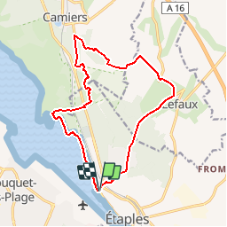
Tocht Stappen van 14,1 km beschikbaar op Hauts-de-France, Pas-de-Calais, Étaples. Deze tocht wordt voorgesteld door Maca8284.
Beschrijving
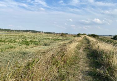
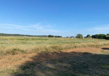
Circuit proposé par la Communauté de Communes Mer & Terres d’Opale et l’Office de Tourisme d’Etaples sur Mer. Départ du centre nautique d’Etaples. Circuit hors du commun, le sentier de Rombly expose implicitement la lutte historique et permanente de la mouvance des terres et des eaux. Vous serpenterez dans la Réserve Naturelle de la Baie de Canche, jusqu’au bois de Rombly, nom en souvenir de cet ancien village qui fût recouvert par les sables au Moyen Age (1646). Retrouvez le Plan du Circuit sur le site de la Communauté de Communes Mer & Terres d’Opale. Ce circuit a été numérisé par les randonneurs du CODEPEM. Merci à Jean-Marie.
Plaatsbepaling
Opmerkingen
Wandeltochten in de omgeving
![Tocht Fiets Étaples - Les Garnoulles - Etaples - Photo](https://media.geolcdn.com/t/375/260/ext.jpg?maxdim=2&url=https%3A%2F%2Fservices.sitytrail.com%2FGeolivesWS%2FDownloadMedia.ashx%3FTrailID%3D110038%26Media%3D5140_6.jpg)
![Fiets Fiets](https://static1.geolcdn.com/sitytour/trail-icons/200.png)
Fiets
![](/images/other/stat-length.png)
![](https://static1.geolcdn.com/siteimages/upload/files/16400158638029165_repeat_loop_refresh_sync_direction_icon.png)
![Tocht Stappen Étaples - Le sentier du Rombly - Etaples - Photo](https://media.geolcdn.com/t/375/260/ext.jpg?maxdim=2&url=https%3A%2F%2Fservices.sitytrail.com%2FGeolivesWS%2FDownloadMedia.ashx%3FTrailID%3D110030%26Media%3D5135_5.jpg)
![Stappen Stappen](https://static1.geolcdn.com/sitytour/trail-icons/101.png)
Stappen
![](/images/other/stat-length.png)
![](https://static1.geolcdn.com/siteimages/upload/files/16400158638029165_repeat_loop_refresh_sync_direction_icon.png)
![Tocht Te voet Étaples - Sentier de Rombly - Photo](https://media.geolcdn.com/t/375/260/91fe37b4-244e-4fc8-8ef4-3e25b2d6c241.jpeg&format=jpg&maxdim=2)
![Te voet Te voet](https://static1.geolcdn.com/sitytour/trail-icons/100.png)
Te voet
![](/images/other/stat-length.png)
![](https://static1.geolcdn.com/siteimages/upload/files/16400158638029165_repeat_loop_refresh_sync_direction_icon.png)
![Tocht Noords wandelen Le Touquet-Paris-Plage - Marche nordique : Boucle 12 km Le Touquet - Merlimont - Photo](https://media.geolcdn.com/t/375/260/3f68287f-5493-43e5-98e0-b8e122cf61f9.jpg&format=jpg&maxdim=2)
![Noords wandelen Noords wandelen](https://static1.geolcdn.com/sitytour/trail-icons/102.png)
Noords wandelen
![](/images/other/stat-length.png)
![](https://static1.geolcdn.com/siteimages/upload/files/16400158638029165_repeat_loop_refresh_sync_direction_icon.png)
![Tocht Stappen Le Touquet-Paris-Plage - Sur la route du musée - Photo](https://media.geolcdn.com/t/375/260/62c5aadb-0410-4785-8e61-ddcf957a5ea7.jpg&format=jpg&maxdim=2)
![Stappen Stappen](https://static1.geolcdn.com/sitytour/trail-icons/101.png)
Stappen
![](/images/other/stat-length.png)
![](https://static1.geolcdn.com/siteimages/upload/files/16400158638029165_repeat_loop_refresh_sync_direction_icon.png)
![Tocht Stappen Le Touquet-Paris-Plage - Balade dans la baie de Canche - Photo](https://media.geolcdn.com/t/375/260/3dc28a84-57d0-46cf-b02e-bd5974f0e2ec.jpg&format=jpg&maxdim=2)
![Stappen Stappen](https://static1.geolcdn.com/sitytour/trail-icons/101.png)
Stappen
![](/images/other/stat-length.png)
![](https://static1.geolcdn.com/siteimages/upload/files/16400158638029165_repeat_loop_refresh_sync_direction_icon.png)
![Tocht Stappen Étaples - Étaples - La forestière - Photo](https://media.geolcdn.com/t/375/260/ea83baf0-4684-4df5-9be2-2a2c1d93a866.jpg&format=jpg&maxdim=2)
![Stappen Stappen](https://static1.geolcdn.com/sitytour/trail-icons/101.png)
Stappen
![](/images/other/stat-length.png)
![](https://static1.geolcdn.com/siteimages/upload/files/16400158638029165_repeat_loop_refresh_sync_direction_icon.png)
![Tocht Wegfiets Le Touquet-Paris-Plage - Le Touquet Vélo - Photo](https://media.geolcdn.com/t/375/260/d0d444ac-fb80-4612-9631-6d43cd426718.jpg&format=jpg&maxdim=2)
![Wegfiets Wegfiets](https://static1.geolcdn.com/sitytour/trail-icons/201.png)
Wegfiets
![](/images/other/stat-length.png)
![](https://static1.geolcdn.com/siteimages/upload/files/16400158638029165_repeat_loop_refresh_sync_direction_icon.png)
![Tocht Stappen Le Touquet-Paris-Plage - Le Touquet Paris Plage - Photo](https://media.geolcdn.com/t/375/260/58cf07f6-f257-4be4-a8f7-0f5714037a5d.jpg&format=jpg&maxdim=2)
![Stappen Stappen](https://static1.geolcdn.com/sitytour/trail-icons/101.png)
Stappen
![](/images/other/stat-length.png)
![](https://static1.geolcdn.com/siteimages/upload/files/16400158638029165_repeat_loop_refresh_sync_direction_icon.png)