![](/images/other/stat-length.png)
2021-02-11 Sortie CAF - Les Angles - vers les Camporells
eric.mignot
Gebruiker
![Lengte](/images/other/stat-length.png)
Lengte
16,8 km
![Max. hoogte](https://static1.geolcdn.com/siteimages/upload/files/1508320355ic_sort_altitude_max_24dp.png)
Max. hoogte
2267 m
![Positief hoogteverschil](https://static1.geolcdn.com/siteimages/upload/files/1508320355ic_sort_den_pos_24dp.png)
Positief hoogteverschil
510 m
![Km-Effort](/images/other/stat-length.png)
Km-Effort
24 km
![Min. hoogte](https://static1.geolcdn.com/siteimages/upload/files/1508320355ic_sort_altitude_min_24dp.png)
Min. hoogte
1834 m
![Negatief hoogteverschil](https://static1.geolcdn.com/siteimages/upload/files/1508320355ic_sort_den_neg_24dp.png)
Negatief hoogteverschil
510 m
![Boucle](https://static1.geolcdn.com/siteimages/upload/files/16400158638029165_repeat_loop_refresh_sync_direction_icon.png)
Boucle
Ja
Datum van aanmaak :
2021-02-11 08:16:07.503
Laatste wijziging :
2024-01-17 09:49:00.933
![Sneeuwschoenen](https://static1.geolcdn.com/sitytour/trail-icons/504.png)
7h00
Moeilijkheid : Medium
![Scan deze QR-code om de tocht te openen in de SityTrail-applicatie](https://capi.geolives.com/qq0zvz2zws4bq2lad0pu/sitytour/trails/2667560/qr.png?size=200)
Gratisgps-wandelapplicatie
Over ons
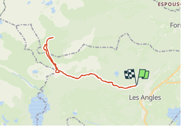
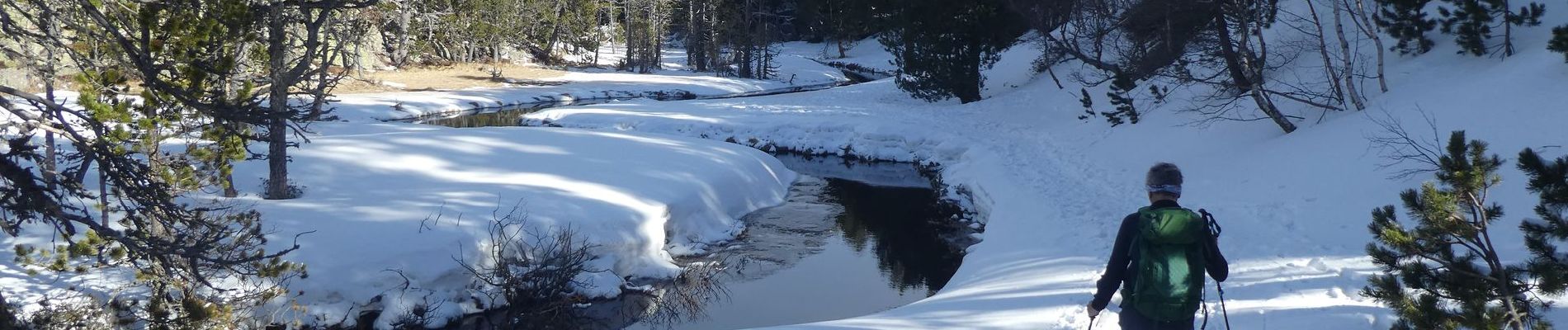
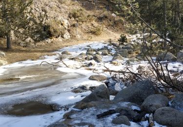
Tocht Sneeuwschoenen van 16,8 km beschikbaar op Occitanië, Pyrénées-Orientales, Les Angles. Deze tocht wordt voorgesteld door eric.mignot.
Beschrijving
depuis le haut de la station des Angles, en direction du refuge des Camporells, par l'estany de la Balmeta
Plaatsbepaling
Land:
France
Regio :
Occitanië
Departement/Provincie :
Pyrénées-Orientales
Gemeente :
Les Angles
Locatie:
Unknown
Vertrek:(Dec)
Vertrek:(UTM)
423470 ; 4715001 (31T) N.
Opmerkingen
Wandeltochten in de omgeving
![Tocht Sneeuwschoenen Les Angles - Lac d Aude -Refuge Bernardi les Angles - Photo](https://media.geolcdn.com/t/375/260/ext.jpg?maxdim=2&url=https%3A%2F%2Fservices.sitytrail.com%2FGeolivesWS%2FDownloadMedia.ashx%3FTrailID%3D400729%26Media%3Dfix__20150327134406.jpg)
![Sneeuwschoenen Sneeuwschoenen](https://static1.geolcdn.com/sitytour/trail-icons/504.png)
Lac d Aude -Refuge Bernardi les Angles
Sneeuwschoenen
Medium
(1)
Les Angles,
Occitanië,
Pyrénées-Orientales,
France
![](/images/other/stat-length.png)
13,9 km | 19,1 km-effort
5h 44min
![](https://static1.geolcdn.com/siteimages/upload/files/16400158638029165_repeat_loop_refresh_sync_direction_icon.png)
Ja
![Tocht Stappen Les Angles - lac d'Aude - Photo](https://media.geolcdn.com/t/375/260/dc6c3cf8-db43-4620-818b-ca96b3366767.jpg&format=jpg&maxdim=2)
![Stappen Stappen](https://static1.geolcdn.com/sitytour/trail-icons/101.png)
lac d'Aude
Stappen
Medium
Les Angles,
Occitanië,
Pyrénées-Orientales,
France
![](/images/other/stat-length.png)
13,8 km | 0 m-effort
5h 57min
![](https://static1.geolcdn.com/siteimages/upload/files/16400158638029165_repeat_loop_refresh_sync_direction_icon.png)
Ja
![Tocht Stappen Les Angles - Lac d'Aude en boucle - Photo](https://media.geolcdn.com/t/375/260/bb545742-b218-4a2b-8572-21d45496180e.jpg&format=jpg&maxdim=2)
![Stappen Stappen](https://static1.geolcdn.com/sitytour/trail-icons/101.png)
Lac d'Aude en boucle
Stappen
Medium
Les Angles,
Occitanië,
Pyrénées-Orientales,
France
![](/images/other/stat-length.png)
13,8 km | 19,9 km-effort
6h 8min
![](https://static1.geolcdn.com/siteimages/upload/files/16400158638029165_repeat_loop_refresh_sync_direction_icon.png)
Ja
![Tocht Stappen Les Angles - les Angles - Photo](https://media.geolcdn.com/t/375/260/a1624f8b-9696-405f-8c28-1fd4c2634375.jpg&format=jpg&maxdim=2)
![Stappen Stappen](https://static1.geolcdn.com/sitytour/trail-icons/101.png)
les Angles
Stappen
Moeilijk
Les Angles,
Occitanië,
Pyrénées-Orientales,
France
![](/images/other/stat-length.png)
14,5 km | 20 km-effort
4h 58min
![](https://static1.geolcdn.com/siteimages/upload/files/16400158638029165_repeat_loop_refresh_sync_direction_icon.png)
Neen
![Tocht Stappen Formiguères - Les Camporells par la Lladure - Photo](https://media.geolcdn.com/t/375/260/ext.jpg?maxdim=2&url=https%3A%2F%2Fstatic1.geolcdn.com%2Fsiteimages%2Fupload%2Ffiles%2F1553511878bg_sport_marche.png)
![Stappen Stappen](https://static1.geolcdn.com/sitytour/trail-icons/101.png)
Les Camporells par la Lladure
Stappen
Medium
(1)
Formiguères,
Occitanië,
Pyrénées-Orientales,
France
![](/images/other/stat-length.png)
15,1 km | 24 km-effort
5h 7min
![](https://static1.geolcdn.com/siteimages/upload/files/16400158638029165_repeat_loop_refresh_sync_direction_icon.png)
Ja
![Tocht Sneeuwschoenen Les Angles - lac d aude - Photo](https://media.geolcdn.com/t/375/260/ext.jpg?maxdim=2&url=https%3A%2F%2Fstatic1.geolcdn.com%2Fsiteimages%2Fupload%2Ffiles%2F1524743153raquette.jpg)
![Sneeuwschoenen Sneeuwschoenen](https://static1.geolcdn.com/sitytour/trail-icons/504.png)
lac d aude
Sneeuwschoenen
Heel gemakkelijk
(2)
Les Angles,
Occitanië,
Pyrénées-Orientales,
France
![](/images/other/stat-length.png)
14,5 km | 20 km-effort
Onbekend
![](https://static1.geolcdn.com/siteimages/upload/files/16400158638029165_repeat_loop_refresh_sync_direction_icon.png)
Ja
![Tocht Stappen Les Angles - boucle de la Balmette par le mont Llaret et le roc d'aude - Photo](https://media.geolcdn.com/t/375/260/ext.jpg?maxdim=2&url=https%3A%2F%2Fstatic1.geolcdn.com%2Fsiteimages%2Fupload%2Ffiles%2F1553511878bg_sport_marche.png)
![Stappen Stappen](https://static1.geolcdn.com/sitytour/trail-icons/101.png)
boucle de la Balmette par le mont Llaret et le roc d'aude
Stappen
Medium
(2)
Les Angles,
Occitanië,
Pyrénées-Orientales,
France
![](/images/other/stat-length.png)
17,2 km | 28 km-effort
Onbekend
![](https://static1.geolcdn.com/siteimages/upload/files/16400158638029165_repeat_loop_refresh_sync_direction_icon.png)
Ja
![Tocht sport Formiguères - 20240728 Station Formiguères - Camporeils - Photo](https://media.geolcdn.com/t/375/260/f876415d-ce02-429d-b141-5520f07207a5.jpg&format=jpg&maxdim=2)
20240728 Station Formiguères - Camporeils
sport
Heel gemakkelijk
Formiguères,
Occitanië,
Pyrénées-Orientales,
France
![](/images/other/stat-length.png)
16 km | 27 km-effort
Onbekend
![](https://static1.geolcdn.com/siteimages/upload/files/16400158638029165_repeat_loop_refresh_sync_direction_icon.png)
Ja
![Tocht Stappen La Llagonne - 2024-01-22 Les bouillouses - Photo](https://media.geolcdn.com/t/375/260/00fa4e59-6f74-4341-a071-bd92950f8772.jpg&format=jpg&maxdim=2)
![Stappen Stappen](https://static1.geolcdn.com/sitytour/trail-icons/101.png)
2024-01-22 Les bouillouses
Stappen
Moeilijk
La Llagonne,
Occitanië,
Pyrénées-Orientales,
France
![](/images/other/stat-length.png)
10,3 km | 15 km-effort
3h 25min
![](https://static1.geolcdn.com/siteimages/upload/files/16400158638029165_repeat_loop_refresh_sync_direction_icon.png)
Ja