![](/images/other/stat-length.png)
![Tocht Te voet Serres-Morlaàs - 2021-02-08_18h29m06_M2-Serres-Morlaas 8 km - Photo](https://media.geolcdn.com/t/1900/400/ext.pjpeg?maxdim=2&url=https%3A%2F%2Fstatic1.geolcdn.com%2Fsiteimages%2Fupload%2Ffiles%2F1545311037marcheuse_200dpi.jpg)
2021-02-08_18h29m06_M2-Serres-Morlaas 8 km
mitch1952
Gebruiker
![Lengte](/images/other/stat-length.png)
Lengte
8,1 km
![Max. hoogte](https://static1.geolcdn.com/siteimages/upload/files/1508320355ic_sort_altitude_max_24dp.png)
Max. hoogte
327 m
![Positief hoogteverschil](https://static1.geolcdn.com/siteimages/upload/files/1508320355ic_sort_den_pos_24dp.png)
Positief hoogteverschil
108 m
![Km-Effort](/images/other/stat-length.png)
Km-Effort
9,6 km
![Min. hoogte](https://static1.geolcdn.com/siteimages/upload/files/1508320355ic_sort_altitude_min_24dp.png)
Min. hoogte
246 m
![Negatief hoogteverschil](https://static1.geolcdn.com/siteimages/upload/files/1508320355ic_sort_den_neg_24dp.png)
Negatief hoogteverschil
107 m
![Boucle](https://static1.geolcdn.com/siteimages/upload/files/16400158638029165_repeat_loop_refresh_sync_direction_icon.png)
Boucle
Ja
Datum van aanmaak :
2021-02-08 17:29:06.192
Laatste wijziging :
2022-06-07 13:59:28.857
![Te voet](https://static1.geolcdn.com/sitytour/trail-icons/100.png)
2h10
Moeilijkheid : Gemakkelijk
![Scan deze QR-code om de tocht te openen in de SityTrail-applicatie](https://capi.geolives.com/qq0zvz2zws4bq2lad0pu/sitytour/trails/2664957/qr.png?size=200)
Gratisgps-wandelapplicatie
Over ons
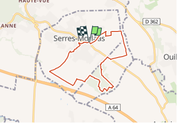
Tocht Te voet van 8,1 km beschikbaar op Nieuw-Aquitanië, Pyrénées-Atlantiques, Serres-Morlaàs. Deze tocht wordt voorgesteld door mitch1952.
Beschrijving
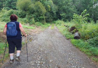
Très facile mais qqs flaques d'eau même par beau temps.
Pour le retour emprunter un chemin en herbe, qui montent entre les villas et où on découvre un jardin plein de sculptures en fer.
Plaatsbepaling
Land:
France
Regio :
Nieuw-Aquitanië
Departement/Provincie :
Pyrénées-Atlantiques
Gemeente :
Serres-Morlaàs
Locatie:
Unknown
Vertrek:(Dec)
Vertrek:(UTM)
722479 ; 4800576 (30T) N.
Opmerkingen
Wandeltochten in de omgeving
![Tocht Stappen Idron - Idron golf - Photo](https://media.geolcdn.com/t/375/260/ext.jpg?maxdim=2&url=https%3A%2F%2Fstatic1.geolcdn.com%2Fsiteimages%2Fupload%2Ffiles%2F1553511878bg_sport_marche.png)
![Stappen Stappen](https://static1.geolcdn.com/sitytour/trail-icons/101.png)
Idron golf
Stappen
Heel gemakkelijk
(1)
Idron,
Nieuw-Aquitanië,
Pyrénées-Atlantiques,
France
![](/images/other/stat-length.png)
3,3 km | 3,6 km-effort
48min
![](https://static1.geolcdn.com/siteimages/upload/files/16400158638029165_repeat_loop_refresh_sync_direction_icon.png)
Ja
![Tocht sport Ouillon - MNS Ouillon - Photo](https://media.geolcdn.com/t/375/260/ext.jpg?maxdim=2&url=https%3A%2F%2Fsecurestorage.geolives.com%2Fsitytour%2Ftrail-bg%2Fdefault.jpg)
MNS Ouillon
sport
Heel gemakkelijk
(1)
Ouillon,
Nieuw-Aquitanië,
Pyrénées-Atlantiques,
France
![](/images/other/stat-length.png)
4,9 km | 5,3 km-effort
Onbekend
![](https://static1.geolcdn.com/siteimages/upload/files/16400158638029165_repeat_loop_refresh_sync_direction_icon.png)
Ja
![Tocht Te voet Saint-Jammes - BALISAGE GR653 A 2eme partie ABERE/ entrée de Morlaas /Pilar fait 2833880 - Photo](https://media.geolcdn.com/t/375/260/f993f3ce-6b4d-4b5a-bcb1-4f2620873f19.jpg&format=jpg&maxdim=2)
![Te voet Te voet](https://static1.geolcdn.com/sitytour/trail-icons/100.png)
BALISAGE GR653 A 2eme partie ABERE/ entrée de Morlaas /Pilar fait 2833880
Te voet
Gemakkelijk
Saint-Jammes,
Nieuw-Aquitanië,
Pyrénées-Atlantiques,
France
![](/images/other/stat-length.png)
11,6 km | 13,8 km-effort
3h 5min
![](https://static1.geolcdn.com/siteimages/upload/files/16400158638029165_repeat_loop_refresh_sync_direction_icon.png)
Neen
![Tocht Stappen Idron - IDRON La Micheloise M2- - Photo](https://media.geolcdn.com/t/375/260/2bbf73de-0d3e-4644-8dda-998d80ada584.jpg&format=jpg&maxdim=2)
![Stappen Stappen](https://static1.geolcdn.com/sitytour/trail-icons/101.png)
IDRON La Micheloise M2-
Stappen
Heel gemakkelijk
Idron,
Nieuw-Aquitanië,
Pyrénées-Atlantiques,
France
![](/images/other/stat-length.png)
8,4 km | 9,8 km-effort
2h 20min
![](https://static1.geolcdn.com/siteimages/upload/files/16400158638029165_repeat_loop_refresh_sync_direction_icon.png)
Ja
![Tocht Stappen Serres-Morlaàs - SERRES MORLAAS-MNT-R - Photo](https://media.geolcdn.com/t/375/260/ext.jpg?maxdim=2&url=https%3A%2F%2Fstatic1.geolcdn.com%2Fsiteimages%2Fupload%2Ffiles%2F1553511878bg_sport_marche.png)
![Stappen Stappen](https://static1.geolcdn.com/sitytour/trail-icons/101.png)
SERRES MORLAAS-MNT-R
Stappen
Gemakkelijk
(1)
Serres-Morlaàs,
Nieuw-Aquitanië,
Pyrénées-Atlantiques,
France
![](/images/other/stat-length.png)
4,6 km | 5,8 km-effort
1h 15min
![](https://static1.geolcdn.com/siteimages/upload/files/16400158638029165_repeat_loop_refresh_sync_direction_icon.png)
Ja
![Tocht Stappen Idron - IDRON avec Loulou sans palmes ni tuba - Photo](https://media.geolcdn.com/t/375/260/233f0820-9a44-4141-a58a-9a0c46ddcb62.jpg&format=jpg&maxdim=2)
![Stappen Stappen](https://static1.geolcdn.com/sitytour/trail-icons/101.png)
IDRON avec Loulou sans palmes ni tuba
Stappen
Gemakkelijk
Idron,
Nieuw-Aquitanië,
Pyrénées-Atlantiques,
France
![](/images/other/stat-length.png)
3,4 km | 3,7 km-effort
58min
![](https://static1.geolcdn.com/siteimages/upload/files/16400158638029165_repeat_loop_refresh_sync_direction_icon.png)
Ja
![Tocht Stappen Morlaàs - MORLAAS du LEP au luy - Photo](https://media.geolcdn.com/t/375/260/35e40e20-bb5d-45a4-84e4-8d8455e72b82.jpg&format=jpg&maxdim=2)
![Stappen Stappen](https://static1.geolcdn.com/sitytour/trail-icons/101.png)
MORLAAS du LEP au luy
Stappen
Medium
Morlaàs,
Nieuw-Aquitanië,
Pyrénées-Atlantiques,
France
![](/images/other/stat-length.png)
9 km | 11,6 km-effort
2h 38min
![](https://static1.geolcdn.com/siteimages/upload/files/16400158638029165_repeat_loop_refresh_sync_direction_icon.png)
Ja
![Tocht Stappen Morlaàs - GR653. A 2eme partie faite le 3/06/2022 - Photo](https://media.geolcdn.com/t/375/260/f5cbd3c1-303d-4ec7-98c9-dde5d8d19849.jpg&format=jpg&maxdim=2)
![Stappen Stappen](https://static1.geolcdn.com/sitytour/trail-icons/101.png)
GR653. A 2eme partie faite le 3/06/2022
Stappen
Medium
Morlaàs,
Nieuw-Aquitanië,
Pyrénées-Atlantiques,
France
![](/images/other/stat-length.png)
6,5 km | 7 km-effort
2h 11min
![](https://static1.geolcdn.com/siteimages/upload/files/16400158638029165_repeat_loop_refresh_sync_direction_icon.png)
Neen
![Tocht Stappen Idron - IDRON avec un I comme inedit - Photo](https://media.geolcdn.com/t/375/260/10593ebb-10b7-406d-9321-e7633b60e9af.jpg&format=jpg&maxdim=2)
![Stappen Stappen](https://static1.geolcdn.com/sitytour/trail-icons/101.png)
IDRON avec un I comme inedit
Stappen
Medium
Idron,
Nieuw-Aquitanië,
Pyrénées-Atlantiques,
France
![](/images/other/stat-length.png)
8,9 km | 10,4 km-effort
2h 6min
![](https://static1.geolcdn.com/siteimages/upload/files/16400158638029165_repeat_loop_refresh_sync_direction_icon.png)
Ja