Tocht Stappen Laurac - Laurac Le Grand Laurabuc - Photo

Laurac Le Grand Laurabuc

 caccini
caccini

Gebruiker

© OpenStreetMap contributors
Lengte
Lengte
10,9 km
Max. hoogte
Max. hoogte
394 m
Positief hoogteverschil
276 m
Km-Effort
Km-Effort  
14,6 km
Min. hoogte
Min. hoogte
181 m
Negatief hoogteverschil
274 m
Boucle
Boucle
Ja
Datum van aanmaak :
2021-02-03 12:27:39.359
Laatste wijziging :
2021-02-04 10:12:51.052

(1 Bericht)

Stappen
Stappen
3h23
Moeilijkheid : Gemakkelijk

Scan deze QR-code om de tocht te openen in de SityTrail-applicatie

Gratisgps-wandelapplicatie

Logo SityTrail SityTrail

IGN / Geografische instituten

SityTrail uit de App Store downloaden SityTrail uit Google Play downloaden

Logo SityTrail SityTrail World

De wereld gaat voor u open

SityTrail uit de App Store downloaden SityTrail uit Google Play downloaden SityTrail op Huawei AppGallery downloaden

Over ons

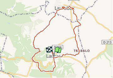
Tocht Stappen van 10,9 km beschikbaar op Occitanië, Aude, Laurac. Deze tocht wordt voorgesteld door caccini.

Beschrijving

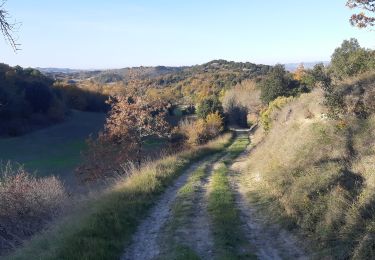
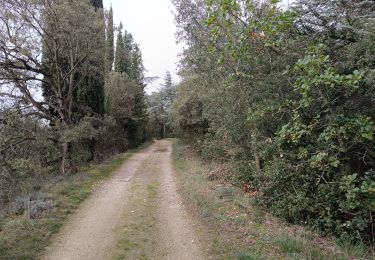
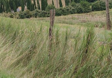
Le chemin des collines du vent passe au dessus de Laurac Le Grand, nous poursuivons jusqu’à Laurabuc, un lieu remarquablement riche pour son passé et son patrimoine puis retour sur Laurac Le Grand, village également très riche de son histoire. C'est une belle, randonnée très agréable avec son chemin de crêtes ses sentiers herbeux ses sous bois. A faire et à refaire avec plaisir.

Hoogteprofiel

Plaatsbepaling

Land:
France
Regio :
Occitanië
Departement/Provincie :
Aude
Gemeente :
Laurac
Locatie:
Unknown
Vertrek:(UTM)
416804 ; 4786587 (31T) N.

Opmerkingen

Gelieve in te loggen om een commentaar of een beoordeling achter te laten


Wandeltochten in de omgeving

Tocht Stappen Fanjeaux - Fanjeaux la hilhe - Photo
Stappen
cappelle

Stappen

Moeilijk
(1)
Fanjeaux, Occitanië, Aude, France
9,7 km | 13,2 km-effort
3h 0min
Neen
Tocht Mountainbike Villasavary - circuit 3 villasavary - Photo
Mountainbike
leroj73

Mountainbike

Medium
(1)
Villasavary, Occitanië, Aude, France
23 km | 30 km-effort
1h 43min
Ja
Tocht Stappen Laurac - Laurac Fanjeaux - Photo
Stappen
tracegps

Stappen

Zeer moeilijk
(1)
Laurac, Occitanië, Aude, France
27 km | 37 km-effort
6h 30min
Ja
Tocht Stappen Fonters-du-Razès - Boucle Saint Christol  - Photo
Stappen
Mamilaure

Stappen

Gemakkelijk
Fonters-du-Razès, Occitanië, Aude, France
12,6 km | 16,3 km-effort
2h 48min
Ja
Tocht Stappen Fanjeaux - Fanjeaux  Boucle de la Hille  - Photo
Stappen
Mamilaure

Stappen

Medium
Fanjeaux, Occitanië, Aude, France
13,1 km | 18,3 km-effort
3h 30min
Ja
Tocht Stappen Cazalrenoux - Cazalrenoux  - Photo
Stappen
Mamilaure

Stappen

Medium
(1)
Cazalrenoux, Occitanië, Aude, France
9,8 km | 13,6 km-effort
2h 57min
Ja
Tocht Mountainbike Laurabuc - boucle bb - Photo
Mountainbike
leroj73

Mountainbike

Gemakkelijk
(1)
Laurabuc, Occitanië, Aude, France
15,2 km | 19,2 km-effort
1h 15min
Ja
Tocht Stappen Fanjeaux - Chemin du Piémont Pyrénéen - de Fanjeaux à Mirepoix - Photo
Stappen
tracegps

Stappen

Moeilijk
(1)
Fanjeaux, Occitanië, Aude, France
26 km | 33 km-effort
6h 0min
Neen
Tocht Stappen Cazalrenoux - cazalrenoux - Photo
Stappen
cappelle

Stappen

Gemakkelijk
Cazalrenoux, Occitanië, Aude, France
9,5 km | 13,1 km-effort
2h 49min
Neen


Sluiten
Mijn abonnementen