![](/images/other/stat-length.png)
![Tocht Stappen Saint-Amand-les-Eaux - Mesnil, version plus longue - Photo](https://media.geolcdn.com/t/1900/400/e5ac201c-8480-46b8-81d2-a49e027ccf3b.jpg&format=pjpeg&maxdim=2)
Mesnil, version plus longue
papiou
Gebruiker
![Lengte](/images/other/stat-length.png)
Lengte
9,9 km
![Max. hoogte](https://static1.geolcdn.com/siteimages/upload/files/1508320355ic_sort_altitude_max_24dp.png)
Max. hoogte
53 m
![Positief hoogteverschil](https://static1.geolcdn.com/siteimages/upload/files/1508320355ic_sort_den_pos_24dp.png)
Positief hoogteverschil
86 m
![Km-Effort](/images/other/stat-length.png)
Km-Effort
11,1 km
![Min. hoogte](https://static1.geolcdn.com/siteimages/upload/files/1508320355ic_sort_altitude_min_24dp.png)
Min. hoogte
19 m
![Negatief hoogteverschil](https://static1.geolcdn.com/siteimages/upload/files/1508320355ic_sort_den_neg_24dp.png)
Negatief hoogteverschil
87 m
![Boucle](https://static1.geolcdn.com/siteimages/upload/files/16400158638029165_repeat_loop_refresh_sync_direction_icon.png)
Boucle
Ja
Datum van aanmaak :
2021-01-21 13:10:13.368
Laatste wijziging :
2021-01-21 16:42:57.332
![Stappen](https://static1.geolcdn.com/sitytour/trail-icons/101.png)
2h02
Moeilijkheid : Gemakkelijk
![Scan deze QR-code om de tocht te openen in de SityTrail-applicatie](https://capi.geolives.com/qq0zvz2zws4bq2lad0pu/sitytour/trails/2647211/qr.png?size=200)
Gratisgps-wandelapplicatie
Over ons
Tocht Stappen van 9,9 km beschikbaar op Hauts-de-France, Noorderdepartement, Saint-Amand-les-Eaux. Deze tocht wordt voorgesteld door papiou.
Beschrijving
rdv carrefour Mesnil et prendre dreve petit bouze jusqu'à MF Suchemont puis le coucou, rejoindre dreve d'escaupont par route macadam et aller jusqu'à dreve de la longue chasse. revenir par étoile Cernes et sangliers joueurs (BB rose)
Plaatsbepaling
Land:
France
Regio :
Hauts-de-France
Departement/Provincie :
Noorderdepartement
Gemeente :
Saint-Amand-les-Eaux
Locatie:
Unknown
Vertrek:(Dec)
Vertrek:(UTM)
534191 ; 5586837 (31U) N.
Opmerkingen
Wandeltochten in de omgeving
![Tocht Stappen Raismes - Circuit du Terril de Sabatier - Photo](https://media.geolcdn.com/t/375/260/ext.jpg?maxdim=2&url=https%3A%2F%2Fservices.sitytrail.com%2FGeolivesWS%2FDownloadMedia.ashx%3FTrailID%3D479716%26Media%3D781031eb-7ab3-4c80-8a0c-0836d5a81ce2.JPG)
![Stappen Stappen](https://static1.geolcdn.com/sitytour/trail-icons/101.png)
Circuit du Terril de Sabatier
Stappen
Gemakkelijk
(1)
Raismes,
Hauts-de-France,
Noorderdepartement,
France
![](/images/other/stat-length.png)
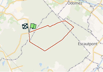
13 km | 14,9 km-effort
2h 34min
![](https://static1.geolcdn.com/siteimages/upload/files/16400158638029165_repeat_loop_refresh_sync_direction_icon.png)
Ja
![Tocht Stappen Hergnies - Entre terre et eaux - Hergnies - Photo](https://media.geolcdn.com/t/375/260/ext.jpg?maxdim=2&url=https%3A%2F%2Fservices.sitytrail.com%2FGeolivesWS%2FDownloadMedia.ashx%3FTrailID%3D111915%26Media%3D8943_6.jpg)
![Stappen Stappen](https://static1.geolcdn.com/sitytour/trail-icons/101.png)
Entre terre et eaux - Hergnies
Stappen
Moeilijk
(2)
Hergnies,
Hauts-de-France,
Noorderdepartement,
France
![](/images/other/stat-length.png)
13,2 km | 13,9 km-effort
3h 19min
![](https://static1.geolcdn.com/siteimages/upload/files/16400158638029165_repeat_loop_refresh_sync_direction_icon.png)
Ja
![Tocht Stappen Raismes - Mare à Goriaux - Photo](https://media.geolcdn.com/t/375/260/cb4184f6-3666-47fb-a89a-0644abab2b32.jpg&format=jpg&maxdim=2)
![Stappen Stappen](https://static1.geolcdn.com/sitytour/trail-icons/101.png)
Mare à Goriaux
Stappen
Medium
Raismes,
Hauts-de-France,
Noorderdepartement,
France
![](/images/other/stat-length.png)
21 km | 23 km-effort
4h 28min
![](https://static1.geolcdn.com/siteimages/upload/files/16400158638029165_repeat_loop_refresh_sync_direction_icon.png)
Ja
![Tocht Stappen Raismes - Terril du lavoir Rousseau - Photo](https://media.geolcdn.com/t/375/260/55636772-211b-4a0e-95d1-d18ad30169e0.jpg&format=jpg&maxdim=2)
![Stappen Stappen](https://static1.geolcdn.com/sitytour/trail-icons/101.png)
Terril du lavoir Rousseau
Stappen
Medium
Raismes,
Hauts-de-France,
Noorderdepartement,
France
![](/images/other/stat-length.png)
5,7 km | 7,2 km-effort
2h 7min
![](https://static1.geolcdn.com/siteimages/upload/files/16400158638029165_repeat_loop_refresh_sync_direction_icon.png)
Ja
![Tocht Stappen Saint-Amand-les-Eaux - terril vicoigne - Photo](https://media.geolcdn.com/t/375/260/d8552856-5959-4bc8-a6d2-93f721ca17ec.jpg&format=jpg&maxdim=2)
![Stappen Stappen](https://static1.geolcdn.com/sitytour/trail-icons/101.png)
terril vicoigne
Stappen
Gemakkelijk
(1)
Saint-Amand-les-Eaux,
Hauts-de-France,
Noorderdepartement,
France
![](/images/other/stat-length.png)
8,7 km | 9,7 km-effort
2h 0min
![](https://static1.geolcdn.com/siteimages/upload/files/16400158638029165_repeat_loop_refresh_sync_direction_icon.png)
Ja
![Tocht Stappen Raismes - terril du lavoir rousseau - Photo](https://media.geolcdn.com/t/375/260/2a750bf1-1f0f-4ec6-9f4d-4d916d2a14af.jpg&format=jpg&maxdim=2)
![Stappen Stappen](https://static1.geolcdn.com/sitytour/trail-icons/101.png)
terril du lavoir rousseau
Stappen
Medium
Raismes,
Hauts-de-France,
Noorderdepartement,
France
![](/images/other/stat-length.png)
7,5 km | 9,3 km-effort
2h 0min
![](https://static1.geolcdn.com/siteimages/upload/files/16400158638029165_repeat_loop_refresh_sync_direction_icon.png)
Ja
![Tocht Stappen Saint-Amand-les-Eaux - notre dame d'amour(NDA), propose par VDN - Photo](https://media.geolcdn.com/t/375/260/630cd120-0ef0-4a83-86e7-91e6331d9f35.jpg&format=jpg&maxdim=2)
![Stappen Stappen](https://static1.geolcdn.com/sitytour/trail-icons/101.png)
notre dame d'amour(NDA), propose par VDN
Stappen
Medium
Saint-Amand-les-Eaux,
Hauts-de-France,
Noorderdepartement,
France
![](/images/other/stat-length.png)
9,7 km | 10,6 km-effort
2h 16min
![](https://static1.geolcdn.com/siteimages/upload/files/16400158638029165_repeat_loop_refresh_sync_direction_icon.png)
Ja
![Tocht Stappen Raismes - variante de la course des terrils - Photo](https://media.geolcdn.com/t/375/260/f1af6116-6469-445b-a358-4f5a4f22ced7.jpg&format=jpg&maxdim=2)
![Stappen Stappen](https://static1.geolcdn.com/sitytour/trail-icons/101.png)
variante de la course des terrils
Stappen
Medium
(1)
Raismes,
Hauts-de-France,
Noorderdepartement,
France
![](/images/other/stat-length.png)
8,8 km | 10 km-effort
2h 10min
![](https://static1.geolcdn.com/siteimages/upload/files/16400158638029165_repeat_loop_refresh_sync_direction_icon.png)
Ja
![Tocht Stappen Wallers - Mare goraux - Photo](https://media.geolcdn.com/t/375/260/82eaa7c8-ae6a-4094-92a3-48d31e49731d.jpg&format=jpg&maxdim=2)
![Stappen Stappen](https://static1.geolcdn.com/sitytour/trail-icons/101.png)
Mare goraux
Stappen
Medium
Wallers,
Hauts-de-France,
Noorderdepartement,
France
![](/images/other/stat-length.png)
6,8 km | 7,5 km-effort
1h 32min
![](https://static1.geolcdn.com/siteimages/upload/files/16400158638029165_repeat_loop_refresh_sync_direction_icon.png)
Ja