![](/images/other/stat-length.png)
![Tocht Stappen Dieulouard - LA VIERGE DE BELLEVILLE - Photo](https://media.geolcdn.com/t/1900/400/92071029-0e02-4fd1-a34a-416f4acba2b2.jpg&format=pjpeg&maxdim=2)
LA VIERGE DE BELLEVILLE
jean-marie.parachini
Gebruiker
![Lengte](/images/other/stat-length.png)
![Max. hoogte](https://static1.geolcdn.com/siteimages/upload/files/1508320355ic_sort_altitude_max_24dp.png)
![Positief hoogteverschil](https://static1.geolcdn.com/siteimages/upload/files/1508320355ic_sort_den_pos_24dp.png)
![Km-Effort](/images/other/stat-length.png)
![Min. hoogte](https://static1.geolcdn.com/siteimages/upload/files/1508320355ic_sort_altitude_min_24dp.png)
![Negatief hoogteverschil](https://static1.geolcdn.com/siteimages/upload/files/1508320355ic_sort_den_neg_24dp.png)
![Boucle](https://static1.geolcdn.com/siteimages/upload/files/16400158638029165_repeat_loop_refresh_sync_direction_icon.png)
![Stappen](https://static1.geolcdn.com/sitytour/trail-icons/101.png)
3h19
Moeilijkheid : Gemakkelijk
![Scan deze QR-code om de tocht te openen in de SityTrail-applicatie](https://capi.geolives.com/qq0zvz2zws4bq2lad0pu/sitytour/trails/2646483/qr.png?size=200)
Gratisgps-wandelapplicatie
Over ons
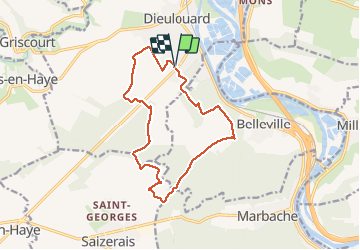
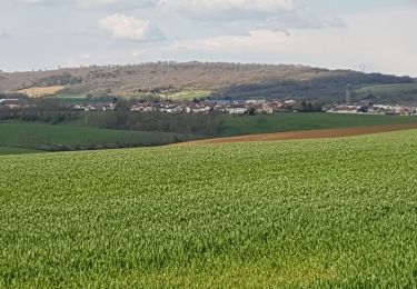
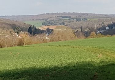
Tocht Stappen van 13,4 km beschikbaar op Grand Est, Meurthe-et-Moselle, Dieulouard. Deze tocht wordt voorgesteld door jean-marie.parachini.
Beschrijving
Parking Colruyt – traverser la route – vau du Chanot – bois de l’Epine – vierge de Belleville – vau des Coulons – le bois St. Champ – bois de neuleu** - traverser la route de Toul vers les grands Rayeux – chemin enfoncé – monter le Petit Gerbeau – parking Colruyt.
Plaatsbepaling
Opmerkingen
Wandeltochten in de omgeving
![Tocht Fiets Dieulouard - La petite Suisse Lorraine - Circuit n° 11 - Photo](https://media.geolcdn.com/t/375/260/ext.jpg?maxdim=2&url=https%3A%2F%2Fservices.sitytrail.com%2FGeolivesWS%2FDownloadMedia.ashx%3FTrailID%3D111711%26Media%3D8026_6.jpg)
![Fiets Fiets](https://static1.geolcdn.com/sitytour/trail-icons/200.png)
Fiets
![](/images/other/stat-length.png)
![](https://static1.geolcdn.com/siteimages/upload/files/16400158638029165_repeat_loop_refresh_sync_direction_icon.png)
![Tocht Te voet Sainte-Geneviève - Boucle de la Colline - Photo](https://media.geolcdn.com/t/375/260/959f6021-7f3e-47f9-9958-dc2cd4363673.jpeg&format=jpg&maxdim=2)
![Te voet Te voet](https://static1.geolcdn.com/sitytour/trail-icons/100.png)
Te voet
![](/images/other/stat-length.png)
![](https://static1.geolcdn.com/siteimages/upload/files/16400158638029165_repeat_loop_refresh_sync_direction_icon.png)
![Tocht Mountainbike Millery - Rando VTT Millery-Autreville Tous unis contre le cancer 2024 - Photo](https://media.geolcdn.com/t/375/260/ext.jpg?maxdim=2&url=https%3A%2F%2Fstatic1.geolcdn.com%2Fsiteimages%2Fupload%2Ffiles%2F1524743154velo.jpg)
![Mountainbike Mountainbike](https://static1.geolcdn.com/sitytour/trail-icons/202.png)
Mountainbike
![](/images/other/stat-length.png)
![](https://static1.geolcdn.com/siteimages/upload/files/16400158638029165_repeat_loop_refresh_sync_direction_icon.png)
![Tocht Mountainbike Millery - Rando VTT 25km Millery-Autreville Tous unis contre le cancer 2022 - Photo](https://media.geolcdn.com/t/375/260/ext.jpg?maxdim=2&url=https%3A%2F%2Fstatic1.geolcdn.com%2Fsiteimages%2Fupload%2Ffiles%2F1524743154velo.jpg)
![Mountainbike Mountainbike](https://static1.geolcdn.com/sitytour/trail-icons/202.png)
Mountainbike
![](/images/other/stat-length.png)
![](https://static1.geolcdn.com/siteimages/upload/files/16400158638029165_repeat_loop_refresh_sync_direction_icon.png)
![Tocht Te voet Marbache - Circuit de la Vierge de Belleville - Photo](https://media.geolcdn.com/t/375/260/ed731c2b-3434-456a-907f-b6c3a07468bd.jpeg&format=jpg&maxdim=2)
![Te voet Te voet](https://static1.geolcdn.com/sitytour/trail-icons/100.png)
Te voet
![](/images/other/stat-length.png)
![](https://static1.geolcdn.com/siteimages/upload/files/16400158638029165_repeat_loop_refresh_sync_direction_icon.png)
![Tocht Stappen Saizerais - SAIZERAIS - LES CORNOUILLERS ET LES HOSPICES - Photo](https://media.geolcdn.com/t/375/260/54e8a510-a902-4c19-acc7-c2168d7e5db6.jpg&format=jpg&maxdim=2)
![Stappen Stappen](https://static1.geolcdn.com/sitytour/trail-icons/101.png)
Stappen
![](/images/other/stat-length.png)
![](https://static1.geolcdn.com/siteimages/upload/files/16400158638029165_repeat_loop_refresh_sync_direction_icon.png)
![Tocht Stappen Millery - MILLERY - LA CÔTE DE CREUX - Photo](https://media.geolcdn.com/t/375/260/8b9217e5-d22e-48bb-adf4-7d0e099a6dcb.jpg&format=jpg&maxdim=2)
![Stappen Stappen](https://static1.geolcdn.com/sitytour/trail-icons/101.png)
Stappen
![](/images/other/stat-length.png)
![](https://static1.geolcdn.com/siteimages/upload/files/16400158638029165_repeat_loop_refresh_sync_direction_icon.png)
![Tocht Stappen Dieulouard - DIEULOUARD - VERS BELLEVILLE ET SAIZERAIS - Photo](https://media.geolcdn.com/t/375/260/c2018011-1bfa-47ce-b819-34efd5861339.jpg&format=jpg&maxdim=2)
![Stappen Stappen](https://static1.geolcdn.com/sitytour/trail-icons/101.png)
Stappen
![](/images/other/stat-length.png)
![](https://static1.geolcdn.com/siteimages/upload/files/16400158638029165_repeat_loop_refresh_sync_direction_icon.png)
![Tocht Stappen Marbache - MARBACHE - LA TARTE - Photo](https://media.geolcdn.com/t/375/260/c7ab0792-3c24-41a0-b793-e6399a96c4a4.jpg&format=jpg&maxdim=2)
![Stappen Stappen](https://static1.geolcdn.com/sitytour/trail-icons/101.png)
Stappen
![](/images/other/stat-length.png)
![](https://static1.geolcdn.com/siteimages/upload/files/16400158638029165_repeat_loop_refresh_sync_direction_icon.png)