![](/images/other/stat-length.png)
![Tocht Stappen Manhay - manhay - Photo](https://media.geolcdn.com/t/1900/400/ext.pjpeg?maxdim=2&url=https%3A%2F%2Fstatic1.geolcdn.com%2Fsiteimages%2Fupload%2Ffiles%2F1553511878bg_sport_marche.png)
manhay
c.watrin
Gebruiker
![Lengte](/images/other/stat-length.png)
Lengte
8,5 km
![Max. hoogte](https://static1.geolcdn.com/siteimages/upload/files/1508320355ic_sort_altitude_max_24dp.png)
Max. hoogte
533 m
![Positief hoogteverschil](https://static1.geolcdn.com/siteimages/upload/files/1508320355ic_sort_den_pos_24dp.png)
Positief hoogteverschil
204 m
![Km-Effort](/images/other/stat-length.png)
Km-Effort
11,2 km
![Min. hoogte](https://static1.geolcdn.com/siteimages/upload/files/1508320355ic_sort_altitude_min_24dp.png)
Min. hoogte
407 m
![Negatief hoogteverschil](https://static1.geolcdn.com/siteimages/upload/files/1508320355ic_sort_den_neg_24dp.png)
Negatief hoogteverschil
204 m
![Boucle](https://static1.geolcdn.com/siteimages/upload/files/16400158638029165_repeat_loop_refresh_sync_direction_icon.png)
Boucle
Ja
Datum van aanmaak :
2021-01-15 15:57:37.449
Laatste wijziging :
2021-01-15 16:37:52.287
![Stappen](https://static1.geolcdn.com/sitytour/trail-icons/101.png)
--
Moeilijkheid : Onbekend
![Scan deze QR-code om de tocht te openen in de SityTrail-applicatie](https://capi.geolives.com/qq0zvz2zws4bq2lad0pu/sitytour/trails/2641381/qr.png?size=200)
Gratisgps-wandelapplicatie
Over ons
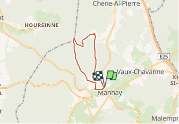
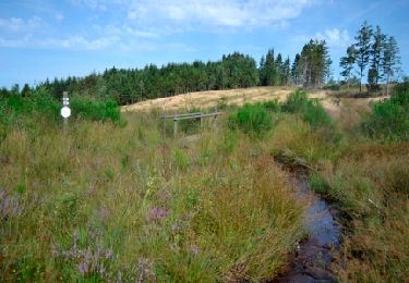
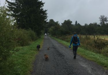
Tocht Stappen van 8,5 km beschikbaar op Wallonië, Luxemburg, Manhay. Deze tocht wordt voorgesteld door c.watrin.
Beschrijving
Parking : près du marchand de bois, au coin de la rue du Vicinal et sur les Monts (à hauteur de la station d'essence....
Rue du Vicinal 3
Manhay
Plaatsbepaling
Land:
Belgium
Regio :
Wallonië
Departement/Provincie :
Luxemburg
Gemeente :
Manhay
Locatie:
Vaux-Chavanne
Vertrek:(Dec)
Vertrek:(UTM)
690367 ; 5574919 (31U) N.
Opmerkingen
Wandeltochten in de omgeving
![Tocht Stappen Érezée - Hoursinne. Natura 2000, des sites qui valent le détour. Lx 1 - Photo](https://media.geolcdn.com/t/375/260/ext.jpg?maxdim=2&url=https%3A%2F%2Fservices.sitytrail.com%2FGeolivesWS%2FDownloadMedia.ashx%3FTrailID%3D142589%26Media%3Df0338fc2-a78f-45f3-92a6-ccf3ccce12cc.JPG)
![Stappen Stappen](https://static1.geolcdn.com/sitytour/trail-icons/101.png)
Hoursinne. Natura 2000, des sites qui valent le détour. Lx 1
Stappen
Moeilijk
(9)
Érezée,
Wallonië,
Luxemburg,
Belgium
![](/images/other/stat-length.png)
8,1 km | 10,8 km-effort
2h 19min
![](https://static1.geolcdn.com/siteimages/upload/files/16400158638029165_repeat_loop_refresh_sync_direction_icon.png)
Ja
![Tocht Stappen Manhay - 2021-06-30_10h25m20_Cirkwi-PLANTISSE_(Commune_de_MANHAY) - Photo](https://media.geolcdn.com/t/375/260/b60c879b-a532-47f8-9457-412a61021edd.jpg&format=jpg&maxdim=2)
![Stappen Stappen](https://static1.geolcdn.com/sitytour/trail-icons/101.png)
2021-06-30_10h25m20_Cirkwi-PLANTISSE_(Commune_de_MANHAY)
Stappen
Gemakkelijk
(3)
Manhay,
Wallonië,
Luxemburg,
Belgium
![](/images/other/stat-length.png)
12,8 km | 16,7 km-effort
3h 47min
![](https://static1.geolcdn.com/siteimages/upload/files/16400158638029165_repeat_loop_refresh_sync_direction_icon.png)
Ja
![Tocht Stappen Vielsalm - baraque fraiture . rocher du diable . vallée de la géhe . la fondroule . Thier de la forge . las des cignes grognons . fraiture . baraque fraiture - Photo](https://media.geolcdn.com/t/375/260/1a4faef5-7559-417e-99e4-27ecaefd718d.jpg&format=jpg&maxdim=2)
![Stappen Stappen](https://static1.geolcdn.com/sitytour/trail-icons/101.png)
baraque fraiture . rocher du diable . vallée de la géhe . la fondroule . Thi...
Stappen
Heel gemakkelijk
(4)
Vielsalm,
Wallonië,
Luxemburg,
Belgium
![](/images/other/stat-length.png)
12,1 km | 16,5 km-effort
3h 24min
![](https://static1.geolcdn.com/siteimages/upload/files/16400158638029165_repeat_loop_refresh_sync_direction_icon.png)
Ja
![Stappen Stappen](https://static1.geolcdn.com/sitytour/trail-icons/101.png)
RB-Lu-32_Malempré_Boucle-1
Stappen
Medium
(1)
Manhay,
Wallonië,
Luxemburg,
Belgium
![](/images/other/stat-length.png)
23 km | 30 km-effort
6h 18min
![](https://static1.geolcdn.com/siteimages/upload/files/16400158638029165_repeat_loop_refresh_sync_direction_icon.png)
Ja
![Stappen Stappen](https://static1.geolcdn.com/sitytour/trail-icons/101.png)
RB-Lu-32_Malempré
Stappen
Zeer moeilijk
(2)
Manhay,
Wallonië,
Luxemburg,
Belgium
![](/images/other/stat-length.png)
22 km | 29 km-effort
6h 29min
![](https://static1.geolcdn.com/siteimages/upload/files/16400158638029165_repeat_loop_refresh_sync_direction_icon.png)
Ja
![Tocht Stappen Manhay - Odeigne, Natura 2000 - Des sites qui valent le détour. Lx10 - Photo](https://media.geolcdn.com/t/375/260/ext.jpg?maxdim=2&url=https%3A%2F%2Fservices.sitytrail.com%2FGeolivesWS%2FDownloadMedia.ashx%3FTrailID%3D181914%26Media%3D2ebe3571-d68b-4ddb-98f1-22a093149033.jpg)
![Stappen Stappen](https://static1.geolcdn.com/sitytour/trail-icons/101.png)
Odeigne, Natura 2000 - Des sites qui valent le détour. Lx10
Stappen
Gemakkelijk
(5)
Manhay,
Wallonië,
Luxemburg,
Belgium
![](/images/other/stat-length.png)
8,8 km | 10,9 km-effort
2h 23min
![](https://static1.geolcdn.com/siteimages/upload/files/16400158638029165_repeat_loop_refresh_sync_direction_icon.png)
Ja
![Tocht Stappen Érezée - Hoursine-Hoursine 12kms - Photo](https://media.geolcdn.com/t/375/260/c996774c-2642-4a86-94e0-eab3c7bcc053.jpg&format=jpg&maxdim=2)
![Stappen Stappen](https://static1.geolcdn.com/sitytour/trail-icons/101.png)
Hoursine-Hoursine 12kms
Stappen
Moeilijk
(1)
Érezée,
Wallonië,
Luxemburg,
Belgium
![](/images/other/stat-length.png)
12,5 km | 17,1 km-effort
3h 37min
![](https://static1.geolcdn.com/siteimages/upload/files/16400158638029165_repeat_loop_refresh_sync_direction_icon.png)
Ja
![Tocht Stappen Manhay - Derieux - Photo](https://media.geolcdn.com/t/375/260/ext.jpg?maxdim=2&url=https%3A%2F%2Fservices.sitytrail.com%2FGeolivesWS%2FDownloadMedia.ashx%3FTrailID%3D203687%26Media%3D881bc979-a407-486b-a86a-96a8c5851a06.jpg)
![Stappen Stappen](https://static1.geolcdn.com/sitytour/trail-icons/101.png)
Derieux
Stappen
Heel gemakkelijk
(4)
Manhay,
Wallonië,
Luxemburg,
Belgium
![](/images/other/stat-length.png)
10,1 km | 12,8 km-effort
2h 44min
![](https://static1.geolcdn.com/siteimages/upload/files/16400158638029165_repeat_loop_refresh_sync_direction_icon.png)
Ja
![Tocht Stappen Manhay - Adeps Manhay 2019 - Photo](https://media.geolcdn.com/t/375/260/973befab-8fc0-4d15-a847-1005c7bc733e.jpg&format=jpg&maxdim=2)
![Stappen Stappen](https://static1.geolcdn.com/sitytour/trail-icons/101.png)
Adeps Manhay 2019
Stappen
(1)
Manhay,
Wallonië,
Luxemburg,
Belgium
![](/images/other/stat-length.png)
10,2 km | 13,3 km-effort
1h 58min
![](https://static1.geolcdn.com/siteimages/upload/files/16400158638029165_repeat_loop_refresh_sync_direction_icon.png)
Ja