![](/images/other/stat-length.png)
![Tocht Noords wandelen Perwijs - Le Circuit des Fermes - Photo](https://media.geolcdn.com/t/1900/400/ext.pjpeg?maxdim=2&url=https%3A%2F%2Fstatic1.geolcdn.com%2Fsiteimages%2Fupload%2Ffiles%2F1545311037marcheuse_200dpi.jpg)
Le Circuit des Fermes
denissculier
Gebruiker
![Lengte](/images/other/stat-length.png)
![Max. hoogte](https://static1.geolcdn.com/siteimages/upload/files/1508320355ic_sort_altitude_max_24dp.png)
![Positief hoogteverschil](https://static1.geolcdn.com/siteimages/upload/files/1508320355ic_sort_den_pos_24dp.png)
![Km-Effort](/images/other/stat-length.png)
![Min. hoogte](https://static1.geolcdn.com/siteimages/upload/files/1508320355ic_sort_altitude_min_24dp.png)
![Negatief hoogteverschil](https://static1.geolcdn.com/siteimages/upload/files/1508320355ic_sort_den_neg_24dp.png)
![Boucle](https://static1.geolcdn.com/siteimages/upload/files/16400158638029165_repeat_loop_refresh_sync_direction_icon.png)
![Noords wandelen](https://static1.geolcdn.com/sitytour/trail-icons/102.png)
1h05
Moeilijkheid : Gemakkelijk
![Scan deze QR-code om de tocht te openen in de SityTrail-applicatie](https://capi.geolives.com/qq0zvz2zws4bq2lad0pu/sitytour/trails/2624425/qr.png?size=200)
Gratisgps-wandelapplicatie
Over ons
Tocht Noords wandelen van 4,6 km beschikbaar op Wallonië, Waals-Brabant, Perwijs. Deze tocht wordt voorgesteld door denissculier.
Beschrijving
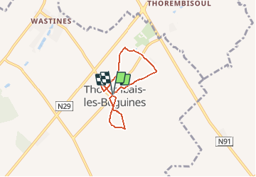
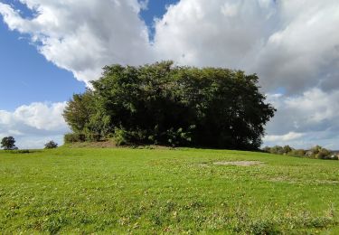
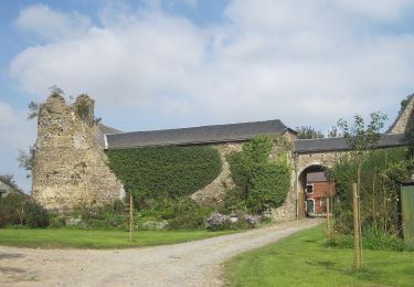
Thorembais-les-Béguines est l’un des villages les plus pittoresques de l’entité de Perwez. Témoins d’une intense activité agricole, plusieurs majestueuses fermes brabançonnes en quadrilatère, remarquablement rénovées et entretenues, caractérisent le paysage rural. La présente balade, assez courte (environ 4 km), sillonne les paisibles voiries du village en rendant hommage aux principaux édifices agricoles. Comme son voisin de Thorembais-Saint-Trond, Thorembais-les-Béguines tient son nom de la rivière Thorembais. Quant aux « Béguines », elles font référence à l’existence d’un ancien béguinage fondé par Sainte Ode au XIIIème siècle. Jadis, le village se dénommait Thorembais-Saint-Martin.
Plaatsbepaling
Opmerkingen
Wandeltochten in de omgeving
![Te voet Te voet](https://static1.geolcdn.com/sitytour/trail-icons/100.png)
Te voet
![](/images/other/stat-length.png)
![](https://static1.geolcdn.com/siteimages/upload/files/16400158638029165_repeat_loop_refresh_sync_direction_icon.png)
![Tocht Stappen Incourt - Ballade au soleil - Photo](https://media.geolcdn.com/t/375/260/ext.jpg?maxdim=2&url=https%3A%2F%2Fservices.sitytrail.com%2FGeolivesWS%2FDownloadMedia.ashx%3FTrailID%3D407894%26Media%3D3656b3ca-7464-489a-8f3d-1e57b2f10ace.jpg)
![Stappen Stappen](https://static1.geolcdn.com/sitytour/trail-icons/101.png)
Stappen
![](/images/other/stat-length.png)
![](https://static1.geolcdn.com/siteimages/upload/files/16400158638029165_repeat_loop_refresh_sync_direction_icon.png)
![Tocht Stappen Incourt - boucle Sart Risbart 27km - Photo](https://media.geolcdn.com/t/375/260/7ae00361-326e-49c8-8902-8fa43c4f2ac3.jpg&format=jpg&maxdim=2)
![Stappen Stappen](https://static1.geolcdn.com/sitytour/trail-icons/101.png)
Stappen
![](/images/other/stat-length.png)
![](https://static1.geolcdn.com/siteimages/upload/files/16400158638029165_repeat_loop_refresh_sync_direction_icon.png)
![Tocht Stappen Perwijs - #230102 - Perwez > Ponceau, dont 4 km du GRP127 - Photo](https://media.geolcdn.com/t/375/260/ext.jpg?maxdim=2&url=https%3A%2F%2Fstatic1.geolcdn.com%2Fsiteimages%2Fupload%2Ffiles%2F1553511878bg_sport_marche.png)
![Stappen Stappen](https://static1.geolcdn.com/sitytour/trail-icons/101.png)
Stappen
![](/images/other/stat-length.png)
![](https://static1.geolcdn.com/siteimages/upload/files/16400158638029165_repeat_loop_refresh_sync_direction_icon.png)
![Tocht Stappen Incourt - Promenade du Tumulus (6,1km) - Photo](https://media.geolcdn.com/t/375/260/42b094d1-405f-40a3-978f-996b68225655.jpg&format=jpg&maxdim=2)
![Stappen Stappen](https://static1.geolcdn.com/sitytour/trail-icons/101.png)
Stappen
![](/images/other/stat-length.png)
![](https://static1.geolcdn.com/siteimages/upload/files/16400158638029165_repeat_loop_refresh_sync_direction_icon.png)
![Tocht Stappen Incourt - Promenade du moulin - Photo](https://media.geolcdn.com/t/375/260/087f0754-2134-48a0-a8d6-263f8bb77c35.jpg&format=jpg&maxdim=2)
![Stappen Stappen](https://static1.geolcdn.com/sitytour/trail-icons/101.png)
Stappen
![](/images/other/stat-length.png)
![](https://static1.geolcdn.com/siteimages/upload/files/16400158638029165_repeat_loop_refresh_sync_direction_icon.png)
![Tocht Te voet Geldenaken - Promenade de la Ramée - Photo](https://media.geolcdn.com/t/375/260/2884b106-ded9-4c41-90fb-2fb633d6b660.jpeg&format=jpg&maxdim=2)
![Te voet Te voet](https://static1.geolcdn.com/sitytour/trail-icons/100.png)
Te voet
![](/images/other/stat-length.png)
![](https://static1.geolcdn.com/siteimages/upload/files/16400158638029165_repeat_loop_refresh_sync_direction_icon.png)
![Tocht Te voet Geldenaken - Promenade Tienne Stricheaux - Photo](https://media.geolcdn.com/t/375/260/6a1cf292-89c7-4f5d-ba1e-8d0767721f41.jpeg&format=jpg&maxdim=2)
![Te voet Te voet](https://static1.geolcdn.com/sitytour/trail-icons/100.png)
Te voet
![](/images/other/stat-length.png)
![](https://static1.geolcdn.com/siteimages/upload/files/16400158638029165_repeat_loop_refresh_sync_direction_icon.png)
![Tocht Te voet Incourt - Promenade du Moulin - Photo](https://media.geolcdn.com/t/375/260/e591d988-5435-4454-ab9d-f70c8657ac68.jpeg&format=jpg&maxdim=2)
![Te voet Te voet](https://static1.geolcdn.com/sitytour/trail-icons/100.png)
Te voet
![](/images/other/stat-length.png)
![](https://static1.geolcdn.com/siteimages/upload/files/16400158638029165_repeat_loop_refresh_sync_direction_icon.png)