![](/images/other/stat-length.png)
![Tocht Stappen Duranus - Ruines du Village de Rocca Sparviera au départ d'Engarvin - Photo](https://media.geolcdn.com/t/1900/400/ext.pjpeg?maxdim=2&url=https%3A%2F%2Fstatic1.geolcdn.com%2Fsiteimages%2Fupload%2Ffiles%2F1553511878bg_sport_marche.png)
Ruines du Village de Rocca Sparviera au départ d'Engarvin
clarambre
Gebruiker
![Lengte](/images/other/stat-length.png)
![Max. hoogte](https://static1.geolcdn.com/siteimages/upload/files/1508320355ic_sort_altitude_max_24dp.png)
![Positief hoogteverschil](https://static1.geolcdn.com/siteimages/upload/files/1508320355ic_sort_den_pos_24dp.png)
![Km-Effort](/images/other/stat-length.png)
![Min. hoogte](https://static1.geolcdn.com/siteimages/upload/files/1508320355ic_sort_altitude_min_24dp.png)
![Negatief hoogteverschil](https://static1.geolcdn.com/siteimages/upload/files/1508320355ic_sort_den_neg_24dp.png)
![Boucle](https://static1.geolcdn.com/siteimages/upload/files/16400158638029165_repeat_loop_refresh_sync_direction_icon.png)
![Stappen](https://static1.geolcdn.com/sitytour/trail-icons/101.png)
3h00
Moeilijkheid : Medium
![Scan deze QR-code om de tocht te openen in de SityTrail-applicatie](https://capi.geolives.com/qq0zvz2zws4bq2lad0pu/sitytour/trails/2620020/qr.png?size=200)
Gratisgps-wandelapplicatie
Over ons
Tocht Stappen van 6,9 km beschikbaar op Provence-Alpes-Côte d'Azur, Alpes-Maritimes, Duranus. Deze tocht wordt voorgesteld door clarambre.
Beschrijving
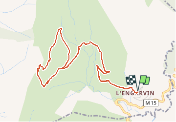
Randonnée de 7 km (12 km en effort) Dénivelé de 380 m
Engarvin à 722 m - Au max 1096 m
Départ : Balise 463, dans le hameau de l'Engarvin
De la balise 463, passer devant le musée Figas et traverser l'Engarvin. Le large chemin est facile à marcher et l'on visualise dès le début de la randonnée les étapes de celle-ci : le col St Michel, bien dessiné, la chapelle St Michel, accrochée au rocher et les ruines du village de Rocca Sparviera sur la droite. Suivre le chemin jusqu'au col St Michel.
Au col, la balise 443 indique le chemin à prendre pour arriver à la chapelle et au village. Le sentier grimpe franchement dans la roche (progression sans difficulté technique) en faisant de nombreux lacets.
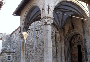
On atteint alors la chapelle St Michel puis, juste après, le village de Rocca Sparviera.
Ne pas s'aventurer dans les ruines car, fragilisées par le temps, leur équilibre est instable.
A la sortie du village, on arrive devant une bifurcation (une grosse pierre indique une flèche qui monte et l'autre qui descend) : prendre le chemin qui descend en douceur en direction de l'Engarvin. A partir de là, il n'y a plus de balisage jusqu'au point où l'on retrouve le chemin de l'aller, mais le chemin est plutôt bien marqué et il y a peu de risque de se perdre.
Une fois cette bifurcation passée, on traverse alors les anciennes restanques du village. On se dirige vers une petite maison abandonnée (voir photo). Juste devant celle-ci, le chemin fait un virage franc en sens inverse jusqu'à rejoindre le chemin de l'aller.
Reprendre le chemin de l'aller et redescendre à l'Engarvin.
Balisage bien marqué : jaune, de l'Engarvin à Rocca Sparviera. A la sortie du village, le chemin n'est plus balisé mais bien tracé.
Plaatsbepaling
Opmerkingen
Wandeltochten in de omgeving
![Tocht Stappen Utelle - Le Brec d'Utelle 1604m 19-04-22 - Photo](https://media.geolcdn.com/t/375/260/f3263017-78d2-4ab0-b769-f83aa3feee5d.jpg&format=jpg&maxdim=2)
![Stappen Stappen](https://static1.geolcdn.com/sitytour/trail-icons/101.png)
Stappen
![](/images/other/stat-length.png)
![](https://static1.geolcdn.com/siteimages/upload/files/16400158638029165_repeat_loop_refresh_sync_direction_icon.png)
![Tocht Te voet Lucéram - Circuit du Grand Braus - Photo](https://media.geolcdn.com/t/375/260/4bf0d9dd-6921-4e02-9a25-877c427da130.jpeg&format=jpg&maxdim=2)
![Te voet Te voet](https://static1.geolcdn.com/sitytour/trail-icons/100.png)
Te voet
![](/images/other/stat-length.png)
![](https://static1.geolcdn.com/siteimages/upload/files/16400158638029165_repeat_loop_refresh_sync_direction_icon.png)
![Tocht Te voet Coaraze - Rocca Sparvièra - Photo](https://media.geolcdn.com/t/375/260/b70c2ec2-277e-4b66-a927-a7ae11b9ea3a.jpeg&format=jpg&maxdim=2)
![Te voet Te voet](https://static1.geolcdn.com/sitytour/trail-icons/100.png)
Te voet
![](/images/other/stat-length.png)
![](https://static1.geolcdn.com/siteimages/upload/files/16400158638029165_repeat_loop_refresh_sync_direction_icon.png)
![Tocht Stappen Duranus - Rocca Sparviera Rocca Siera - Photo](https://media.geolcdn.com/t/375/260/cfa7ac61-c812-43a1-a04c-577e01c4a8ee.jpg&format=jpg&maxdim=2)
![Stappen Stappen](https://static1.geolcdn.com/sitytour/trail-icons/101.png)
Stappen
![](/images/other/stat-length.png)
![](https://static1.geolcdn.com/siteimages/upload/files/16400158638029165_repeat_loop_refresh_sync_direction_icon.png)
![Tocht Stappen Coaraze - Rocca Spavierra - Photo](https://media.geolcdn.com/t/375/260/ext.jpg?maxdim=2&url=https%3A%2F%2Fstatic1.geolcdn.com%2Fsiteimages%2Fupload%2Ffiles%2F1553511878bg_sport_marche.png)
![Stappen Stappen](https://static1.geolcdn.com/sitytour/trail-icons/101.png)
Stappen
![](/images/other/stat-length.png)
![](https://static1.geolcdn.com/siteimages/upload/files/16400158638029165_repeat_loop_refresh_sync_direction_icon.png)
![Tocht Stappen Utelle - Utelle, Brec d'Utelle - Photo](https://media.geolcdn.com/t/375/260/7d826307-5252-4f94-914a-8eefe923eff9.jpg&format=jpg&maxdim=2)
![Stappen Stappen](https://static1.geolcdn.com/sitytour/trail-icons/101.png)
Stappen
![](/images/other/stat-length.png)
![](https://static1.geolcdn.com/siteimages/upload/files/16400158638029165_repeat_loop_refresh_sync_direction_icon.png)
![Tocht Stappen Levens - Crête du Férion 1412m 17-04-22 - Photo](https://media.geolcdn.com/t/375/260/d630ef2c-0149-421b-9b71-c0805c57034c.jpg&format=jpg&maxdim=2)
![Stappen Stappen](https://static1.geolcdn.com/sitytour/trail-icons/101.png)
Stappen
![](/images/other/stat-length.png)
![](https://static1.geolcdn.com/siteimages/upload/files/16400158638029165_repeat_loop_refresh_sync_direction_icon.png)
![Tocht Te voet Levens - Crête du Férion - Photo](https://media.geolcdn.com/t/375/260/d2999666-b0d9-4a97-b6d4-103e7aa801ec.jpeg&format=jpg&maxdim=2)
![Te voet Te voet](https://static1.geolcdn.com/sitytour/trail-icons/100.png)
Te voet
![](/images/other/stat-length.png)
![](https://static1.geolcdn.com/siteimages/upload/files/16400158638029165_repeat_loop_refresh_sync_direction_icon.png)
![Tocht Te voet Utelle - Brec d'Utelle - Photo](https://media.geolcdn.com/t/375/260/fca2a9ca-c206-4e1f-8947-7d439ea79496.jpeg&format=jpg&maxdim=2)
![Te voet Te voet](https://static1.geolcdn.com/sitytour/trail-icons/100.png)
Te voet
![](/images/other/stat-length.png)
![](https://static1.geolcdn.com/siteimages/upload/files/16400158638029165_repeat_loop_refresh_sync_direction_icon.png)