![](/images/other/stat-length.png)
![Tocht Stappen Turckheim - Turckheim Trois épis AR - Photo](https://media.geolcdn.com/t/1900/400/4491100c-ed84-4663-8e63-d39d6a7e8da4.jpg&format=pjpeg&maxdim=2)
Turckheim Trois épis AR
zazie
Gebruiker
![Lengte](/images/other/stat-length.png)
Lengte
8,4 km
![Max. hoogte](https://static1.geolcdn.com/siteimages/upload/files/1508320355ic_sort_altitude_max_24dp.png)
Max. hoogte
609 m
![Positief hoogteverschil](https://static1.geolcdn.com/siteimages/upload/files/1508320355ic_sort_den_pos_24dp.png)
Positief hoogteverschil
347 m
![Km-Effort](/images/other/stat-length.png)
Km-Effort
13 km
![Min. hoogte](https://static1.geolcdn.com/siteimages/upload/files/1508320355ic_sort_altitude_min_24dp.png)
Min. hoogte
262 m
![Negatief hoogteverschil](https://static1.geolcdn.com/siteimages/upload/files/1508320355ic_sort_den_neg_24dp.png)
Negatief hoogteverschil
351 m
![Boucle](https://static1.geolcdn.com/siteimages/upload/files/16400158638029165_repeat_loop_refresh_sync_direction_icon.png)
Boucle
Ja
Datum van aanmaak :
2020-12-12 14:13:25.54
Laatste wijziging :
2020-12-12 16:01:35.618
![Stappen](https://static1.geolcdn.com/sitytour/trail-icons/101.png)
1h36
Moeilijkheid : Medium
![Scan deze QR-code om de tocht te openen in de SityTrail-applicatie](https://capi.geolives.com/qq0zvz2zws4bq2lad0pu/sitytour/trails/2617653/qr.png?size=200)
Gratisgps-wandelapplicatie
Over ons
Tocht Stappen van 8,4 km beschikbaar op Grand Est, Haut-Rhin, Turckheim. Deze tocht wordt voorgesteld door zazie.
Beschrijving
Chemins humides pour la descente.
Dénivelé soutenu.
Sous bois, peu de vue sur la vallée de Munster.
Beaucoup de cailloux désolidarisés des sentiers.
Plaatsbepaling
Land:
France
Regio :
Grand Est
Departement/Provincie :
Haut-Rhin
Gemeente :
Turckheim
Locatie:
Unknown
Vertrek:(Dec)
Vertrek:(UTM)
370830 ; 5327535 (32U) N.
Opmerkingen
Wandeltochten in de omgeving
![Tocht Stappen Wettolsheim - 4 châteaux Wettolsheim Husseren - Photo](https://media.geolcdn.com/t/375/260/3d38d7b6-fe96-472e-849b-8dfa9ade163e.jpg&format=jpg&maxdim=2)
![Stappen Stappen](https://static1.geolcdn.com/sitytour/trail-icons/101.png)
4 châteaux Wettolsheim Husseren
Stappen
Medium
(1)
Wettolsheim,
Grand Est,
Haut-Rhin,
France
![](/images/other/stat-length.png)
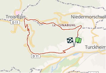
11,7 km | 17,7 km-effort
4h 28min
![](https://static1.geolcdn.com/siteimages/upload/files/16400158638029165_repeat_loop_refresh_sync_direction_icon.png)
Neen
![Tocht Stappen Ammerschwihr - D'Ammerschwihr aux Trois Epis - Photo](https://media.geolcdn.com/t/375/260/ext.jpg?maxdim=2&url=https%3A%2F%2Fservices.sitytrail.com%2FGeolivesWS%2FDownloadMedia.ashx%3FTrailID%3D404804%26Media%3Dfix__20150406154748.jpg)
![Stappen Stappen](https://static1.geolcdn.com/sitytour/trail-icons/101.png)
D'Ammerschwihr aux Trois Epis
Stappen
Moeilijk
(1)
Ammerschwihr,
Grand Est,
Haut-Rhin,
France
![](/images/other/stat-length.png)
17,1 km | 25 km-effort
5h 35min
![](https://static1.geolcdn.com/siteimages/upload/files/16400158638029165_repeat_loop_refresh_sync_direction_icon.png)
Ja
![Tocht Stappen Ammerschwihr - Trois Épis le rocher du corbeau - Photo](https://media.geolcdn.com/t/375/260/dbdb5766-f574-4a80-9cd8-371c84f0061c.jpg&format=jpg&maxdim=2)
![Stappen Stappen](https://static1.geolcdn.com/sitytour/trail-icons/101.png)
Trois Épis le rocher du corbeau
Stappen
Gemakkelijk
(2)
Ammerschwihr,
Grand Est,
Haut-Rhin,
France
![](/images/other/stat-length.png)
4,4 km | 5,7 km-effort
59min
![](https://static1.geolcdn.com/siteimages/upload/files/16400158638029165_repeat_loop_refresh_sync_direction_icon.png)
Ja
![Tocht Stappen Eguisheim - suuntoapp-Hiking-2023-12-29T09-05-16Z - Photo](https://media.geolcdn.com/t/375/260/dcbc603a-6326-4148-957e-2ff1d984719d.jpg&format=jpg&maxdim=2)
![Stappen Stappen](https://static1.geolcdn.com/sitytour/trail-icons/101.png)
suuntoapp-Hiking-2023-12-29T09-05-16Z
Stappen
Medium
Eguisheim,
Grand Est,
Haut-Rhin,
France
![](/images/other/stat-length.png)
22 km | 32 km-effort
7h 16min
![](https://static1.geolcdn.com/siteimages/upload/files/16400158638029165_repeat_loop_refresh_sync_direction_icon.png)
Ja
![Tocht Stappen Wintzenheim - Boucle de la fontaine de la dame - Photo](https://media.geolcdn.com/t/375/260/ee79f3ee-48dc-4e78-8e39-2ea9fd8c2e7b.jpg&format=jpg&maxdim=2)
![Stappen Stappen](https://static1.geolcdn.com/sitytour/trail-icons/101.png)
Boucle de la fontaine de la dame
Stappen
Medium
Wintzenheim,
Grand Est,
Haut-Rhin,
France
![](/images/other/stat-length.png)
7,9 km | 12,6 km-effort
2h 0min
![](https://static1.geolcdn.com/siteimages/upload/files/16400158638029165_repeat_loop_refresh_sync_direction_icon.png)
Ja
![Tocht Paardrijden Kaysersberg-Vignoble - 000004 - Photo](https://media.geolcdn.com/t/375/260/fc80041c-b401-476e-a019-02f21cb51a95.jpg&format=jpg&maxdim=2)
![Paardrijden Paardrijden](https://static1.geolcdn.com/sitytour/trail-icons/301.png)
000004
Paardrijden
Zeer moeilijk
Kaysersberg-Vignoble,
Grand Est,
Haut-Rhin,
France
![](/images/other/stat-length.png)
32 km | 45 km-effort
5h 55min
![](https://static1.geolcdn.com/siteimages/upload/files/16400158638029165_repeat_loop_refresh_sync_direction_icon.png)
Ja
![Tocht Mountainbike Wintzenheim - Wintzenheim - Le Stauffen - Col de Marbach - Soultzbach - Photo](https://media.geolcdn.com/t/375/260/ext.jpg?maxdim=2&url=https%3A%2F%2Fstatic1.geolcdn.com%2Fsiteimages%2Fupload%2Ffiles%2F1524743154velo.jpg)
![Mountainbike Mountainbike](https://static1.geolcdn.com/sitytour/trail-icons/202.png)
Wintzenheim - Le Stauffen - Col de Marbach - Soultzbach
Mountainbike
Medium
(1)
Wintzenheim,
Grand Est,
Haut-Rhin,
France
![](/images/other/stat-length.png)
23 km | 31 km-effort
2h 4min
![](https://static1.geolcdn.com/siteimages/upload/files/16400158638029165_repeat_loop_refresh_sync_direction_icon.png)
Ja
![Tocht Stappen Wintzenheim - Château de Pflixbourg depuis Saint Gilles - Photo](https://media.geolcdn.com/t/375/260/ext.jpg?maxdim=2&url=https%3A%2F%2Fstatic1.geolcdn.com%2Fsiteimages%2Fupload%2Ffiles%2F1553511878bg_sport_marche.png)
![Stappen Stappen](https://static1.geolcdn.com/sitytour/trail-icons/101.png)
Château de Pflixbourg depuis Saint Gilles
Stappen
Gemakkelijk
(1)
Wintzenheim,
Grand Est,
Haut-Rhin,
France
![](/images/other/stat-length.png)
3,7 km | 6,2 km-effort
1h 21min
![](https://static1.geolcdn.com/siteimages/upload/files/16400158638029165_repeat_loop_refresh_sync_direction_icon.png)
Ja
![Tocht Stappen Zimmerbach - Rando](https://media.geolcdn.com/t/375/260/1e5817ff-63e6-4c21-8b39-93a77134a573.jpg&format=jpg&maxdim=2)
![Stappen Stappen](https://static1.geolcdn.com/sitytour/trail-icons/101.png)
Rando "Marcheurs "..16 / 01 / 2025 .
Stappen
Zeer moeilijk
Zimmerbach,
Grand Est,
Haut-Rhin,
France
![](/images/other/stat-length.png)
22 km | 33 km-effort
5h 39min
![](https://static1.geolcdn.com/siteimages/upload/files/16400158638029165_repeat_loop_refresh_sync_direction_icon.png)
Ja