![](/images/other/stat-length.png)
![Tocht Stappen Bailly-en-Rivière - Bailly huppy montigny - Photo](https://media.geolcdn.com/t/1900/400/cad2e4d9-16bf-4670-ad2c-ca930a48c69b.jpg&format=pjpeg&maxdim=2)
Bailly huppy montigny
Papy Diouf
Gebruiker
![Lengte](/images/other/stat-length.png)
Lengte
11 km
![Max. hoogte](https://static1.geolcdn.com/siteimages/upload/files/1508320355ic_sort_altitude_max_24dp.png)
Max. hoogte
178 m
![Positief hoogteverschil](https://static1.geolcdn.com/siteimages/upload/files/1508320355ic_sort_den_pos_24dp.png)
Positief hoogteverschil
221 m
![Km-Effort](/images/other/stat-length.png)
Km-Effort
13,9 km
![Min. hoogte](https://static1.geolcdn.com/siteimages/upload/files/1508320355ic_sort_altitude_min_24dp.png)
Min. hoogte
74 m
![Negatief hoogteverschil](https://static1.geolcdn.com/siteimages/upload/files/1508320355ic_sort_den_neg_24dp.png)
Negatief hoogteverschil
221 m
![Boucle](https://static1.geolcdn.com/siteimages/upload/files/16400158638029165_repeat_loop_refresh_sync_direction_icon.png)
Boucle
Ja
Datum van aanmaak :
2020-12-12 08:57:19.4
Laatste wijziging :
2020-12-12 11:53:15.349
![Stappen](https://static1.geolcdn.com/sitytour/trail-icons/101.png)
2h26
Moeilijkheid : Heel gemakkelijk
![Scan deze QR-code om de tocht te openen in de SityTrail-applicatie](https://capi.geolives.com/qq0zvz2zws4bq2lad0pu/sitytour/trails/2617413/qr.png?size=200)
Gratisgps-wandelapplicatie
Over ons
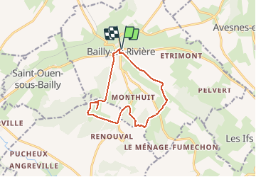
Tocht Stappen van 11 km beschikbaar op Normandië, Seine-Maritime, Bailly-en-Rivière. Deze tocht wordt voorgesteld door Papy Diouf.
Beschrijving
Circuit coupé par un cultivateur dans le bois de Farival par barbelés et clôture électrique sur le hameau de huppy alors que le chemin est balisé rando. Scandaleux
Plaatsbepaling
Land:
France
Regio :
Normandië
Departement/Provincie :
Seine-Maritime
Gemeente :
Bailly-en-Rivière
Locatie:
Unknown
Vertrek:(Dec)
Vertrek:(UTM)
380701 ; 5530300 (31U) N.
Opmerkingen
Wandeltochten in de omgeving
![Tocht Stappen Petit-Caux - DRC CHEMIN VERT DU PETIT-CAUX - Photo](https://media.geolcdn.com/t/375/260/ext.jpg?maxdim=2&url=https%3A%2F%2Fstatic1.geolcdn.com%2Fsiteimages%2Fupload%2Ffiles%2F1553511878bg_sport_marche.png)
![Stappen Stappen](https://static1.geolcdn.com/sitytour/trail-icons/101.png)
DRC CHEMIN VERT DU PETIT-CAUX
Stappen
Gemakkelijk
Petit-Caux,
Normandië,
Seine-Maritime,
France
![](/images/other/stat-length.png)
16,7 km | 18,9 km-effort
4h 17min
![](https://static1.geolcdn.com/siteimages/upload/files/16400158638029165_repeat_loop_refresh_sync_direction_icon.png)
Neen
![Tocht Te voet Petit-Caux - Chemin Vert du Petit Caux - Photo](https://media.geolcdn.com/t/375/260/ext.jpg?maxdim=2&url=https%3A%2F%2Fstatic1.geolcdn.com%2Fsiteimages%2Fupload%2Ffiles%2F1545311037marcheuse_200dpi.jpg)
![Te voet Te voet](https://static1.geolcdn.com/sitytour/trail-icons/100.png)
Chemin Vert du Petit Caux
Te voet
Gemakkelijk
Petit-Caux,
Normandië,
Seine-Maritime,
France
![](/images/other/stat-length.png)
16,6 km | 18,8 km-effort
4h 16min
![](https://static1.geolcdn.com/siteimages/upload/files/16400158638029165_repeat_loop_refresh_sync_direction_icon.png)
Neen
![Tocht Te voet Saint-Martin-le-Gaillard - Gratte-Panche - Photo](https://media.geolcdn.com/t/375/260/ext.jpg?maxdim=2&url=https%3A%2F%2Fstatic1.geolcdn.com%2Fsiteimages%2Fupload%2Ffiles%2F1545311037marcheuse_200dpi.jpg)
![Te voet Te voet](https://static1.geolcdn.com/sitytour/trail-icons/100.png)
Gratte-Panche
Te voet
Medium
Saint-Martin-le-Gaillard,
Normandië,
Seine-Maritime,
France
![](/images/other/stat-length.png)
16 km | 20 km-effort
4h 33min
![](https://static1.geolcdn.com/siteimages/upload/files/16400158638029165_repeat_loop_refresh_sync_direction_icon.png)
Ja
![Tocht Stappen Petit-Caux - greny petit caux - Photo](https://media.geolcdn.com/t/375/260/46a6631d-07a1-4e84-b52e-ffa471157c7c.jpg&format=jpg&maxdim=2)
![Stappen Stappen](https://static1.geolcdn.com/sitytour/trail-icons/101.png)
greny petit caux
Stappen
Moeilijk
Petit-Caux,
Normandië,
Seine-Maritime,
France
![](/images/other/stat-length.png)
10,7 km | 12,3 km-effort
1h 49min
![](https://static1.geolcdn.com/siteimages/upload/files/16400158638029165_repeat_loop_refresh_sync_direction_icon.png)
Ja
![Tocht Stappen Saint-Ouen-sous-Bailly - Saint Ouen sous Bailly - Photo](https://media.geolcdn.com/t/375/260/ext.jpg?maxdim=2&url=https%3A%2F%2Fstatic1.geolcdn.com%2Fsiteimages%2Fupload%2Ffiles%2F1553511878bg_sport_marche.png)
![Stappen Stappen](https://static1.geolcdn.com/sitytour/trail-icons/101.png)
Saint Ouen sous Bailly
Stappen
Gemakkelijk
Saint-Ouen-sous-Bailly,
Normandië,
Seine-Maritime,
France
![](/images/other/stat-length.png)
5,2 km | 6,1 km-effort
1h 19min
![](https://static1.geolcdn.com/siteimages/upload/files/16400158638029165_repeat_loop_refresh_sync_direction_icon.png)
Neen
![Tocht Stappen Envermeu - ENVERMEU (St Ouen S/BAILLY) - Photo](https://media.geolcdn.com/t/375/260/ext.jpg?maxdim=2&url=https%3A%2F%2Fstatic1.geolcdn.com%2Fsiteimages%2Fupload%2Ffiles%2F1553511878bg_sport_marche.png)
![Stappen Stappen](https://static1.geolcdn.com/sitytour/trail-icons/101.png)
ENVERMEU (St Ouen S/BAILLY)
Stappen
Medium
(1)
Envermeu,
Normandië,
Seine-Maritime,
France
![](/images/other/stat-length.png)
9,2 km | 11,2 km-effort
2h 33min
![](https://static1.geolcdn.com/siteimages/upload/files/16400158638029165_repeat_loop_refresh_sync_direction_icon.png)
Ja
![Tocht Stappen Envermeu - ENVERMEU (st Ouen ) - Photo](https://media.geolcdn.com/t/375/260/ext.jpg?maxdim=2&url=https%3A%2F%2Fstatic1.geolcdn.com%2Fsiteimages%2Fupload%2Ffiles%2F1553511878bg_sport_marche.png)
![Stappen Stappen](https://static1.geolcdn.com/sitytour/trail-icons/101.png)
ENVERMEU (st Ouen )
Stappen
Moeilijk
Envermeu,
Normandië,
Seine-Maritime,
France
![](/images/other/stat-length.png)
10,9 km | 12,7 km-effort
2h 53min
![](https://static1.geolcdn.com/siteimages/upload/files/16400158638029165_repeat_loop_refresh_sync_direction_icon.png)
Ja