![](/images/other/stat-length.png)
![Tocht Stappen Baztan - Wikiloc - BURGA desde Arizkun, regreso por Erratzu - Photo](https://media.geolcdn.com/t/1900/400/ext.pjpeg?maxdim=2&url=https%3A%2F%2Fstatic1.geolcdn.com%2Fsiteimages%2Fupload%2Ffiles%2F1553511878bg_sport_marche.png)
Wikiloc - BURGA desde Arizkun, regreso por Erratzu
DECHAMPD
Gebruiker
![Lengte](/images/other/stat-length.png)
![Max. hoogte](https://static1.geolcdn.com/siteimages/upload/files/1508320355ic_sort_altitude_max_24dp.png)
![Positief hoogteverschil](https://static1.geolcdn.com/siteimages/upload/files/1508320355ic_sort_den_pos_24dp.png)
![Km-Effort](/images/other/stat-length.png)
![Min. hoogte](https://static1.geolcdn.com/siteimages/upload/files/1508320355ic_sort_altitude_min_24dp.png)
![Negatief hoogteverschil](https://static1.geolcdn.com/siteimages/upload/files/1508320355ic_sort_den_neg_24dp.png)
![Boucle](https://static1.geolcdn.com/siteimages/upload/files/16400158638029165_repeat_loop_refresh_sync_direction_icon.png)
![Stappen](https://static1.geolcdn.com/sitytour/trail-icons/101.png)
4h48
Moeilijkheid : Zeer moeilijk
![Scan deze QR-code om de tocht te openen in de SityTrail-applicatie](https://capi.geolives.com/qq0zvz2zws4bq2lad0pu/sitytour/trails/2602246/qr.png?size=200)
Gratisgps-wandelapplicatie
Over ons
Tocht Stappen van 14,7 km beschikbaar op Navarra - Nafarroa, Onbekend, Baztan. Deze tocht wordt voorgesteld door DECHAMPD.
Beschrijving
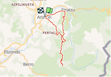
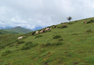
Cet itinéraire traverse la magnifique vallée de Baztan (Navarre). Une partie est circulaire de sorte que, vue sur la carte, elle ressemble à une sucette triangulaire.
Il commence à Arizkun, où vous prenez le PR Na4 (PR de Baztangoiza) en direction SE et sur 1,5 km jusqu'au waypoint «confluencia». À la fin du mois d'octobre 2020, j'ai trouvé environ 3 chênes américains tombés, bien qu'ils puissent être sauvés sans grandes difficultés. Le chêne américain est une espèce envahissante en Navarre qui «peut» avec le chêne indigène mais, heureusement, dans les gros coups de vent, il est plus facilement abattu en raison de son système racinaire médiocre. Les forts coups de vent sont un moyen naturel de les faire disparaître.
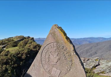
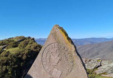
Depuis le point d'accès "confluencia", et par un chemin simple, nous allons dans une direction S jusqu'au premier sommet, appelé Soralar (Soalar), d'où nous aurons des vues panoramiques spectaculaires. Jusqu'à présent, nous aurons parcouru 5,2 km avec des pentes douces.
En un peu plus de 1 km, nous atteignons Burga, haut de la 1ère catégorie, d'où nous profiterons également de belles vues.
Pour revenir nous reviendrons vers le wp "confluencia", où nous tournons à droite jusqu'à rejoindre le PR Na7 (Iñarbegi-Xorroxin), qui nous mènera aux environs d'Erratzu. De là, et par le chemin-piste qui relie Erratzu à Arizcun, nous atteindrons notre point de départ.
Distance: 14,7 km
Dénivelé : 700 mètres
Temps de déplacement: 3 heures et 25 min
POI's
Plaatsbepaling
Opmerkingen
Wandeltochten in de omgeving
![Tocht Stappen Baztan - SityTrail - Le Legate depuis Lekaroz - Photo](https://media.geolcdn.com/t/375/260/3a7849ca-5caa-42b4-972a-045a6773fe6b.png&format=jpg&maxdim=2)
![Stappen Stappen](https://static1.geolcdn.com/sitytour/trail-icons/101.png)
Stappen
![](/images/other/stat-length.png)
![](https://static1.geolcdn.com/siteimages/upload/files/16400158638029165_repeat_loop_refresh_sync_direction_icon.png)
![Tocht Te voet Baztan - SL-NA 12 Xorroxin - Photo](https://media.geolcdn.com/t/375/260/c70a4708-6618-4ddb-8631-b64345aa0ab6.jpeg&format=jpg&maxdim=2)
![Te voet Te voet](https://static1.geolcdn.com/sitytour/trail-icons/100.png)
Te voet
![](/images/other/stat-length.png)
![](https://static1.geolcdn.com/siteimages/upload/files/16400158638029165_repeat_loop_refresh_sync_direction_icon.png)
![Tocht Stappen Baztan - Le Legare 2024/08/16 - Photo](https://media.geolcdn.com/t/375/260/b9d59c9e-9c2d-4d32-b82f-56e0018c96e6.jpg&format=jpg&maxdim=2)
![Stappen Stappen](https://static1.geolcdn.com/sitytour/trail-icons/101.png)
Stappen
![](/images/other/stat-length.png)
![](https://static1.geolcdn.com/siteimages/upload/files/16400158638029165_repeat_loop_refresh_sync_direction_icon.png)
![Tocht Stappen Baztan - 2024/05/28 Elizondo départ Parking - Photo](https://media.geolcdn.com/t/375/260/5c2f942c-76ba-4b7a-a400-474036e6852e.jpg&format=jpg&maxdim=2)
![Stappen Stappen](https://static1.geolcdn.com/sitytour/trail-icons/101.png)
Stappen
![](/images/other/stat-length.png)
![](https://static1.geolcdn.com/siteimages/upload/files/16400158638029165_repeat_loop_refresh_sync_direction_icon.png)
![Tocht Stappen Baztan - Le Legate depuis Lekaroz - Photo](https://media.geolcdn.com/t/375/260/88a262ce-e547-48ba-a39b-a474213cc0c5.jpg&format=jpg&maxdim=2)
![Stappen Stappen](https://static1.geolcdn.com/sitytour/trail-icons/101.png)
Stappen
![](/images/other/stat-length.png)
![](https://static1.geolcdn.com/siteimages/upload/files/16400158638029165_repeat_loop_refresh_sync_direction_icon.png)
![Tocht Paardrijden Baztan - Elizondo - Urdax - Photo](https://media.geolcdn.com/t/375/260/2940b90d-34c9-430c-88c8-3b80dad8731b.jpg&format=jpg&maxdim=2)
![Paardrijden Paardrijden](https://static1.geolcdn.com/sitytour/trail-icons/301.png)
Paardrijden
![](/images/other/stat-length.png)
![](https://static1.geolcdn.com/siteimages/upload/files/16400158638029165_repeat_loop_refresh_sync_direction_icon.png)
![Tocht Stappen Baztan - Umboto Larondo depuis Azpikueta - Photo](https://media.geolcdn.com/t/375/260/2e52e0d7-98cc-42d6-99d8-37338c4b3887.jpg&format=jpg&maxdim=2)
![Stappen Stappen](https://static1.geolcdn.com/sitytour/trail-icons/101.png)
Stappen
![](/images/other/stat-length.png)
![](https://static1.geolcdn.com/siteimages/upload/files/16400158638029165_repeat_loop_refresh_sync_direction_icon.png)
![Tocht Stappen Baztan - La Cascade Xorroxin et le Dolmen Inarbegi depuis Erratzu - Photo](https://media.geolcdn.com/t/375/260/ext.jpg?maxdim=2&url=https%3A%2F%2Fstatic1.geolcdn.com%2Fsiteimages%2Fupload%2Ffiles%2F1553511878bg_sport_marche.png)
![Stappen Stappen](https://static1.geolcdn.com/sitytour/trail-icons/101.png)
Stappen
![](/images/other/stat-length.png)
![](https://static1.geolcdn.com/siteimages/upload/files/16400158638029165_repeat_loop_refresh_sync_direction_icon.png)
![Tocht Stappen Baztan - etapa03_nuevo - Photo](https://media.geolcdn.com/t/375/260/ext.jpg?maxdim=2&url=https%3A%2F%2Fstatic1.geolcdn.com%2Fsiteimages%2Fupload%2Ffiles%2F1553511878bg_sport_marche.png)
![Stappen Stappen](https://static1.geolcdn.com/sitytour/trail-icons/101.png)
Stappen
![](/images/other/stat-length.png)
![](https://static1.geolcdn.com/siteimages/upload/files/16400158638029165_repeat_loop_refresh_sync_direction_icon.png)