![](/images/other/stat-length.png)
![Tocht Stappen Luik - Robermont-Jupille - Photo](https://media.geolcdn.com/t/1900/400/ae42662a-24d5-48c6-96f6-dd995394b09c.jpg&format=pjpeg&maxdim=2)
Robermont-Jupille
Mudry
Gebruiker
![Lengte](/images/other/stat-length.png)
Lengte
5,6 km
![Max. hoogte](https://static1.geolcdn.com/siteimages/upload/files/1508320355ic_sort_altitude_max_24dp.png)
Max. hoogte
171 m
![Positief hoogteverschil](https://static1.geolcdn.com/siteimages/upload/files/1508320355ic_sort_den_pos_24dp.png)
Positief hoogteverschil
77 m
![Km-Effort](/images/other/stat-length.png)
Km-Effort
6,6 km
![Min. hoogte](https://static1.geolcdn.com/siteimages/upload/files/1508320355ic_sort_altitude_min_24dp.png)
Min. hoogte
119 m
![Negatief hoogteverschil](https://static1.geolcdn.com/siteimages/upload/files/1508320355ic_sort_den_neg_24dp.png)
Negatief hoogteverschil
73 m
![Boucle](https://static1.geolcdn.com/siteimages/upload/files/16400158638029165_repeat_loop_refresh_sync_direction_icon.png)
Boucle
Ja
Datum van aanmaak :
2020-11-08 14:39:25.961
Laatste wijziging :
2020-11-08 17:18:53.21
![Stappen](https://static1.geolcdn.com/sitytour/trail-icons/101.png)
1h21
Moeilijkheid : Heel gemakkelijk
![Scan deze QR-code om de tocht te openen in de SityTrail-applicatie](https://capi.geolives.com/qq0zvz2zws4bq2lad0pu/sitytour/trails/2596712/qr.png?size=200)
Gratisgps-wandelapplicatie
Over ons
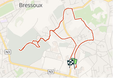
Tocht Stappen van 5,6 km beschikbaar op Wallonië, Luik, Luik. Deze tocht wordt voorgesteld door Mudry.
Beschrijving
Au départ de Grivegnée Haut (près du Delhaize), petit tour assez facile.
Une flânerie dans le cimetière de Robermont (parfois surnommé le Père Lachaise Liégeois), retour par les hauteurs de Jupille et retour au point de départ grâce à une petite incursion sur la Ligne 38 (RaVeL)
Plaatsbepaling
Land:
Belgium
Regio :
Wallonië
Departement/Provincie :
Luik
Gemeente :
Luik
Locatie:
Jupille-sur-Meuse
Vertrek:(Dec)
Vertrek:(UTM)
685419 ; 5611992 (31U) N.
Opmerkingen
Wandeltochten in de omgeving
![Tocht Stappen Chaudfontaine - RB-Lg-21_Chaudfontaine_via-racc-1-et-2 - Photo](https://media.geolcdn.com/t/375/260/ext.jpg?maxdim=2&url=https%3A%2F%2Fservices.sitytrail.com%2FGeolivesWS%2FDownloadMedia.ashx%3FTrailID%3D400756%26Media%3Db4e5d748-2e9a-46aa-887f-e41bafbe80d7.jpg)
![Stappen Stappen](https://static1.geolcdn.com/sitytour/trail-icons/101.png)
RB-Lg-21_Chaudfontaine_via-racc-1-et-2
Stappen
Moeilijk
(9)
Chaudfontaine,
Wallonië,
Luik,
Belgium
![](/images/other/stat-length.png)
11,6 km | 16,5 km-effort
3h 45min
![](https://static1.geolcdn.com/siteimages/upload/files/16400158638029165_repeat_loop_refresh_sync_direction_icon.png)
Ja
![Tocht Stappen Chaudfontaine - RB-Lg-21_Chaudfontaine - Photo](https://media.geolcdn.com/t/375/260/ext.jpg?maxdim=2&url=https%3A%2F%2Fservices.sitytrail.com%2FGeolivesWS%2FDownloadMedia.ashx%3FTrailID%3D400753%26Media%3D0173f844-fd8a-4443-984d-43fa65695365.jpg)
![Stappen Stappen](https://static1.geolcdn.com/sitytour/trail-icons/101.png)
RB-Lg-21_Chaudfontaine
Stappen
(14)
Chaudfontaine,
Wallonië,
Luik,
Belgium
![](/images/other/stat-length.png)
18 km | 26 km-effort
5h 56min
![](https://static1.geolcdn.com/siteimages/upload/files/16400158638029165_repeat_loop_refresh_sync_direction_icon.png)
Ja
![Tocht Stappen Luik - Nuit du scoutisme - Liège - Photo](https://media.geolcdn.com/t/375/260/9ee5fcc5-2ed6-4f9c-9105-1fa3b4422f73.jpg&format=jpg&maxdim=2)
![Stappen Stappen](https://static1.geolcdn.com/sitytour/trail-icons/101.png)
Nuit du scoutisme - Liège
Stappen
Gemakkelijk
(12)
Luik,
Wallonië,
Luik,
Belgium
![](/images/other/stat-length.png)
4,2 km | 6 km-effort
1h 19min
![](https://static1.geolcdn.com/siteimages/upload/files/16400158638029165_repeat_loop_refresh_sync_direction_icon.png)
Ja
![Tocht Stappen Luik - coteaux de la citadelle liège - Photo](https://media.geolcdn.com/t/375/260/ext.jpg?maxdim=2&url=https%3A%2F%2Fservices.sitytrail.com%2FGeolivesWS%2FDownloadMedia.ashx%3FTrailID%3D114030%26Media%3D89e4d7f6-fadf-43e4-96ab-3cccd7baadb9.jpg)
![Stappen Stappen](https://static1.geolcdn.com/sitytour/trail-icons/101.png)
coteaux de la citadelle liège
Stappen
Medium
(6)
Luik,
Wallonië,
Luik,
Belgium
![](/images/other/stat-length.png)
14,3 km | 19,8 km-effort
7h 4min
![](https://static1.geolcdn.com/siteimages/upload/files/16400158638029165_repeat_loop_refresh_sync_direction_icon.png)
Ja
![Tocht Stappen Blegny - 2023-07-28_14h00m33_1702.gpx.xml - Photo](https://media.geolcdn.com/t/375/260/08e717c2-a47c-47f0-9a4e-fb7b564b3f18.jpg&format=jpg&maxdim=2)
![Stappen Stappen](https://static1.geolcdn.com/sitytour/trail-icons/101.png)
2023-07-28_14h00m33_1702.gpx.xml
Stappen
Gemakkelijk
(1)
Blegny,
Wallonië,
Luik,
Belgium
![](/images/other/stat-length.png)
9,9 km | 11,8 km-effort
2h 40min
![](https://static1.geolcdn.com/siteimages/upload/files/16400158638029165_repeat_loop_refresh_sync_direction_icon.png)
Ja
![Tocht Stappen Luik - GG-Lg-10_Angleur - Nessonvaux - Photo](https://media.geolcdn.com/t/375/260/04d5e1fb-7fbe-4c80-8636-73a8d0ed7b0e.jpg&format=jpg&maxdim=2)
![Stappen Stappen](https://static1.geolcdn.com/sitytour/trail-icons/101.png)
GG-Lg-10_Angleur - Nessonvaux
Stappen
Zeer moeilijk
(2)
Luik,
Wallonië,
Luik,
Belgium
![](/images/other/stat-length.png)
22 km | 32 km-effort
6h 27min
![](https://static1.geolcdn.com/siteimages/upload/files/16400158638029165_repeat_loop_refresh_sync_direction_icon.png)
Neen
![Tocht Stappen Chaudfontaine - RB-Lg-21_Chaudfontaine_via-racc-1 - Photo](https://media.geolcdn.com/t/375/260/ext.jpg?maxdim=2&url=https%3A%2F%2Fservices.sitytrail.com%2FGeolivesWS%2FDownloadMedia.ashx%3FTrailID%3D400755%26Media%3Db4e5d748-2e9a-46aa-887f-e41bafbe80d7.jpg)
![Stappen Stappen](https://static1.geolcdn.com/sitytour/trail-icons/101.png)
RB-Lg-21_Chaudfontaine_via-racc-1
Stappen
Zeer moeilijk
(3)
Chaudfontaine,
Wallonië,
Luik,
Belgium
![](/images/other/stat-length.png)
14,9 km | 22 km-effort
5h 1min
![](https://static1.geolcdn.com/siteimages/upload/files/16400158638029165_repeat_loop_refresh_sync_direction_icon.png)
Ja
![Tocht Stappen Luik - liege st lambert versant gauche entre ville et nature - Photo](https://media.geolcdn.com/t/375/260/88c52680-ebe2-4244-8d59-4bcee560958c.jpg&format=jpg&maxdim=2)
![Stappen Stappen](https://static1.geolcdn.com/sitytour/trail-icons/101.png)
liege st lambert versant gauche entre ville et nature
Stappen
Medium
(1)
Luik,
Wallonië,
Luik,
Belgium
![](/images/other/stat-length.png)
10,5 km | 14 km-effort
2h 31min
![](https://static1.geolcdn.com/siteimages/upload/files/16400158638029165_repeat_loop_refresh_sync_direction_icon.png)
Ja
![Tocht Stappen Chaudfontaine - La découverte de Sauheid et rocher du bout du monde - Photo](https://media.geolcdn.com/t/375/260/13dd1432-7408-4af2-9183-0d845172c158.jpg&format=jpg&maxdim=2)
![Stappen Stappen](https://static1.geolcdn.com/sitytour/trail-icons/101.png)
La découverte de Sauheid et rocher du bout du monde
Stappen
Medium
(1)
Chaudfontaine,
Wallonië,
Luik,
Belgium
![](/images/other/stat-length.png)
7,8 km | 10,2 km-effort
2h 18min
![](https://static1.geolcdn.com/siteimages/upload/files/16400158638029165_repeat_loop_refresh_sync_direction_icon.png)
Ja