![](/images/other/stat-length.png)
![Tocht Stappen Saint-Denis - Saint-Denis Marche à pied - Photo](https://media.geolcdn.com/t/1900/400/40507a8a-072e-4af8-9e6d-ac8a2af9eddd.jpg&format=pjpeg&maxdim=2)
Saint-Denis Marche à pied
GilbertLP
Gebruiker
![Lengte](/images/other/stat-length.png)
![Max. hoogte](https://static1.geolcdn.com/siteimages/upload/files/1508320355ic_sort_altitude_max_24dp.png)
![Positief hoogteverschil](https://static1.geolcdn.com/siteimages/upload/files/1508320355ic_sort_den_pos_24dp.png)
![Km-Effort](/images/other/stat-length.png)
![Min. hoogte](https://static1.geolcdn.com/siteimages/upload/files/1508320355ic_sort_altitude_min_24dp.png)
![Negatief hoogteverschil](https://static1.geolcdn.com/siteimages/upload/files/1508320355ic_sort_den_neg_24dp.png)
![Boucle](https://static1.geolcdn.com/siteimages/upload/files/16400158638029165_repeat_loop_refresh_sync_direction_icon.png)
![Stappen](https://static1.geolcdn.com/sitytour/trail-icons/101.png)
4h09
Moeilijkheid : Moeilijk
![Scan deze QR-code om de tocht te openen in de SityTrail-applicatie](https://capi.geolives.com/qq0zvz2zws4bq2lad0pu/sitytour/trails/2594240/qr.png?size=200)
Gratisgps-wandelapplicatie
Over ons
Tocht Stappen van 12 km beschikbaar op Réunion, Onbekend, Saint-Denis. Deze tocht wordt voorgesteld door GilbertLP.
Beschrijving
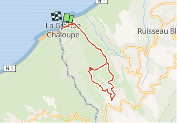
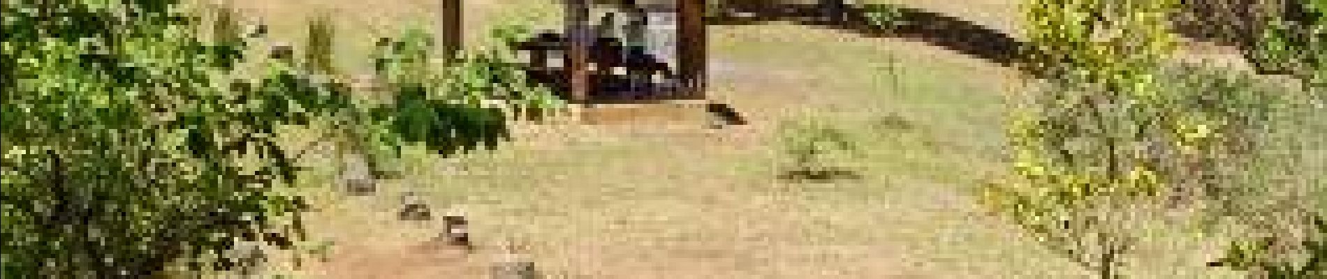
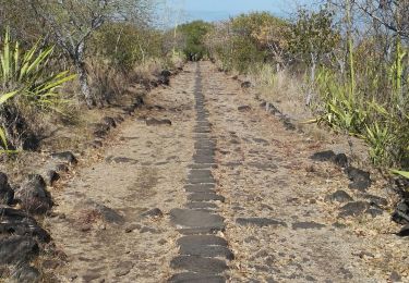
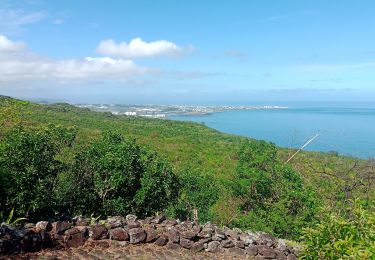
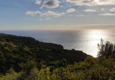
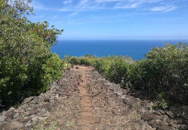
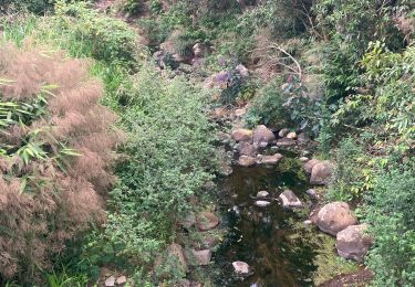
Randonnée au départ de la Grande Chaloupe, en empruntant le Chemin des anglais, en direction de Saint Bernard. Petite boucle autour du Domaine Fleurié, aire de pique-nique plantée d'arbres fruitiers, agréablement bien aménagé par le Conseil Départemental dans le secteur de la Grande Montagne. On peut y découvrir avec surprise une terre des 7 couleurs, au détour de la randonnée qui, bien que d'une longueur modeste (12 km), comporte tout de même un dénivelé positif de plus de 600 m. A découvrir en prenant son temps.
Plaatsbepaling
Opmerkingen
Wandeltochten in de omgeving
![Tocht Stappen La Possession - chemin des anglais - Photo](https://media.geolcdn.com/t/375/260/a9970942-5f60-4502-9255-bd733a142b53.jpg&format=jpg&maxdim=2)
![Stappen Stappen](https://static1.geolcdn.com/sitytour/trail-icons/101.png)
Stappen
![](/images/other/stat-length.png)
![](https://static1.geolcdn.com/siteimages/upload/files/16400158638029165_repeat_loop_refresh_sync_direction_icon.png)
![Tocht Stappen La Possession - Chemin des Anglais - Photo](https://media.geolcdn.com/t/375/260/faf29fcb-e9e1-4dc4-8cc4-62d8cdffd14b.jpg&format=jpg&maxdim=2)
![Stappen Stappen](https://static1.geolcdn.com/sitytour/trail-icons/101.png)
Stappen
![](/images/other/stat-length.png)
![](https://static1.geolcdn.com/siteimages/upload/files/16400158638029165_repeat_loop_refresh_sync_direction_icon.png)
![Tocht Stappen Saint-Denis - Boucle Moulin Kader - Photo](https://media.geolcdn.com/t/375/260/6bcbabda-093d-46f6-9fe0-c3dd014f0d9d.jpg&format=jpg&maxdim=2)
![Stappen Stappen](https://static1.geolcdn.com/sitytour/trail-icons/101.png)
Stappen
![](/images/other/stat-length.png)
![](https://static1.geolcdn.com/siteimages/upload/files/16400158638029165_repeat_loop_refresh_sync_direction_icon.png)
![Tocht Stappen Saint-Denis - Chemin des Anglais partiel - Photo](https://media.geolcdn.com/t/375/260/ext.jpg?maxdim=2&url=https%3A%2F%2Fservices.sitytrail.com%2FGeolivesWS%2FDownloadMedia.ashx%3FTrailID%3D873074%26Media%3Dfix__20171208104136.jpg)
![Stappen Stappen](https://static1.geolcdn.com/sitytour/trail-icons/101.png)
Stappen
![](/images/other/stat-length.png)
![](https://static1.geolcdn.com/siteimages/upload/files/16400158638029165_repeat_loop_refresh_sync_direction_icon.png)
![Tocht Trail La Possession - Possession-St Bernard(11K 780D+) - Photo](https://media.geolcdn.com/t/375/260/ab72601d-9382-4fb6-bf41-24ea78d3f5a7.jpg&format=jpg&maxdim=2)
![Trail Trail](https://static1.geolcdn.com/sitytour/trail-icons/104.png)
Trail
![](/images/other/stat-length.png)
![](https://static1.geolcdn.com/siteimages/upload/files/16400158638029165_repeat_loop_refresh_sync_direction_icon.png)
![Tocht Lopen La Possession - rosthone - Photo](https://media.geolcdn.com/t/375/260/ext.jpg?maxdim=2&url=https%3A%2F%2Fstatic1.geolcdn.com%2Fsiteimages%2Fupload%2Ffiles%2F1524743154running.jpg)
![Lopen Lopen](https://static1.geolcdn.com/sitytour/trail-icons/103.png)
Lopen
![](/images/other/stat-length.png)
![](https://static1.geolcdn.com/siteimages/upload/files/16400158638029165_repeat_loop_refresh_sync_direction_icon.png)
![Tocht Stappen Saint-Denis - Les kiosques depuis le Colorado - Photo](https://media.geolcdn.com/t/375/260/ext.jpg?maxdim=2&url=https%3A%2F%2Fstatic1.geolcdn.com%2Fsiteimages%2Fupload%2Ffiles%2F1553511878bg_sport_marche.png)
![Stappen Stappen](https://static1.geolcdn.com/sitytour/trail-icons/101.png)
Stappen
![](/images/other/stat-length.png)
![](https://static1.geolcdn.com/siteimages/upload/files/16400158638029165_repeat_loop_refresh_sync_direction_icon.png)
![Tocht Stappen Saint-Denis - Le chemin des anglais - Photo](https://media.geolcdn.com/t/375/260/ext.jpg?maxdim=2&url=https%3A%2F%2Fstatic1.geolcdn.com%2Fsiteimages%2Fupload%2Ffiles%2F1553511878bg_sport_marche.png)
![Stappen Stappen](https://static1.geolcdn.com/sitytour/trail-icons/101.png)
Stappen
![](/images/other/stat-length.png)
![](https://static1.geolcdn.com/siteimages/upload/files/16400158638029165_repeat_loop_refresh_sync_direction_icon.png)
![Tocht Stappen La Possession - sentier Kalla - Photo](https://media.geolcdn.com/t/375/260/ext.jpg?maxdim=2&url=https%3A%2F%2Fstatic1.geolcdn.com%2Fsiteimages%2Fupload%2Ffiles%2F1553511878bg_sport_marche.png)
![Stappen Stappen](https://static1.geolcdn.com/sitytour/trail-icons/101.png)
Stappen
![](/images/other/stat-length.png)
![](https://static1.geolcdn.com/siteimages/upload/files/16400158638029165_repeat_loop_refresh_sync_direction_icon.png)