![](/images/other/stat-length.png)
![Tocht Stappen Allos - Col de l'Encombrette par Allos Retour Pas de l'Echelle - Photo](https://media.geolcdn.com/t/1900/400/9c8277d6-b682-4086-8f1a-339298a932b2.jpg&format=pjpeg&maxdim=2)
Col de l'Encombrette par Allos Retour Pas de l'Echelle
GrouGary
Gebruiker
![Lengte](/images/other/stat-length.png)
![Max. hoogte](https://static1.geolcdn.com/siteimages/upload/files/1508320355ic_sort_altitude_max_24dp.png)
![Positief hoogteverschil](https://static1.geolcdn.com/siteimages/upload/files/1508320355ic_sort_den_pos_24dp.png)
![Km-Effort](/images/other/stat-length.png)
![Min. hoogte](https://static1.geolcdn.com/siteimages/upload/files/1508320355ic_sort_altitude_min_24dp.png)
![Negatief hoogteverschil](https://static1.geolcdn.com/siteimages/upload/files/1508320355ic_sort_den_neg_24dp.png)
![Boucle](https://static1.geolcdn.com/siteimages/upload/files/16400158638029165_repeat_loop_refresh_sync_direction_icon.png)
![Stappen](https://static1.geolcdn.com/sitytour/trail-icons/101.png)
7h22
Moeilijkheid : Medium
![Scan deze QR-code om de tocht te openen in de SityTrail-applicatie](https://capi.geolives.com/qq0zvz2zws4bq2lad0pu/sitytour/trails/2587799/qr.png?size=200)
Gratisgps-wandelapplicatie
Over ons
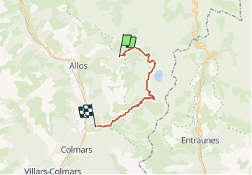
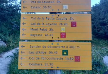
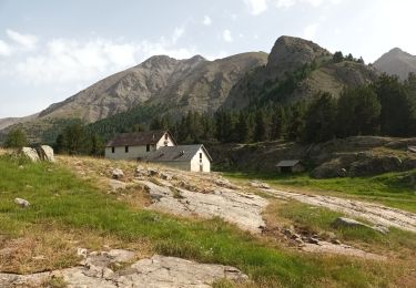
Tocht Stappen van 16,8 km beschikbaar op Provence-Alpes-Côte d'Azur, Alpes-de-Haute-Provence, Allos. Deze tocht wordt voorgesteld door GrouGary.
Beschrijving
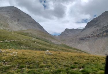
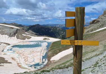
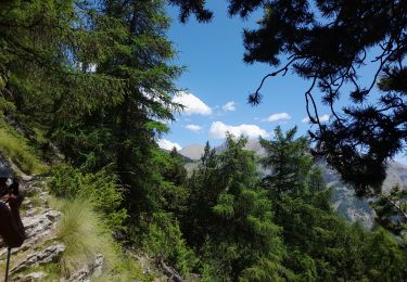
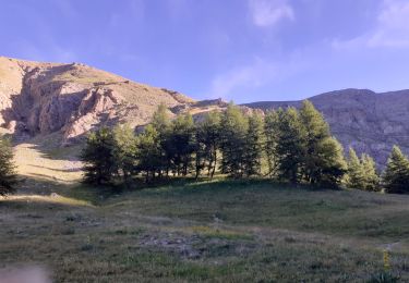
Magnifique boucle dans les mélèzes et érables flamboyants. Vues sur Grande Séolane, Mont Pelat, lac Allos et lacs de l'Encombrette.
Nombreux bouquetins peu farouches, chamois au col de l'Encombrette où l'approche se fait par une sente un peu enneigée.
Retour par l'adret plus chaud des lacs de l'Encombrette et les superbes zig zag du Pas de l'Echelle. Un dénivelé régulier mais long ;
2 voitures parking Allos et Clignon Haut
Plaatsbepaling
Opmerkingen
Wandeltochten in de omgeving
![Tocht Stappen Allos - ALLOS. LAC D ALLOS. COL DE LACAYOLE .O - Photo](https://media.geolcdn.com/t/375/260/dff6c4e7-81d7-4f55-8309-f016e1c29cdc.jpg&format=jpg&maxdim=2)
![Stappen Stappen](https://static1.geolcdn.com/sitytour/trail-icons/101.png)
Stappen
![](/images/other/stat-length.png)
![](https://static1.geolcdn.com/siteimages/upload/files/16400158638029165_repeat_loop_refresh_sync_direction_icon.png)
![Tocht Stappen Allos - le mont Pelat et le lac du trou de l'aigle - Photo](https://media.geolcdn.com/t/375/260/ext.jpg?maxdim=2&url=https%3A%2F%2Fservices.sitytrail.com%2FGeolivesWS%2FDownloadMedia.ashx%3FTrailID%3D791325%26Media%3D36a05fdf-444e-4dea-af98-fa2a609b54f1.JPG)
![Stappen Stappen](https://static1.geolcdn.com/sitytour/trail-icons/101.png)
Stappen
![](/images/other/stat-length.png)
![](https://static1.geolcdn.com/siteimages/upload/files/16400158638029165_repeat_loop_refresh_sync_direction_icon.png)
![Tocht Stappen Allos - ALLOS . LE PIOLAT . O - Photo](https://media.geolcdn.com/t/375/260/8431b62b-0416-4dfc-8061-d18b01fd6428.jpg&format=jpg&maxdim=2)
![Stappen Stappen](https://static1.geolcdn.com/sitytour/trail-icons/101.png)
Stappen
![](/images/other/stat-length.png)
![](https://static1.geolcdn.com/siteimages/upload/files/16400158638029165_repeat_loop_refresh_sync_direction_icon.png)
![Tocht Stappen Allos - ALLOS . LACS DE L ENCOMBRETTE . O - Photo](https://media.geolcdn.com/t/375/260/307a9bce-017e-4b9a-89e0-3a568ae2875c.jpg&format=jpg&maxdim=2)
![Stappen Stappen](https://static1.geolcdn.com/sitytour/trail-icons/101.png)
Stappen
![](/images/other/stat-length.png)
![](https://static1.geolcdn.com/siteimages/upload/files/16400158638029165_repeat_loop_refresh_sync_direction_icon.png)
![Tocht Stappen Allos - Pk du Laus - Lacs de la Petite Cayolle, des Garrets et Allos - Photo](https://media.geolcdn.com/t/375/260/6cd127f9-d150-47a2-89f3-9bfcf765a1b6.jpg&format=jpg&maxdim=2)
![Stappen Stappen](https://static1.geolcdn.com/sitytour/trail-icons/101.png)
Stappen
![](/images/other/stat-length.png)
![](https://static1.geolcdn.com/siteimages/upload/files/16400158638029165_repeat_loop_refresh_sync_direction_icon.png)
![Tocht Stappen Allos - Allos:rando à partir de la Haute Colette - Photo](https://media.geolcdn.com/t/375/260/493206fb-ef34-4df9-a198-c7ff23e42e5c.jpg&format=jpg&maxdim=2)
![Stappen Stappen](https://static1.geolcdn.com/sitytour/trail-icons/101.png)
Stappen
![](/images/other/stat-length.png)
![](https://static1.geolcdn.com/siteimages/upload/files/16400158638029165_repeat_loop_refresh_sync_direction_icon.png)
![Tocht Stappen Allos - Mont Pelat-Lac du Trou de l'Aigle-Tour du Lac d'Allos - Photo](https://media.geolcdn.com/t/375/260/a1822d13-72b2-42d9-8af2-259770b76d1c.jpg&format=jpg&maxdim=2)
![Stappen Stappen](https://static1.geolcdn.com/sitytour/trail-icons/101.png)
Stappen
![](/images/other/stat-length.png)
![](https://static1.geolcdn.com/siteimages/upload/files/16400158638029165_repeat_loop_refresh_sync_direction_icon.png)
![Tocht Stappen Allos - Col petite Cayolle-21-06-22 - Photo](https://media.geolcdn.com/t/375/260/f7f49d3e-1f88-497d-9a14-e5b0e459170b.jpg&format=jpg&maxdim=2)
![Stappen Stappen](https://static1.geolcdn.com/sitytour/trail-icons/101.png)
Stappen
![](/images/other/stat-length.png)
![](https://static1.geolcdn.com/siteimages/upload/files/16400158638029165_repeat_loop_refresh_sync_direction_icon.png)
![Tocht Stappen Allos - le pelage.lac d'allos - Photo](https://media.geolcdn.com/t/375/260/ae721351-d9a0-41da-8063-2d5b4b08a3fd.jpg&format=jpg&maxdim=2)
![Stappen Stappen](https://static1.geolcdn.com/sitytour/trail-icons/101.png)
Stappen
![](/images/other/stat-length.png)
![](https://static1.geolcdn.com/siteimages/upload/files/16400158638029165_repeat_loop_refresh_sync_direction_icon.png)